Ofahoma, Mississippi
Ofahoma is an unincorporated community in Leake County, Mississippi, United States. Ofahoma is located along Mississippi Highway 16 9.75 miles (15.69 km) west of Carthage.[2]
Ofahoma, Mississippi | |
|---|---|
 Ofahoma  Ofahoma | |
| Coordinates: 32°42′26″N 89°42′02″W | |
| Country | United States |
| State | Mississippi |
| County | Leake |
| Elevation | 341 ft (104 m) |
| Time zone | UTC-6 (Central (CST)) |
| • Summer (DST) | UTC-5 (CDT) |
| Area code(s) | 601 & 769 |
| GNIS feature ID | 692122[1] |
History
Ofahoma is a name derived from the Choctaw language meaning "Red Dog"; this name most likely was applied to a local Choctaw warrior.[3]
The community is located on the Yockanookany River and in 1900 had a population of 106.[4]
A post office operated under the name Ofahoma from 1866 to 1982.[5]
References
- "Ofahoma". Geographic Names Information System. United States Geological Survey, United States Department of the Interior.
- Leake County, Mississippi General Highway Map (PDF) (Map). Mississippi Department of Transportation. 2011. Retrieved April 8, 2012.
- Baca, Keith A. (2007). Native American Place Names in Mississippi. University Press of Mississippi. p. 70. ISBN 978-1-60473-483-6.
- Rowland, Dunbar (1907). Mississippi: Comprising Sketches of Counties, Towns, Events, Institutions, and Persons, Arranged in Cyclopedic Form (PDF). Vol. 2. Southern Historical Publishing Association. p. 356.
- "Leake County". Jim Forte Postal History. Retrieved January 16, 2023.
Municipalities and communities of Leake County, Mississippi, United States | ||
|---|---|---|
| City | 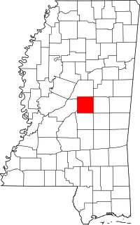 Map of Mississippi highlighting Leake County | |
| Towns | ||
| CDPs | ||
| Communities | ||
| Indian reservation | ||
| Footnotes | ‡This populated place also has portions in an adjacent county or counties | |
This article is issued from Wikipedia. The text is licensed under Creative Commons - Attribution - Sharealike. Additional terms may apply for the media files.