Ogre Municipality
Ogre Municipality (Latvian: Ogres novads) is a municipality in Vidzeme, Latvia. The municipality was formed in 2002 by merging Ogre town and Ogresgals Parish. In 2009 it absorbed Krape Parish, Ķeipene Parish, Laubere Parish, Madliena Parish, Mazozoli Parish, Meņģele Parish, Suntaži Parish and Taurupe Parish, the administrative centre being Ogre. The population in 2021 was 57,617.[3]
Ogre Municipality
Ogres novads | |
|---|---|
 Flag  Coat of arms | |
 | |
| Country | |
| Formed | 2002 |
| Reformed | 2021 |
| Centre | Ogre |
| Government | |
| • Council Chair | Egīls Helmanis (NA) |
| Area | |
| • Total | 1,839.42 km2 (710.20 sq mi) |
| • Land | 1,766.85 km2 (682.18 sq mi) |
| Population (2023)[2] | |
| • Total | 57,966 |
| • Density | 32/km2 (82/sq mi) |
| Website | www |
During the 2021 Latvian administrative reform, the previous municipality was merged with Ikšķile Municipality, Ķegums Municipality and Lielvārde Municipality. The new municipality now fully corresponds with the area of the former Ogre District.
Population
| Territorial unit | Population (year) |
|---|---|
| Birzgale Parish | 1518 (2021) |
| Ikšķile | 7278 (2021) |
| Jumprava Parish | 1662 (2021) |
| Krape parish | 605 (2021)[4] |
| Ķegums | 2103 (2021) |
| Ķeipene Parish | 849 (2021) |
| Laubere Parish | 568 (2021) |
| Lēdmane Parish | 1092 (2021) |
| Lielvārde | 5907 (2021) |
| Lielvārde Parish | 886 (2021) |
| Madliena Parish | 1476 (2021) |
| Mazozoli Parish | 437 (2021) |
| Meņģele Parish | 473 (2021) |
| Ogre | 22978 (2021) |
| Ogresgals Parish | 3055 (2021) |
| Rembate Parish | 1026 (2021) |
| Suntaži Parish | 1650 (2021) |
| Taurupe Parish | 699 (2021) |
| Tīnūži Parish | 2689 (2021) |
| Tome Parish | 666 (2021) |
Twin towns – sister cities
Images
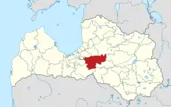
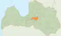 Boundaries of the municipality from 2009 to 2021
References
- "Reģionu, novadu, pilsētu un pagastu kopējā un sauszemes platība gada sākumā". Central Statistical Bureau of Latvia. Retrieved 18 January 2023.
- "Iedzīvotāju skaits pēc tautības reģionos, pilsētās, novados, pagastos, apkaimēs un blīvi apdzīvotās teritorijās gada sākumā (pēc administratīvi teritoriālās reformas 2021. gadā) 2021 - 2022". Central Statistical Bureau of Latvia. Retrieved 3 October 2023.
- "ISG020. Population number and its change by statistical region, city, town, 21 development centres and county". Central Statistical Bureau of Latvia. 2020-01-01. Retrieved 2021-02-12.
- "Archived copy" (PDF). Archived from the original (PDF) on 2018-10-09. Retrieved 2021-11-28.
{{cite web}}: CS1 maint: archived copy as title (link) - "Starptautiskā sadarbība" (in Latvian). Ogres novads. Retrieved 2023-08-02.
This article is issued from Wikipedia. The text is licensed under Creative Commons - Attribution - Sharealike. Additional terms may apply for the media files.