Valmiera Municipality
Valmiera Municipality (Latvian: Valmieras novads) is one of the 35 municipalities established in Latvia in 2021, located approximately 180 kilometres (110 mi) west of the national capital Riga. Its first elected municipal council took office on 1 July 2021. Its seat is the city of Valmiera.
Valmiera Municipality
Valmieras novads | |
|---|---|
![Valmiera town centre with St. Simon's Church [lv] in the background](../I/Valmiera_kesklinn.JPG.webp) Valmiera town centre with St. Simon's Church in the background | |
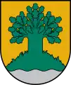
 Coat of arms | |
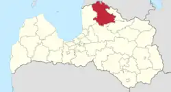
 Location of Valmiera Municipality in Latvia | |
| Coordinates: 57.55°N 25.45°E | |
| Country | |
| Established | 1 July 2021 |
| Seat | Valmiera |
| Area | |
| • Total | 2,948 km2 (1,138 sq mi) |
| Population | |
| • Estimate (1 January 2021)[1] | 51,370 |
| • Seat | 22,971 |
| Time zone | UTC+2 (EET) |
| • Summer (DST) | UTC+3 (EEST) |
| Website | http://www.valmiera.lv/ |
Geography


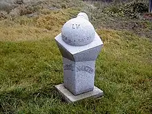
Valmiera Municipality covers an area of 2,948 square kilometres (1,138 sq mi).[1] It is located in the northwestern part of the Vidzeme region in northern Latvia, on the border with Estonia. It borders Valka Municipality to the east, Smiltene Municipality to the southeast, Cēsis Municipality to the south, and Limbaži Municipality to the west. It also borders the Estonian counties of Pärnu to the northwest, Viljandi to the north, and Valga to the northeast. The northernmost point of Latvia is located on the border with Estonia in Ipiķi Parish, and is marked with a sculpture by Vilnis Titāns.[2]
The highest point in Valmiera Municipality is Zilaiskalns with an elevation of 127 metres (417 ft) above sea level.[3] The hill was sacred to the ancient Latgalians and home to the Soviet-era folk healer Marta of Zilaiskalns.[4] The Sakala Upland extends from southern Estonia into the northern part of the municipality, its highest point in Latvia being Pikas kalns at 107.6 metres (353 ft) above sea level.[5]
The major rivers in the municipality are:
- the Gauja, whose course upstream of the city of Valmiera is protected by the Ziemeļgauja Protected Landscape Area,[6] and downstream of Valmiera by Gauja National Park;[7] and
- the Salaca, which drains Lake Burtnieks, the largest lake in the municipality.[3]
The northern part of the municipality lies within the North Vidzeme Biosphere Reserve.
History
In 2020, the Saeima approved reducing the number of municipal-level administrative divisions from 119 to 42. Valmiera Municipality was formed from the union of the city of Valmiera with Beverīna Municipality, Burtnieki Municipality, Kocēni Municipality, Mazsalaca Municipality, Naukšēni Municipality, Rūjiena Municipality, and Strenči Municipality.[8] Except for Strenči Municipality, these units were the constituents of the former Valmiera District. Elections for Latvia's new municipal councils were held on 5 June 2021,[9] and the new municipalities including Valmiera will go into effect on 1 July 2021.[8]
Administration
As of 2021, there are 19 seats on the Valmiera municipal council.[10]
The municipality is divided into the city of Valmiera, four towns and 26 parishes:[8][11]
- City
- Towns
- Parishes
- Bērzaine Parish
- Brenguļi Parish
- Burtnieki Parish
- Dikļi Parish
- Ēvele Parish
- Ipiķi Parish
- Jeri Parish
- Jērcēni Parish
- Kauguri Parish
- Kocēni Parish
- Ķoņi Parish
- Lode Parish
- Matīši Parish
- Mazsalaca Parish
- Naukšēni Parish
- Plāņi Parish
- Ramata Parish
- Rencēni Parish
- Sēļi Parish
- Skaņkalne Parish
- Trikāta Parish
- Vaidava Parish
- Vecate Parish
- Vecpils Parish
- Vilpulka Parish
- Zilaiskalns Parish
Demographics
Valmiera is Latvia's second most populous municipality behind Ogre Municipality.[12] The Central Statistical Bureau of Latvia estimated a population of 51,370 living in what is now Valmiera Municipality at the beginning of 2021. This represented a 24% decrease from an estimated population of 67,433 at the beginning of 2000, and a 11% decrease from an estimated population of 57,854 at the beginning of 2011.[1]
The city of Valmieras had an estimated population of 22,971 at the beginning of 2021.[13]
Economy and infrastructure
In 2018, the city of Valmiera recorded a gross domestic product per capita of €16,918, second highest among Latvian cities behind Riga.[14] It is a regional centre for manufacturing and education.[15][16] Vidzeme University of Applied Sciences is located in Valmiera.
Valmiera Municipality is crossed by national road A3 and the Riga–Lugaži Railway,[3] which serve to connect the municipality with Riga to the southwest and with Valka on the Estonian border to the northeast.
References
- Brinkhoff, Thomas (31 May 2021). "Latvia: Administrative Division". City Population. Retrieved 6 June 2021.
- "Ipiķu pagasts". Rūjiena Municipality. Retrieved 6 June 2021.
- "Rajons" (in Latvian). Valmiera District. Archived from the original on 2 June 2008.
- "Blue Hill (Zilaiskalns)". EnterGauja. Retrieved 6 June 2021.
- "The highest hill summits in Latvia". Official Statistics Portal. Central Statistical Bureau of Latvia. 16 April 2021. Retrieved 6 June 2021.
- "Ziemeļgauja" (in Latvian). Dabas aizsardzības pārvalde. 30 October 2020. Retrieved 6 June 2021.
- "Gauja National Park". Investment and Development Agency of Latvia. 30 October 2020. Retrieved 6 June 2021.
- "From mid-2021 onward Latvia will have 42 municipalities". Baltic News Network. 11 June 2020. Retrieved 6 June 2021.
- "Latvia votes in landmark local elections". LSM. 5 June 2021. Retrieved 6 June 2021.
- "Valmieras novada vadītāja Baika pārstāvētā partija saņem 12 no 19 deputātu mandātiem". TVNET (in Latvian). 6 June 2021. Retrieved 6 June 2021.
- "Law on Administrative Territories and Populated Areas". Likumi. Latvijas Vēstnesis. 22 June 2020. Retrieved 6 June 2021.
- Līcīte, Madara (10 June 2020). "Saeima nobalso par novadu reformu: būs 42 vietvaras, valstspilsētas un nulles līmeņa pašvaldības". LSM (in Latvian). Retrieved 6 June 2021.
- "IRD060. Population by sex in regions, cities, municipalities, towns and rural territories at the beginning of the year by Sex, Territorial unit, Indicator and Time period". National Statistical System of Latvia. Central Statistical Bureau of Latvia. 31 May 2021. Retrieved 6 June 2021.
- "Gross domestic product by region and city (at current prices) 2000 - 2018". Official Statistics Portal. Central Statistical Bureau of Latvia. 28 December 2020. Retrieved 6 June 2021.
- "1.5 % of total national value added is generated in Valmiera". Central Statistical Bureau of Latvia. 13 August 2020. Retrieved 6 June 2021.
- "About Valmiera". City of Valmiera. Retrieved 6 June 2021.