Tábor District
Tábor District (Czech: okres Tábor) is a district in the South Bohemian Region of the Czech Republic. Its capital is the town of Tábor.
Tábor District
Okres Tábor | |
|---|---|
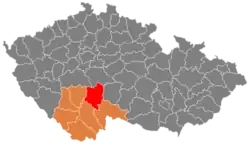 Location in the South Bohemian Region within the Czech Republic | |
| Coordinates: 49°23′N 14°41′E | |
| Country | |
| Region | South Bohemian |
| Capital | Tábor |
| Area | |
| • Total | 1,326.36 km2 (512.11 sq mi) |
| Population (2023)[2] | |
| • Total | 103,898 |
| • Density | 78/km2 (200/sq mi) |
| Time zone | UTC+1 (CET) |
| • Summer (DST) | UTC+2 (CEST) |
| Municipalities | 110 |
| * Towns | 9 |
| * Market towns | 3 |
Administrative division
Tábor District is divided into two administrative districts of municipalities with extended competence: Tábor and Soběslav.
List of municipalities
Towns are marked in bold and market towns in italics:
Balkova Lhota - Bechyně - Bečice - Běleč - Borkovice - Borotín - Bradáčov - Březnice - Budislav - Černýšovice - Chotěmice - Chotoviny - Choustník - Chrbonín - Chýnov - Dírná - Dlouhá Lhota - Dobronice u Bechyně - Dolní Hořice - Dolní Hrachovice - Dráchov - Drahov - Dražice - Dražičky - Drhovice - Haškovcova Lhota - Hlasivo - Hlavatce - Hodětín - Hodonice - Jedlany - Jistebnice - Katov - Klenovice - Komárov - Košice - Košín - Krátošice - Krtov - Libějice - Lom - Malšice - Mažice - Meziříčí - Mezná - Mladá Vožice - Mlýny - Myslkovice - Nadějkov - Nasavrky - Nemyšl - Nová Ves u Chýnova - Nová Ves u Mladé Vožice - Oldřichov - Opařany - Planá nad Lužnicí - Pohnánec - Pohnání - Pojbuky - Přehořov - Psárov - Radenín - Radětice - Radimovice u Tábora - Radimovice u Želče - Radkov - Rataje - Ratibořské Hory - Řemíčov - Řepeč - Řípec - Rodná - Roudná - Šebířov - Sedlečko u Soběslavě - Sezimovo Ústí - Skalice - Skopytce - Skrýchov u Malšic - Slapsko - Slapy - Smilovy Hory - Soběslav - Stádlec - Sudoměřice u Bechyně - Sudoměřice u Tábora - Sviny - Svrabov - Tábor - Třebějice - Tučapy - Turovec - Ústrašice - Val - Vesce - Veselí nad Lužnicí - Vilice - Vlastiboř - Vlčeves - Vlkov - Vodice - Zadní Střítež - Záhoří - Zálší - Želeč - Zhoř u Mladé Vožice - Zhoř u Tábora - Žíšov Zlukov - Zvěrotice
Geography
Most of the territory is characterized by an undulating landscape that turns into the tectonic depression in the south. The territory extends into four geomorphological mesoregions: Tábor Uplands (west and centre), Vlašim Uplands (north), Křemešník Highlands (east) and Třeboň Basin (south). The highest point of the district is the hill Batkovy in Pohnání with an elevation of 724 m (2,375 ft), the lowest point is the river bed of the Lužnice in Bechyně at 354 m (1,161 ft).
From the total district area of 1,326.4 km2 (512.1 sq mi), agricultural land occupies 776.7 km2 (299.9 sq mi), forests occupy 390.9 km2 (150.9 sq mi), and water area occupies 45.5 km2 (17.6 sq mi). Forests cover 29.5% of the district's area.[1]
The territory is rich in watercourses and ponds. The most important river is the Lužnice, which flows into the territory in the south, flows through it and turns to the southwest. In the south, the Nežárka flows into it. The area of the Třeboň Basin is known for its fishpond system, including the Horusický Pond, which is the second largest pond in the country with an area of 415 ha (1,030 acres). There are also many ponds in the rest of the district territory.
A small part of the protected landscape area of Třeboňsko extends into the district in the south.
Demographics
|
|
| ||||||||||||||||||||||||||||||||||||||||||||||||||||||
| Source: Censuses[3][4] | ||||||||||||||||||||||||||||||||||||||||||||||||||||||||
Most populated municipalities
| Name | Population[2] | Area (km2) |
|---|---|---|
| Tábor | 34,301 | 62 |
| Sezimovo Ústí | 7,166 | 8 |
| Soběslav | 6,966 | 20 |
| Veselí nad Lužnicí | 6,488 | 30 |
| Bechyně | 4,882 | 21 |
| Planá nad Lužnicí | 4,561 | 21 |
| Mladá Vožice | 2,697 | 32 |
| Chýnov | 2,536 | 31 |
| Jistebnice | 2,128 | 58 |
| Chotoviny | 1,918 | 31 |
Economy
The largest employers with headquarters in Tábor District and at least 500 employees are:[5]
| Economic entity | Location | Number of employees | Main activity |
|---|---|---|---|
| Tábor Hospital | Tábor | 1,000–1,499 | Health care |
| BRISK Tábor | Tábor | 500–999 | Automotive industry |
| Flosman | Tábor | 500–999 | Retail trade |
Transport
The D3 motorway, part of European route E55 leading from Prague to České Budějovice, runs across the district.
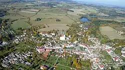
Sights
The most important monuments in the district, protected as national cultural monuments, are:[6]
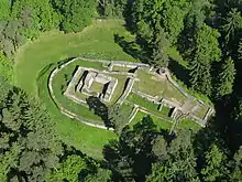
- Kozí hrádek Castle in Sezimovo Ústí
- Old Town Hall in Tábor
- Kotnov Castle with Bechyňská Gate in Tábor
- Stádlec Suspension Bridge
- Bechyně Bridge
- Altar Wings of Roudníky
- Monastery with the Church of the Assumption of the Virgin Mary in Tábor-Klokoty
The best-preserved settlements, protected as monument reservations and monument zones, are:[7]
The most visited tourist destinations are the Tábor Zoo and Hussite Museum in Tábor.[8]
Notable people
References
- "Land use (as at 31 December)". Public database. Czech Statistical Office. Retrieved 2023-05-18.
- "Population of Municipalities – 1 January 2023". Czech Statistical Office. 2023-05-23.
- "Historický lexikon obcí České republiky 1869–2011 – Okres Tábor" (in Czech). Czech Statistical Office. 2015-12-21. pp. 1–2.
- "Population Census 2021: Population by sex". Public Database. Czech Statistical Office. 2021-03-27.
- "Registr ekonomických subjektů". Business Register (in Czech). Czech Statistical Office. Retrieved 2023-01-30.
- "Výsledky vyhledávání: Národní kulturní památky, okres Tábor". Ústřední seznam kulturních památek (in Czech). National Heritage Institute. Retrieved 2023-05-24.
- "Výsledky vyhledávání: Památkové rezervace, Památkové zóny, okres Tábor". Ústřední seznam kulturních památek (in Czech). National Heritage Institute. Retrieved 2023-05-24.
- "Turisté mají v České republice nejraději zoologické zahrady, technické památky, koupání a Pražský hrad" (in Czech). CzechTourism. 2022-06-24. Retrieved 2023-05-24.
External links
- Tábor District – profile on the Czech Statistical Office website