Radenín
Radenín is a municipality and village in Tábor District in the South Bohemian Region of the Czech Republic. It has about 500 inhabitants.
Radenín | |
|---|---|
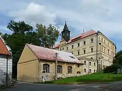 Radenín Castle | |
 Flag  Coat of arms | |
 Radenín Location in the Czech Republic | |
| Coordinates: 49°22′10″N 14°50′27″E | |
| Country | |
| Region | South Bohemian |
| District | Tábor |
| First mentioned | 1300 |
| Area | |
| • Total | 26.93 km2 (10.40 sq mi) |
| Elevation | 503 m (1,650 ft) |
| Population (2023-01-01)[1] | |
| • Total | 519 |
| • Density | 19/km2 (50/sq mi) |
| Time zone | UTC+1 (CET) |
| • Summer (DST) | UTC+2 (CEST) |
| Postal codes | 391 20, 391 55 |
| Website | www |
Administrative parts
Villages of Bítov, Hroby, Kozmice, Lažany, Nuzbely and Terezín are administrative parts of Radenín.
Geography
Radenín is located about 12 kilometres (7 mi) east of Tábor, 50 km (31 mi) northeast of České Budějovice. It lies in the Křemešník Highlands. The highest point is the Blaník hill at 659 m (2,162 ft) above sea level. The Turovecký Stream flows through the municipality.
Notable people
- Zuzana Černínová of Harasov, (1600/1601–1654), letter writer; died here
- Humprecht Jan Czernin (1628–1682), noble and diplomat
This article is issued from Wikipedia. The text is licensed under Creative Commons - Attribution - Sharealike. Additional terms may apply for the media files.