Teplice District
Teplice District (Czech: okres Teplice) is a district in the Ústí nad Labem Region of the Czech Republic. Its capital is the city of Teplice.
Teplice District
Okres Teplice | |
|---|---|
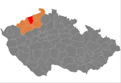 Location in the Ústí nad Labem Region within the Czech Republic | |
 | |
| Coordinates: 50°37′N 13°49′E | |
| Country | |
| Region | Ústí nad Labem |
| Capital | Teplice |
| Area | |
| • Total | 468.92 km2 (181.05 sq mi) |
| Population (2023)[2] | |
| • Total | 127,681 |
| • Density | 270/km2 (710/sq mi) |
| Time zone | UTC+1 (CET) |
| • Summer (DST) | UTC+2 (CEST) |
| Municipalities | 34 |
| * Cities and towns | 9 |
| * Market towns | 1 |
Administrative division
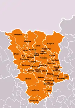
Teplice District is divided into two administrative districts of municipalities with extended competence: Teplice and Bílina.
List of municipalities
Cities and towns are marked in bold and market towns in italics:
Bílina - Bořislav - Bystřany - Bžany - Dubí - Duchcov - Háj u Duchcova - Hostomice - Hrob - Hrobčice - Jeníkov - Kladruby - Košťany - Kostomlaty pod Milešovkou - Krupka - Lahošť - Ledvice - Lukov - Měrunice - Mikulov - Modlany - Moldava - Novosedlice - Ohníč - Osek - Proboštov - Rtyně nad Bílinou - Srbice - Světec - Teplice - Újezdeček - Zabrušany - Žalany - Žim
Geography
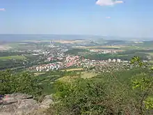
Teplice District borders Germany in the north. The terrain is very varied – hilly in the south, rather flat in the centre, and mountainous in the north. The territory extends into three geomorphological mesoregions: Central Bohemian Uplands (most of the territory), Most Basin (a strip across the territory from west to east) and Ore Mountains (north). The highest point of the district is the mountain Pramenáč in Košťany with an elevation of 910 m (2,990 ft), the lowest point is the river bed of the Bílina in Rtyně nad Bílinou at 160 m (520 ft).
From the total district area of 468.9 km2 (181.0 sq mi), agricultural land occupies 162.0 km2 (62.5 sq mi), forests occupy 184.4 km2 (71.2 sq mi), and water area occupies 8.5 km2 (3.3 sq mi). Forests cover 39.3% of the district's area.[1]
The most important river is the Bílina, which flows across the territory from west to east. There are several reservoirs and artificial lakes created by flooding mines. The largest of them is Barbora with an area of 65 ha (160 acres).[3]
České Středohoří is a protected landscape area that extends into the district.
Demographics
|
|
| ||||||||||||||||||||||||||||||||||||||||||||||||||||||
| Source: Censuses[4][5] | ||||||||||||||||||||||||||||||||||||||||||||||||||||||||
Economy
The largest employers with headquarters in Teplice District and at least 500 employees are:[6]
| Economic entity | Location | Number of employees | Main activity |
|---|---|---|---|
| AGC Automotive Czech | Bílina | 1,500–1,999 | Shaping and processing of flat glass |
| AGC Flat Glass Czech | Teplice | 1,000–1,499 | Manufacture of flat glass |
| Severočeská servisní | Teplice | 1,000–1,499 | Construction and maintenance of pipelines |
| PRODECO | Bílina | 500–999 | Manufacture of machinery for mining and quarrying |
| Revitrans | Bílina | 500–999 | Rental and maintenance of construction and mining machinery |
| Správa a údržba silnic Ústeckého kraje | Dubí | 500–999 | Road management and maintenance |
| Auto-Kabel Krupka | Krupka | 500–999 | Manufacture of electricity distribution for automotive industry |
| Personna International CZ | Krupka | 500–999 | Manufacture of razors |
| Tivall CZ | Krupka | 500–999 | Food industry |
| Severočeské vodovody a kanalizace | Teplice | 500–999 | Water collection, treatment and supply |
Transport
There are no motorways in the district territory. The most important road that passess through the district is the I/13 from Karlovy Vary to Liberec.
Sights
The mining cultural landscape of Krupka was designated a UNESCO World Heritage Site in 2019 as part of the transnational Ore Mountain Mining Region.[7]
The most important monuments in the district, protected as national cultural monuments, are:[8]
- Memorial to the victims of the Nelson Mine disaster in Osek
- Cistercian monastery in Osek
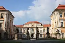
- Duchcov Castle
- Basilica of Our Lady of Sorrows in Krupka-Bohosudov
The best-preserved settlements, localities and landscapes, protected as monument reservations and monument zones, are:[9]
- Bílina-Pražské Předměstí (archeological monument reservation)
- Bílina
- Duchcov
- Krupka
- Teplice
- Mining cultural landscape of Krupka
The most visited tourist destination is the Regional Museum in Teplice.[10]
Notable people
References
- "Land use (as at 31 December)". Public database. Czech Statistical Office. Retrieved 2023-05-17.
- "Population of Municipalities – 1 January 2023". Czech Statistical Office. 2023-05-23.
- "Jezero Barbora v Oldřichově u Teplic" (in Czech). CzechTourism. Retrieved 2023-01-23.
- "Historický lexikon obcí České republiky 1869–2011 – Okres Teplice" (in Czech). Czech Statistical Office. 2015-12-21. pp. 1–2.
- "Population Census 2021: Population by sex". Public Database. Czech Statistical Office. 2021-03-27.
- "Registr ekonomických subjektů". Business Register (in Czech). Czech Statistical Office. Retrieved 2023-01-23.
- "Erzgebirge/Krušnohoří Mining Region". UNESCO. Retrieved 2023-01-23.
- "Výsledky vyhledávání: Národní kulturní památky, okres Teplice". Ústřední seznam kulturních památek (in Czech). National Heritage Institute. Retrieved 2023-01-23.
- "Výsledky vyhledávání: Památkové rezervace, Památkové zóny, okres Teplice". Ústřední seznam kulturních památek (in Czech). National Heritage Institute. Retrieved 2023-01-23.
- "Návštěvnost muzeí, galerií a památníků 2021" (in Czech). Národní informační a poradenské středisko pro kulturu. Retrieved 2023-03-20.
External links
- Teplice District – profile on the Czech Statistical Office website