Omala, Nigeria
Omala is a Local Government Area in Kogi State, Nigeria bounded in the north by the Benue River. Its headquarters are in the town of Abejukolo (or Abajikolo) in the north of the area at7°43′N 7°33′E.
Omala | |
|---|---|
 Omala Location in Nigeria | |
| Coordinates: 7°49′N 7°31′E | |
| Country | |
| State | Kogi State |
| Government | |
| • Chairman | Alhaji Yukubu Ibrahim Aboh |
| Area | |
| • Total | 1,667 km2 (644 sq mi) |
| Population (2006 census) | |
| • Total | 108,402 |
| Time zone | UTC+1 (WAT) |
| 3-digit postal code prefix | 270 |
| ISO 3166 code | NG.KO.OM |
The northeasterly line of equal latitude and longitude passes through the southeast of the LGA.
It has an area of 1,667 km2 (644 sq mi) and a population of 108,402 at the 2006 census.[1] As of 2016, the population grew to 145,700.[2]
Most locals are predominantly Igala speaking people with a few being Bassa and Agatu from Benue State.
The postal code of the area is 270.[3]
Climate
In town of Abejukolo which is the headquarters of Omala LGA of Kogi state, the rainy season is oppressive and overcast while the dry season is humid and partly cloudy, and it is hot year round. Over the course of the year, the temperature typically varies from 64 °F to 94 °F and is rarely below 58 °F or above 99 °F.[4]
References
- HASC, population, area and Headquarters Statoids
- "Kogi (State, Nigeria) - Population Statistics, Charts, Map and Location". www.citypopulation.de. Retrieved 2018-09-18.
- "Post Offices- with map of LGA". NIPOST. Archived from the original on 2012-11-26. Retrieved 2009-10-20.
- "Abejukolo Climate, Weather By Month, Average Temperature (Nigeria) - Weather Spark". weatherspark.com. Retrieved 2022-12-21.
State capital: Lokoja | ||
| Local Government Areas | 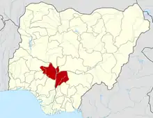 | |