Orewa
Orewa is a suburb of Auckland, New Zealand’s largest city. It lies on the Hibiscus Coast, just north of the base of the Whangaparaoa Peninsula and 40 kilometres north of central Auckland. It is a popular holiday destination.
Orewa | |
|---|---|
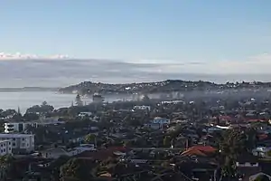 Orewa township, looking south towards the Whangaparaoa Peninsula | |
| Coordinates: 36.585°S 174.695°E | |
| Country | New Zealand |
| City | Auckland |
| Local authority | Auckland Council |
| Electoral ward | Albany ward |
| Local board | Hibiscus and Bays |
| Area | |
| • Land | 680 ha (1,680 acres) |
| Population (June 2023)[2] | |
| • Total | 10,820 |
| Postcode(s) | 0931, 0932 |
| Hatfields Beach | ||
| Wainui |
|
(Whangaparaoa Bay) |
| Silverdale | Red Beach | Stanmore Bay |
The Northern Motorway, part of State Highway 1, passes just inland of Orewa and extends through the twin Johnston Hill tunnels to near Puhoi. Orewa was administered as part of the Rodney District for two decades, until this was subsumed into the new Auckland Council in October 2010.
History
In the late 19th and early 20th centuries, Orewa and the Weiti River (then known as the Wade River) were a major locations for the kauri gum digging trade.[3]
Demographics
Orewa covers 6.80 km2 (2.63 sq mi)[1] and had an estimated population of 10,820 as of June 2023,[2] with a population density of 1,591 people per km2.
| Year | Pop. | ±% p.a. |
|---|---|---|
| 2006 | 7,371 | — |
| 2013 | 8,589 | +2.21% |
| 2018 | 10,242 | +3.58% |
| Source: [4] | ||
Orewa had a population of 10,242 at the 2018 New Zealand census, an increase of 1,653 people (19.2%) since the 2013 census, and an increase of 2,871 people (38.9%) since the 2006 census. There were 4,389 households, comprising 4,599 males and 5,643 females, giving a sex ratio of 0.81 males per female, with 1,287 people (12.6%) aged under 15 years, 1,170 (11.4%) aged 15 to 29, 3,720 (36.3%) aged 30 to 64, and 4,062 (39.7%) aged 65 or older.
Ethnicities were 86.1% European/Pākehā, 6.1% Māori, 2.7% Pacific peoples, 11.0% Asian, and 1.9% other ethnicities. People may identify with more than one ethnicity.
The percentage of people born overseas was 35.8, compared with 27.1% nationally.
Although some people chose not to answer the census's question about religious affiliation, 42.2% had no religion, 47.6% were Christian, 0.1% had Māori religious beliefs, 1.5% were Hindu, 0.5% were Muslim, 0.8% were Buddhist and 1.3% had other religions.
Of those at least 15 years old, 1,707 (19.1%) people had a bachelor's or higher degree, and 1,683 (18.8%) people had no formal qualifications. 1,530 people (17.1%) earned over $70,000 compared to 17.2% nationally. The employment status of those at least 15 was that 3,210 (35.8%) people were employed full-time, 1,107 (12.4%) were part-time, and 165 (1.8%) were unemployed.[4]
| Name | Area (km2) | Population | Density (per km2) | Households | Median age | Median income |
|---|---|---|---|---|---|---|
| Orewa North | 3.04 | 4,098 | 1,348 | 1,569 | 52.4 years | $30,600[5] |
| Orewa South | 2.31 | 3,048 | 1,319 | 1,371 | 60.5 years | $25,400[6] |
| Orewa Central | 1.45 | 3,096 | 2,135 | 1,449 | 58.1 years | $27,700[7] |
| New Zealand | 37.4 years | $31,800 |
Education
Orewa District High School was founded in 1956. In 1974, the school was split into Orewa School and Orewa College. Orewa North School was founded in 1978, and another primary school opened at Red Beach to the south in 1988.[8]
Orewa College is a secondary (years 7-13) school with a roll of 2014 students.[9]
Orewa School and Orewa North School are contributing primary (years 1-6) schools, with rolls of 454 students[10] and 396 students[11] respectively.
All three schools are coeducational. Rolls are as of April 2023.[12]
Gallery
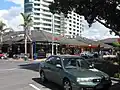 Shops in Orewa town centre
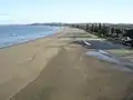 Ōrewa Beach
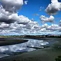 Ōrewa River
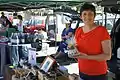 Orewa Market
Orewa Speech
Orewa made political headlines on 27 January 2004, when New Zealand National Party leader Don Brash, then the leader of the opposition in Parliament, gave what became known as the Orewa speech in front of the local Rotary club on a theme of race relations in New Zealand and, in particular, the special status of Māori. He advocated 'one rule for all'.[13]
References
- "ArcGIS Web Application". statsnz.maps.arcgis.com. Retrieved 29 May 2022.
- "Population estimate tables - NZ.Stat". Statistics New Zealand. Retrieved 25 October 2023.
- Hayward, Bruce W. (1989). Kauri Gum and the Gumdiggers. The Bush Press. p. 4. ISBN 0-908608-39-X.
- "Statistical area 1 dataset for 2018 Census". Statistics New Zealand. March 2020. Orewa North (112700), Orewa South (112900) and Orewa Central (113000).
- 2018 Census place summary: Orewa North
- 2018 Census place summary: Orewa South
- 2018 Census place summary: Orewa Central
- "Our School". Orewa Primary School. Retrieved 24 August 2008.
- Education Counts: Orewa College
- Education Counts: Orewa School
- Education Counts: Orewa North School
- "New Zealand Schools Directory". New Zealand Ministry of Education. Retrieved 12 December 2022.
- "Nationhood - Don Brash Speech Orewa Rotary Club". Scoop Independent News. Scoop Media. Retrieved 22 November 2020.