Oron, Nigeria
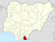
Oron is a coastal city and Local Government Area in Akwa Ibom State, Nigeria. It is home to the Maritime Academy of Nigeria and the Oron Museum.[1]
Oron
Ákánā Ōbió Ōró Oron Central | |
|---|---|
LGA and Town | |
 Oron Location in Nigeria | |
| Coordinates: 4°50′0″N 8°14′0″E | |
| Country | Nigeria |
| State | Akwa Ibom State |
| Capital | Uya Oro |
| Created | 1970 |
| Government | |
| • Chairman | Efiong Bassey Ubokulo |
| Area | |
| • Total | 70 km2 (30 sq mi) |
| Population (2006 Census) | |
| • Total | 105,461 |
| Time zone | UTC+1 (WAT) |
| Postal code | 523 |
| Area code(s) | 523121, 523120, 523118, 523101. |
| Climate | Am |
It has an area of 70 km2 and a population of 156,461 at the 2006 census.
The postal code of the area is 523.[2]
History
Oron became a Division in August 1970 and in 1976, was made a Local Government Area. However, following the local government creation exercise of the federal government in 1989, Oron was split into 3 Local Government Areas of Mbo, Akwa Ibom Oron, Akwa Ibom and Okobo, Akwa Ibom. Again in September 1991, Urue-Offong/Oruko Local Government Area was carved out of Oron Local Government Area. Finally in December 1996, Udung Uko Local Government Area was further carved out of Oron.
Clan and settlement
Oron Town as it is popularly known is made up of four (4) out of the Nine (9) Oron people clans (Afaha) which are.[3]
Afaha Okpo Clan also known as Afaha Okpo District includes
- Esin Ufot
- Esuk Oro
- Eyo Ekung Inyang
- Eyo Obiosio
- Udung Esin
- Udung Ulo
- Udung Usotia
- Udung Ekung
- Ikwita
Ibighi Clan also known as Uya Oro District includes
Afaha Ukwong Clan which is today known as Eyo Abasi District includes
Afaha Ubodung Clan now known as Eyotong District comprises
Geography
Oron is in the tropical region and has a uniformly high temperature all the year round. The two main seasons are the dry which spans between October and April and wet season which starts around May and ends in September. There are also two prevailing winds – the South-West onshore winds which brings heavy rains and the North- East trade winds blowing across the Sahara Desert, which brings in the dry season.
Natural resources
The region is extremely fertile and is known for its topographical Oil Palm Belt, tropical rainforest, swamps, and beaches. The mangrove forests also provide timber and raw materials for medicinal purposes. There are also deposits of solid minerals such as iron, free silica or glass sand and gravel. Seafoods such as crayfish, snipers, oyster and periwinkle abound richly. Oron is also rich in oil and natural gas. Most of its oil reserves are off-shore with large amounts of untapped natural gas.
See also
References
- "Maritime Academy of Nigeria". Maritime Academy of Nigeria. Archived from the original on 2007-06-15. Retrieved 2010-03-22.
- "Post Offices- with map of LGA". NIPOST. Archived from the original on 2009-10-07. Retrieved 2009-10-20.
- "List of Towns and Villages in Oron LGA". 24 February 2014.
