Otter Plain
Otter Plain (71°30′S 7°30′E) is an ice plain between Sigurd Knolls on the north and the Muhlig-Hofmann and Drygalski Mountains on the south, in Queen Maud Land. Plotted from surveys and air photos by the Norwegian Antarctic Expedition (1956–60) and named after the Otter aircraft used by the expedition.
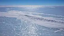
Otter Plain (looking NE) with Sigurd Knolls in the center near the horizon, roughly 27 miles (44 km) in the distance. Queen Maud Land, Antarctica.
![]() This article incorporates public domain material from "Otter Plain". Geographic Names Information System. United States Geological Survey.
This article incorporates public domain material from "Otter Plain". Geographic Names Information System. United States Geological Survey.
This article is issued from Wikipedia. The text is licensed under Creative Commons - Attribution - Sharealike. Additional terms may apply for the media files.