Předklášteří
Předklášteří is a municipality and village in Brno-Country District in the South Moravian Region of the Czech Republic. It has about 1,400 inhabitants.
Předklášteří | |
|---|---|
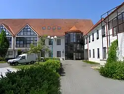
 Municipal office | |
 Flag  Coat of arms | |
 Předklášteří Location in the Czech Republic | |
| Coordinates: 49°21′9″N 16°24′9″E | |
| Country | |
| Region | South Moravian |
| District | Brno-Country |
| First mentioned | 1530 |
| Area | |
| • Total | 7.26 km2 (2.80 sq mi) |
| Elevation | 256 m (840 ft) |
| Population (2023-01-01)[1] | |
| • Total | 1,445 |
| • Density | 200/km2 (520/sq mi) |
| Time zone | UTC+1 (CET) |
| • Summer (DST) | UTC+2 (CEST) |
| Postal code | 666 02 |
| Website | www |
Administrative parts
The hamlet of Závist is an administrative part of Předklášteří.
Geography
Předklášteří is located about 21 kilometres (13 mi) northwest of Brno. It lies in the Křižanov Highlands. The highest point is the hill Výrovka at 420 m (1,380 ft) above sea level. The municipality is situated on the right bank of the Svratka River, at the confluence of the Svratka and Loučka rivers and the Besének stream.
History
The first written mention of the Předklášteří area is from 1233, when the convent was founded.[2] The first written mention of the settlement itself is from 1530.[3]
Předklášteří was joined to Tišnov in 1953–1990. Since 1990, it has been a separate municipality.[3]
Culture
The Porta coeli Convent is often used to hold concerts of sacred music.[3]
Sights
The main historical and tourist attraction is the Porta coeli Convent, a 13th-century women monastery with unique architecture.
Gallery
 The convent
 View from the southwest
 View from the south
References
- "Population of Municipalities – 1 January 2023". Czech Statistical Office. 2023-05-23.
- "Historie" (in Czech). Obec Předklášteří. Retrieved 2020-11-10.
- "Základní údaje" (in Czech). Obec Předklášteří. Retrieved 2022-06-25.