Puerto Rico Highway 111
Puerto Rico Highway 111 (PR-111) is a highway connecting Aguadilla, Puerto Rico at Puerto Rico Highway 2 and Puerto Rico Highway 115 to Utuado, Puerto Rico at Puerto Rico Highway 140.[4]
Highway 111 | ||||||||||||||
|---|---|---|---|---|---|---|---|---|---|---|---|---|---|---|
| Ruta 111 | ||||||||||||||
| Carretera Enrique Laguerre[1] | ||||||||||||||
| Route information | ||||||||||||||
| Maintained by Puerto Rico DTPW | ||||||||||||||
| Length | 67.4 km[2] (41.9 mi) | |||||||||||||
| Existed | 1953[3]–present | |||||||||||||
| Major junctions | ||||||||||||||
| West end | ||||||||||||||
| ||||||||||||||
| East end | ||||||||||||||
| Location | ||||||||||||||
| Country | United States | |||||||||||||
| Territory | Puerto Rico | |||||||||||||
| Municipalities | Aguadilla, Moca, San Sebastián, Lares, Utuado | |||||||||||||
| Highway system | ||||||||||||||
| ||||||||||||||
| ||||||||||||||

Route description
It is the main highway to Moca and San Sebastián, being a two-lane highway before turning rural on its way to Lares, where it meets PR-129, which taking north goes to Arecibo and meets PR-2 and PR-22. In Lares, it becomes a divided avenue, replacing an old, narrow segment, but then becomes rural again. It continues to Utuado, crossing PR-10, and merging shortly with PR-123. It ends at PR-140 east of Utuado, near Jayuya. It is one of two long highways going west–east through the center of Puerto Rico (the other being PR-156). It is named the Carretera Enrique Laguerre through all its length.[5]
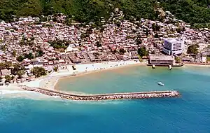 PR-111 on the Aguadilla pueblo coast
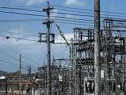 Electric plant on PR-111 in Bahomamey, San Sebastián
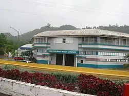 Ball park on PR-111 in Lares barrio
Major intersections
.jpg.webp) PR-111 at its junction with PR-422 in Moca
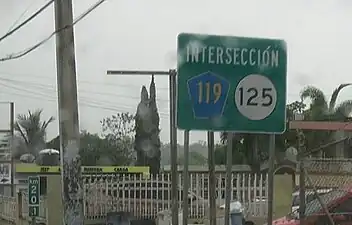
PR-111 at its junction with PR-422 in Moca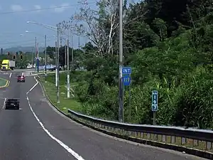 PR-111 near its junction with PR-119 in San Sebastián
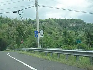
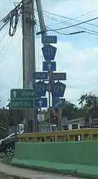 PR-111 at its junction with PR-129 in Lares
| Municipality | Location | km[2] | mi | Destinations | Notes |
|---|---|---|---|---|---|
| Aguadilla | Victoria | 0.0 | 0.0 | Western terminus of PR-111; partial cloverleaf interchange | |
| 0.3 | 0.19 | ||||
| Palmar | 1.2 | 0.75 | Seagull intersection | ||
| 1.7 | 1.1 | ||||
| 2.1 | 1.3 | ||||
| Moca | Pueblo | 3.3 | 2.1 | ||
| Moca barrio-pueblo | 4.8 | 3.0 | |||
| Moca barrio-pueblo–Pueblo line | 5.4– 5.5 | 3.4– 3.4 | |||
| Voladoras | 7.6 | 4.7 | |||
| 9.4 | 5.8 | ||||
| Capá | 11.9 | 7.4 | |||
| 12.7 | 7.9 | ||||
| San Sebastián | Hato Arriba | 14.1 | 8.8 | ||
| Hato Arriba–Guatemala line | 15.7 | 9.8 | |||
| Guatemala | 17.4– 17.5 | 10.8– 10.9 | |||
| 18.2– 18.3 | 11.3– 11.4 | ||||
| Bahomamey–Piedras Blancas line | 19.4– 19.5 | 12.1– 12.1 | |||
| Piedras Blancas | 20.9 | 13.0 | Former PR-111R | ||
| 21.3– 21.4 | 13.2– 13.3 | ||||
| 21.5– 21.6 | 13.4– 13.4 | ||||
| 22.3 | 13.9 | ||||
| Eneas–Cidral line | 24.0 | 14.9 | |||
| 25.1– 25.2 | 15.6– 15.7 | ||||
| 25.3– 25.4 | 15.7– 15.8 | ||||
| Eneas–Cidral– Magos tripoint | 26.0– 26.1 | 16.2– 16.2 | |||
| Lares | Pueblo | 30.3 | 18.8 | ||
| 31.9 | 19.8 | ||||
| 32.4 | 20.1 | ||||
| 32.7 | 20.3 | ||||
| Lares barrio-pueblo | 33.2 | 20.6 | |||
| 33.5 | 20.8 | ||||
| 34.6– 34.7 | 21.5– 21.6 | ||||
| 35.0 | 21.7 | ||||
| Lares | 35.2 | 21.9 | Western terminus of PR-129 concurrency; diamond interchange | ||
| 38.2 | 23.7 | Eastern terminus of PR-129 concurrency | |||
| 38.8 | 24.1 | ||||
| 40.2 | 25.0 | ||||
| Utuado | Angeles | 42.2 | 26.2 | ||
| 45.2 | 28.1 | ||||
| Caguana | 52.4 | 32.6 | |||
| 52.6 | 32.7 | Former PR-621 | |||
| Salto Arriba–Salto Abajo– Caguana tripoint | 55.6 | 34.5 | |||
| Salto Abajo | 59.7 | 37.1 | |||
| Utuado barrio-pueblo | 60.3 | 37.5 | Western terminus of PR-123 concurrency | ||
| 60.6 | 37.7 | Eastern terminus of PR-123 concurrency | |||
| Utuado barrio-pueblo–Viví Abajo– Salto Abajo tripoint | 62.0 | 38.5 | |||
| Utuado barrio-pueblo–Viví Abajo line | 63.8 | 39.6 | |||
| Viví Abajo | 65.1 | 40.5 | |||
| Las Palmas | 67.4 | 41.9 | Eastern terminus of PR-111 | ||
1.000 mi = 1.609 km; 1.000 km = 0.621 mi
| |||||
Related routes
Currently, PR-111 has three branches in its old segments in San Sebastián, Lares and Utuado, and previously had another in Aguadilla. Originally they were identified as PR-111R.[4] There are projects for Highway 111 listed on the Transportation Improvement Program for fiscal years 2017–2020, involving reconstructing, relocating and widening parts of the highway.[6]
Aguadilla loop
Highway 111 Spur | |
|---|---|
| Location | Aguadilla |
| Length | 1.6 km[7] (0.99 mi) |
Highway 111 Loop (Spanish: Carretera Ramal 111, abbreviated Ramal PR-111 or PR-111R) was a road that branched off from PR-111 to returning to its parent route in downtown Aguadilla. Currently the highway was renumbered to PR-1107P after PR-111 was replaced by PR-1107 through downtown area.[8][9] The entire route is located in Aguadilla barrio-pueblo, Aguadilla.
| km[7] | mi | Destinations | Notes | ||
|---|---|---|---|---|---|
| 1.6 | 0.99 | PR-111 south | Southern terminus of PR-111R; access to Moca; unsigned | ||
| 0.7 | 0.43 | PR-2 Spur east to PR-2 | One-way street; westbound access is via Calle Mercedes Moreno; access to Arecibo and Mayagüez; unsigned | ||
| 0.3 | 0.19 | One-way street; northern terminus of PR-440; southbound access is via Calle Ramón Echevarría | |||
| 0.0 | 0.0 | Northern terminus of PR-111R | |||
| 1.000 mi = 1.609 km; 1.000 km = 0.621 mi | |||||
San Sebastián spur
Highway 111 Spur | |
|---|---|
| Location | San Sebastián |
| Length | 1.2 km[10] (0.75 mi) |
Highway 111 Spur (Spanish: Carretera Ramal 111, abbreviated Ramal PR-111 or PR-111R) was a road that branched off from PR-111 to its junction with PR-119 and PR-125 in downtown San Sebastián. Currently the highway was renumbered to PR-125.[11][12] The entire route is located in Piedras Blancas, San Sebastián.
 PR-111R near its junction with PR-119 and PR-125
| km[10] | mi | Destinations | Notes | ||
|---|---|---|---|---|---|
| 0.0 | 0.0 | Western terminus of PR-111R | |||
| 1.2 | 0.75 | Eastern terminus of PR-111R | |||
| 1.000 mi = 1.609 km; 1.000 km = 0.621 mi | |||||
Puerto Rico Highway 1111
Highway 1111 | |
|---|---|
| Location | Lares |
| Length | 4.5 km[13] (2.8 mi) |
Puerto Rico Highway 1111 (PR-1111) is the old section of PR-111 through downtown Lares. This road can be seen as Puerto Rico 111 Business loop.[4] The entire route is located in Lares.
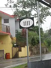 Puerto Rico Highway 1111 sign in Lares
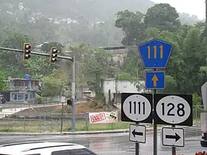 Puerto Rico Highways 1111, 128, 111 signs, in Lares
| Location | km[13] | mi | Destinations | Notes | |
|---|---|---|---|---|---|
| Pueblo | 0.0 | 0.0 | Western terminus of PR-1111 | ||
| Pueblo–Lares barrio-pueblo line | 0.7 | 0.43 | |||
| Lares barrio-pueblo | 1.6 | 0.99 | |||
| 3.0 | 1.9 | ||||
| 3.7 | 2.3 | ||||
| Lares barrio-pueblo–Lares line | 4.0– 4.1 | 2.5– 2.5 | |||
| Lares | 4.1 | 2.5 | |||
| 4.5 | 2.8 | Eastern terminus of PR-1111; dead end road | |||
| 1.000 mi = 1.609 km; 1.000 km = 0.621 mi | |||||
Puerto Rico Highway 4111
Highway 4111 | |
|---|---|
| Location | San Sebastián |
| Length | 0.90 km[14] (0.56 mi; 3,000 ft) |
Puerto Rico Highway 4111 (PR-4111) is an old segment of PR-111 that provides access to a small residential area in Piedras Blancas, San Sebastián, Puerto Rico.[4] The entire route is located in Piedras Blancas, San Sebastián.
 Puerto Rico Highway 4111 sign
| km[14] | mi | Destinations | Notes | ||
|---|---|---|---|---|---|
| 0.00 | 0.00 | Western terminus of PR-4111 | |||
| 0.90 | 0.56 | Eastern terminus of PR-4111 | |||
| 1.000 mi = 1.609 km; 1.000 km = 0.621 mi | |||||
Puerto Rico Highway 6111
Highway 6111 | |
|---|---|
| Location | Utuado |
| Length | 2.8 km[15] (1.7 mi) |
Puerto Rico Highway 6111 (PR-6111) is the original route of PR-111 through downtown Utuado. Like PR-1111, this road can be seen as Puerto Rico 111 Business loop.[4] The entire route is located in Utuado.
| Location | km[15] | mi | Destinations | Notes | |
|---|---|---|---|---|---|
| Utuado barrio-pueblo | 0.0 | 0.0 | Western terminus of PR-6111 | ||
| 0.8 | 0.50 | ||||
| Viví Abajo–Utuado barrio-pueblo line | 2.8 | 1.7 | Eastern terminus of PR-6111 | ||
| 1.000 mi = 1.609 km; 1.000 km = 0.621 mi | |||||
References
- "ps0996-18.pdf" (PDF). Cámara de Representantes de Puerto Rico (in Spanish). Retrieved 4 April 2019.
- Google (26 March 2020). "PR-111" (Map). Google Maps. Google. Retrieved 26 March 2020.
- "Lares, Memoria Núm. 60" (PDF). Puerto Rico Planning Board (in Spanish). 1955. Retrieved 4 August 2020.
- National Geographic Maps (2011). Puerto Rico (Map). 1:125,000. Adventure Map (Book 3107). Evergreen, Colorado: National Geographic Maps. ISBN 978-1566955188. OCLC 756511572.
- "Tránsito Promedio Diario (AADT)". Transit Data (Datos de Transito) (in Spanish). DTOP PR. p. 90. Archived from the original on 1 April 2019.
- "Transportation Improvement Program (TIP) Fiscal Year 2017-2020" (PDF). DTOP GOV.
- Google (26 April 2022). "PR-111R (Aguadilla)" (Map). Google Maps. Google. Retrieved 26 April 2022.
- "PR-111R, Barrio Pueblo". mapio.net. Retrieved 9 April 2023.
- "PR-111, Barrio Pueblo". mapio.net. Retrieved 9 April 2023.
- Google (26 April 2022). "PR-111R (San Sebastián)" (Map). Google Maps. Google. Retrieved 26 April 2022.
- "Avenida Emérito Estrada Rivera, San Sebastián, Puerto Rico". pr.geoview.info. Retrieved 9 April 2023.
- "Avenida Emérito Estrada Rivera, Piedras Blancas". Retrieved 9 April 2023.
- Google (1 March 2020). "PR-1111" (Map). Google Maps. Google. Retrieved 1 March 2020.
- Google (1 March 2020). "PR-4111" (Map). Google Maps. Google. Retrieved 1 March 2020.
- Google (1 March 2020). "PR-6111" (Map). Google Maps. Google. Retrieved 1 March 2020.
External links
 Media related to Puerto Rico Highway 111, Puerto Rico Highway 111R, Puerto Rico Highway 1111, Puerto Rico Highway 4111 and Puerto Rico Highway 6111 at Wikimedia Commons
- Repavimentarán la PR-111 (in Spanish)