Padang Pariaman Regency
Padang Pariaman Regency is a regency (kabupaten) of West Sumatra, Indonesia. It has an area of 1,343.09 km2, and it had a population of 390,204 at the 2010 census[2] and 430,626 at the 2020 census;[3] the official estimate as at mid 2022 was 436,129 - comprising 217,933 males and 218,196 females.[1] The regency seat is at the town of Parit Malintang. West Sumatra's capital and biggest city, Padang, is surrounded on the landward side by this regency.
Padang Pariaman Regency
Kabupaten Padang Pariaman | |
|---|---|
 Coat of arms | |
| Motto(s): Saiyo Sakato (Agree together, one voice together) | |
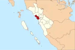 Location within West Sumatra | |
| Coordinates: 0.633333°S 100.117°E | |
| Country | Indonesia |
| Province | West Sumatra |
| Regency seat | Parit Malintang |
| Government | |
| • Regent | Ali Mukhni |
| • Vice Regent | Suhatri Bur |
| Area | |
| • Total | 1,343.09 km2 (518.57 sq mi) |
| Population (mid 2022 estimate)[1] | |
| • Total | 436,129 |
| • Density | 320/km2 (840/sq mi) |
| Time zone | UTC+7 (IWST) |
| Area code | (+62) 751 |
| Website | padangpariamankab.go.id |

Administrative districts
The regency is divided into seventeen districts (kecamatan), tabulated below with their areas and their populations at the 2010 census [2] and the 2020 census,[3] together with the official estimates as at mid 2022.[1] The table also includes the locations of the district administrative centres, the number of administrative villages (nagari) in each district, and its post code.
| Name of District (kecamatan) | Area in km2 | Pop'n census 2010 | Pop'n census 2020 | Pop'n estimate mid 2022 | Admin centre | No. of villages | Post code |
|---|---|---|---|---|---|---|---|
| Batang Anai | 164.68 | 44,013 | 52,844 | 54,409 | Pasar Usang | 8 | 25586 |
| Lubuak Aluang | 124.77 | 42,614 | 46,895 | 47,477 | Lubuak Aluang | 9 | 25581 |
| Sintuak Toboh Gadang | 32.65 | 17,710 | 19,268 | 19,464 | Sintuak | 5 | 25582 |
| Ulakan Tapakis | 23.01 | 18,910 | 20,652 | 20,878 | Ulakan | 8 | 25572 |
| Nan Sabaris | 66.21 | 26,730 | 30,035 | 30,531 | Pauah Kamba | 9 | 25571 |
| 2 x 11 Anam Lingkuang | 40.64 | 18,114 | 18,736 | 18,742 | Sicincin | 3 | 25584 |
| Anam Lingkuang | 34.64 | 18,845 | 20,609 | 20,840 | Pakandangan | 5 | 25583 |
| 2 x 11 Kayu Tanam | 188.55 | 25,558 | 28,051 | 28,385 | Kayu Tanam | 4 | 25585 |
| VII Koto Sungai Sariak | 63.42 | 33,595 | 35,524 | 35,688 | Sungai Sariak | 12 | 25576 |
| VII Koto Patamuan | 77.95 | 15,592 | 17,481 | 17,762 | Tandikek | 6 | 25574 |
| VII Koto Padang Sago | 34.93 | 7,940 | 8,674 | 8,769 | Padang Sago | 6 | 25573 |
| V Koto Kampuang Dalam | 66.91 | 22,523 | 23,690 | 23,775 | Kampuang Dalam | 8 | 25552 |
| V Koto Timur | 66.45 | 14,182 | 14,450 | 14,513 | Kudu Gantiang | 4 | 25575 |
| Sungai Limau | 90.36 | 27,781 | 29,774 | 29,988 | Sungai Limau | 4 | 25561 |
| Batang Gasan | 76.26 | 10,483 | 10,949 | 10,973 | Gasan Gadang | 3 | 25563 |
| Sungai Garinggiang | 107.73 | 29,009 | 32,021 | 32,438 | Singai Garinggiang | 4 | 25562 |
| IV Koto Aur Malintang | 84.29 | 17,457 | 20,973 | 21,497 | Batu Basa | 5 | 25564 |
| Totals | 1,343.09 | 390,204 | 430,626 | 436,129 | Parik Malintang | 103 |
Geography
Astronomical position Padang Pariaman which lies between 0 ° 11 '- 0 ° 49' south latitude and 98 ° 36 '- 100 ° 28' east longitude, with a total area of about 1,343.09 km ² and a coastline length of 60.50 km ². The regency's land area is equivalent to 3.15 percent of the total land area of West Sumatra Province.
Temperatures ranged between 24.4 °C - 25.7 °C, so for the average maximum temperature of 31.08 °C and average minimum temperature of 21.34 °C, with 86.75% relative humidity. Average rainfall for the district overall Pariaman in 2007 amounted to 368.4 mm, with an average days of rain as much as 19 days per month and the average wind speed is 2:14 knots / hour.
West Sumatra Province is a mountainous district nearly 3,000 metres in elevation made of Paleozoic sedimentary rock and Igneous rock that extends from the active row of volcanoes to the east. The Great Sumatran Fault divides the center of the province—the fault topography clearly visible—in a North-northwest to South-southeast direction. The stretch of land between the central mountain range and the shore is made of volcanic uplands and pyroclastic flow uplands with a narrow coastal plain distributed along the seacoast.
Towering above the eastern side (i.e. the mountain side) of Padang Pariaman are two large volcanoes; Gunung Tandikat stands at 2,347m and Gunung Singalang at 2,877m, together forming twin volcanoes. Lake Maninjau, located at the north end of Padang Pariaman, is a caldera lake measuring 20 kilometres north–south and 8 kilometres east–west which formed after a large volcanic burst 52,000 years ago. The volcanic products from this giant eruption are scattered over a wide area in the north-central area of Padang Pariaman. Today these volcanic products are seen as pyroclastic flow uplands and low relief hills.[4]
Earthquakes
Recent earthquakes that occurred along the Great Sumatran Fault that cuts across Sumatra are the series of quakes of 6 March 2007 measuring Mw6.4 and the Mw6.3 earthquake in the vicinity of Singkarak lake, which occurred in eastern Kabupaten Padang Pariaman.[5]
Notes
- Badan Pusat Statistik, Jakarta, 2023, Kabupaten Padang Pariaman Dalam Angka 2023 (Katalog-BPS 1102001.1305)
- Biro Pusat Statistik, Jakarta, 2011.
- Badan Pusat Statistik, Jakarta, 2021.
- "Sumatran Plate Boundary Project :: Scientific Papers". Tectonics.caltech.edu. Retrieved 2011-01-08.
- http://www.tectonics.caltech.edu/sumatra/downloads/papers/Shs.pdf
