Pakhribas Municipality
Pakhribas (Nepali: पाख्रीबास नगरपालिका) is an urban municipality out of three urban municipalities located in Dhankuta District of Province No. 1 of Nepal. Pakhribas municipality established on 2 December 2014 merging following VDCs: Pakhribas, Sanne, Phalate, Ghorlikharka and Muga.[1]
Pakhribas
पाख्रिवास | |
|---|---|
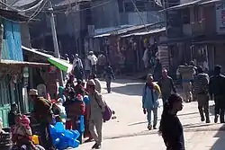 Pakhribas Bazaar | |
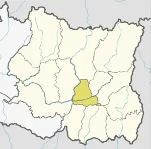
 Pakhribas Location in Koshi Province  Pakhribas Pakhribas (Nepal) | |
| Coordinates: 27.04°N 87.29°E | |
| Country | |
| Province | Koshi Province |
| District | Dhankuta District |
| Wards | 10 |
| Established | 2 December 2014 |
| Government | |
| • Mayor | Mr. Brish Bahadur Rai (NCP) |
| • Deputy Mayor | Ms. Devkala Paudel Timsina (NCP) |
| Population (2011) | |
| • Total | 22,078 |
| Time zone | UTC+5:45 (NST) |
| Postal code | 56809 |
| Area code | 026 |
| Website | www |
When the Government of Nepal decided to reduce local level body in 753 units, all previous VDCs nullified and merged them with either existed Municipalities or created new Municipality, so Chungmang VDC merged with Pakhribas on 10 March 2017.[1]
The total area of the municipality is 144.29 square kilometres (55.71 sq mi) and the total population of the municipality is 22078 as of 2011 Nepal census. The municipality is divided into total 10 wards.[2]
Demographics
At the time of the 2011 Nepal census, Pakhribas Municipality had a population of 22,078. Of these, 53.8% spoke Nepali, 14.4% Tamang, 13.4% Magar, 8.8% Rai, 3.0% Bantawa, 1.3% Phangduwali, 0.9% Gurung, 0.7% Limbu, 0.7% Yakkha, 0.6% Newar, 0.5% Nachhiring, 0.4% Athpare, 0.4% Maithili, 0.2% Sherpa, 0.1% Bhujel, 0.1% Dungmali, 0.1% Hindi, 0.1% Sampang, 0.1% Sign language and 0.2% other languages as their first language.[3]
In terms of ethnicity/caste, 27.2% were Chhetri, 16.4% Rai, 16.0% Tamang, 13.9% Magar, 5.8% Hill Brahmin, 4.7% Kami, 3.6% Newar, 2.4% Damai/Dholi, 2.0% Gharti/Bhujel, 2.0% Gurung, 1.9% Sarki, 1.6% Sanyasi/Dasnami, 0.7% Limbu, 0.4% Aathpariya, 0.3% Sherpa, 0.2% Yakkha, 0.1% Bantawa, 0.1% Dhunia, 0.1% Teli, 0.1% other Terai, 0.1% Yadav and 0.5% others.[4]
In terms of religion, 59.8% were Hindu, 26.3% Buddhist, 12.8% Kirati, 1.0% Christian and 0.2% others.[5]
In terms of literacy, 72.2% could read and write, 2.4% could only read and 25.4% could neither read nor write.[6]
Twin towns – sister cities
History Of Pakhribas
Pakhribas VDC
Pakhribas was a village development committee in Dhankuta District in the Kosi Zone of EDR before 2014. At the time of the 1991 Nepal census it had a population of 4508 people living in 890 individual households.[7] One story says that Pakhribas got its name from a Pakhri tree which used to stand at the center of the present day Pakhribas Bazaar some decades ago. The porters, transporting goods to Bhojpur and Sankhuwasabha, usually rested under the Pakhri tree and referred to the tree as their baas (lodge) for the night. Hence, the name Pakhribas. Pakhribas has 9 schools, among which three are private schools(Sheetala Devi English Secondary School at Pakhribas-7, Sayapatri English Medium School and Dibyajyoti English School at Pakhribas-3). Jalapa Devi Higher Secondary School provides higher education in science, humanities and arts faculty. Jalapa also has CTEVT annexed sub-overseer course. Pakhribas has three prominent Hindu shrines, one Buddhist monastery and two churches. The churches belong to the Protestant faith. Aashish Church situated in Pakhribas-8 is supposed to be the first of its kind in the Free Presbyterian faith.[8]
Climate
| Climate data for Pakhribas (elevation 1,680 m (5,510 ft), 1976–2005 normals) | |||||||||||||
|---|---|---|---|---|---|---|---|---|---|---|---|---|---|
| Month | Jan | Feb | Mar | Apr | May | Jun | Jul | Aug | Sep | Oct | Nov | Dec | Year |
| Average high °C (°F) | 14.4 (57.9) |
16.3 (61.3) |
20.5 (68.9) |
23.8 (74.8) |
24.1 (75.4) |
24.0 (75.2) |
23.3 (73.9) |
23.5 (74.3) |
23.0 (73.4) |
21.7 (71.1) |
19.1 (66.4) |
15.9 (60.6) |
20.8 (69.4) |
| Average low °C (°F) | 4.9 (40.8) |
6.4 (43.5) |
9.9 (49.8) |
12.8 (55.0) |
14.7 (58.5) |
17.0 (62.6) |
17.5 (63.5) |
17.4 (63.3) |
16.3 (61.3) |
13.2 (55.8) |
9.5 (49.1) |
6.4 (43.5) |
12.2 (53.9) |
| Average precipitation mm (inches) | 14.9 (0.59) |
14.5 (0.57) |
25.8 (1.02) |
61.0 (2.40) |
150.1 (5.91) |
261.7 (10.30) |
398.1 (15.67) |
344.0 (13.54) |
194.7 (7.67) |
63.4 (2.50) |
12.9 (0.51) |
12.9 (0.51) |
1,559.8 (61.41) |
| Source: Agricultural Extension in South Asia[9] | |||||||||||||
Pakhribas Municipality
Nowadays Pakhribas is a municipality.
Architecture and cityscape
Municipalities Information systems
Belbari Municipality is currently divided into 10 Wards.
| Ward Number | President | Contact Number | secretary | Contact Number |
|---|---|---|---|---|
| 1 | - | ९८५२०५०७१४ | हरि प्रसाद गौतम | ९८५२०५३६३३ |
| 2 | - | ९८४२३०४४७६ | ठगेन्द्र प्रसाद अधिकारी | ९८५२०५०९३० |
| 3 | - | ९८१६३११९८८ | रिता राई | ९८५२०६१५५४ |
| 4 | - | ९८५२०५३५१९ | इन्दु भुसाल | ९८४२३५०८०१ |
| 5 | - | ९८५२०५३५२० | संजय राई | ९८५२०५३९३३ |
| 6 | - | ९८५२०५३५१७ | शकुन्तला राई | ९८५२०७१४०० |
| 7 | - | ९८५२०५३६२२ | राजेन्द्र तामाङ्ग | ९८५२०५३५५० |
| 8 | - | ९८५२०५३८२२ | दिपेन्द्र गौतम | ९८५२०६१५५३ |
| 9 | - | ९८५२०६१७७५ | कमला पाण्डे | ९८५२०७७०४३ |
| 10 | - | ९८४२३८५९११ | दिनेशचन तिम्सिना | ९८५२०२१४९० |
Education
- College of Natural Resources Management (CNRM)
- Ram Madhyamik Biddhyalay, Muga
- Jalapa Madhyamik Biddhyalay, Pakhribas
- Amar Madhyamik Biddhyalay, Falate
Divisions
Pakhribas Municipality is divided into different formal VDC.
| No. | Type | Name | नेपाली |
|---|---|---|---|
| 1 | Formal VDC | Muga | मुगा |
| 2 | Formal VDC | Pakhribas | पाख्रीबास |
| 3 | Formal VDC | Chunwang | चुङ्बाङ |
| 4 | Formal VDC | Sanne | सान्ने |
| 5 | Formal VDC | Hathikharka | हाथिखर्क |
| 6 | Formal VDC | Falate | फलाटे |
Local Election
Local Level Election 2074
Not Available
Local Level Election 2079
| Party | Mayor/Chairperson | Deputy Mayor/Chairperson | Results |
|---|---|---|---|
| CPN (Unified Marxist–Leninist) | Bhim Bahadur Rai | Namrata Gautam | |
| Nepali Congress | Gyan Bahadur Gurung | - | |
| Communist Party of Nepal (Maoist Centre) | - | Om Prakash Niraula | |
| Rastriya Prajatantra Party | Gyan Bahadur Poudel | Rudra Kumari Ale | |
| Mangol National Organization | David Rai | - | |
| Independents | Chakendra Bahadur Basnet | - | |
| Independents | - | Dev Kumari Basnet |
Notable people
- Surya Bahadur Thapa
- Sunil Thapa
References
- "संक्षिप्त परिचय". www.pakhribasmun.gov.np. Pakhribas Municipality. Retrieved 30 May 2018.
- "स्थानीय तहहरूको विवरण". www.mofald.gov.np. MoFALD. Archived from the original on 31 August 2018. Retrieved 30 May 2018.
- NepalMap Language
- NepalMap Caste
- NepalMap Religion
- NepalMap Literacy
- "Nepal Census 2001". Nepal's Village Development Committees. Digital Himalaya. Retrieved 24 November 2008.
- "Pakhribas". Archived from the original on 17 October 2012. Retrieved 10 August 2012.
- "TEMPORAL AND SPATIAL VARIABILITY OF CLIMATE CHANGE OVER NEPAL (1976-2005)" (PDF). Agricultural Extension in South Asia. Archived from the original (PDF) on 13 October 2023. Retrieved 14 October 2023.
External links
![]() Media related to Pakhribas at Wikimedia Commons
Media related to Pakhribas at Wikimedia Commons