Panola, Oklahoma
Panola is a small unincorporated community and census-designated place in Latimer County, Oklahoma, United States. The post office was established March 18, 1911. Panola is the Choctaw name for cotton. The high school and gymnasium are on the National Register of Historic Places. The population was 73 at the time of the 2020 Census.[2]
Panola, Oklahoma | |
|---|---|
 Panola  Panola | |
| Coordinates: 34°55′43″N 95°12′48″W | |
| Country | United States |
| State | Oklahoma |
| County | Latimer |
| Area | |
| • Total | 1.13 sq mi (2.92 km2) |
| • Land | 1.12 sq mi (2.90 km2) |
| • Water | 0.01 sq mi (0.02 km2) |
| Elevation | 642 ft (196 m) |
| Population (2020) | |
| • Total | 73 |
| • Density | 65.12/sq mi (25.13/km2) |
| Time zone | UTC-6 (Central (CST)) |
| • Summer (DST) | UTC-5 (CDT) |
| FIPS code | 40-56950 |
| GNIS feature ID | 1096396 |
References
- "ArcGIS REST Services Directory". United States Census Bureau. Retrieved September 20, 2022.
- "Panola (CDP), Oklahoma". United States Census Bureau. Retrieved June 13, 2023.
External links
- Panola Public School District
- Oklahoma Digital Maps: Digital Collections of Oklahoma and Indian Territory
Municipalities and communities of Latimer County, Oklahoma, United States | ||
|---|---|---|
| City | 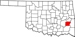 Latimer County map | |
| Towns | ||
| CDPs | ||
| Indian reservation | ||
| Footnotes | ‡This populated place also has portions in another county or counties | |
This article is issued from Wikipedia. The text is licensed under Creative Commons - Attribution - Sharealike. Additional terms may apply for the media files.