Parks, Nebraska
Parks is a namesake census-designated place in southern Dundy County, Nebraska, United States. As of the 2020 census, its population was 12.[3]
Parks, Nebraska | |
|---|---|
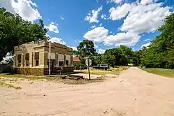 Main Street in Parks, July 2017 | |
 Parks Location within the state of Nebraska | |
| Coordinates: 40°02′37″N 101°43′30″W | |
| Country | United States |
| State | Nebraska |
| County | Dundy |
| Area | |
| • Total | 0.18 sq mi (0.46 km2) |
| • Land | 0.18 sq mi (0.46 km2) |
| • Water | 0.00 sq mi (0.00 km2) |
| Elevation | 3,104 ft (946 m) |
| Population (2020) | |
| • Total | 12 |
| • Density | 68.18/sq mi (26.33/km2) |
| Time zone | UTC-7 (Mountain (MST)) |
| • Summer (DST) | UTC-6 (MDT) |
| ZIP code | 69041 |
| FIPS code | 31-38365 |
| GNIS feature ID | 2583893[2] |
Description
Parks lies along local roads just north of U.S. Route 34, 12 miles (19 km) west of the city of Benkelman, the county seat of Dundy County.[4] Its elevation is 3,094 feet (943 m) above sea level.[5] Parks is unincorporated, with the ZIP code of 69041.[6] Google Maps did not bother with visiting Parks.
Parks was named and laid out in 1880–1881 by Frank Parks, who was the surveyor for the railroad that was moving west at the time.[7]
Notable person
- Roger L. Reisher, banker, philanthropist
References
- "ArcGIS REST Services Directory". United States Census Bureau. Retrieved September 18, 2022.
- U.S. Geological Survey Geographic Names Information System: Parks, Nebraska
- "Explore Census Data".
- Rand McNally. The Road Atlas '08. Chicago: Rand McNally, 2008, p. 62.
- U.S. Geological Survey Geographic Names Information System: Parks, Nebraska, Geographic Names Information System, 1979-03-09. Accessed 2008-04-26.
- Zip Code Lookup
- Chester Parks, grandson of Frank Parks
- "Census of Population and Housing". Census.gov. Retrieved June 4, 2016.
External links
Wikimedia Commons has media related to Parks, Nebraska.
Municipalities and communities of Dundy County, Nebraska, United States | ||
|---|---|---|
| City | Map of Nebraska highlighting Dundy County | |
| Village | ||
| CDPs | ||
| Unincorporated communities | ||
| Ghost town | ||
This article is issued from Wikipedia. The text is licensed under Creative Commons - Attribution - Sharealike. Additional terms may apply for the media files.