Patuakhali District
Patuakhali (Bengali: পটুয়াখালী, romanized: Potuakhali) is a district in South-central Bangladesh in the Barisal Division. This district is the main entrance for the beach of Kuakata.
Patuakhali
পটুয়াখালী | |
|---|---|
| Patuakhali District | |
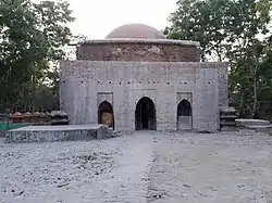 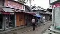  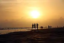 Clockwise from left-right: Majidbaria Shahi Mosque, Gazipur Bandar Bazar, Sonarchar Wildlife Sanctuary, Sunset at Kuakata Beach | |
| Nickname: সাগরকন্যা (Daughter of the Sea) | |
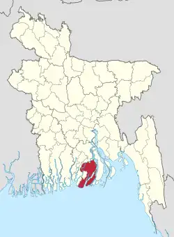 Location of Patuakhali in Bangladesh | |
Expandable map of Patuakhali District | |
| Coordinates: 22.3542°N 90.3181°E | |
| Country | |
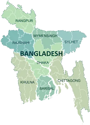
| Division | Barisal Division |
| Patuakhali | 1969 |
| Government | |
| • Deputy Commissioner | Mohammed Kamal Hosean [1] |
| Area | |
| • Total | 3,221.31 km2 (1,243.75 sq mi) |
| Population (2022 census)[2] | |
| • Total | 1,727,254 |
| • Density | 540/km2 (1,400/sq mi) |
| Time zone | UTC+06:00 (BST) |
| Postal code | 8600 |
| HDI (2018) | 0.586[3] medium · 16th of 21 |
| Website | www |
Geography
It is adjacent to the Bay of Bengal. The area of the district is 3220.15 km2.[4]
Patuakhali city is surrounded on three sides by rivers. The two major rivers are Laukathi and Lohalia, which are directly connected with the Bay of Bengal. The city has an inland airport used for transport and private travel across the country.
A number of different tribal peoples live in the district.
Subdistrict
There are 8 upazilas in this district. They are:
Administration
- Administrator of Zila Porishod: Mr. Khalilur Rahman Mohon[5]
- Deputy Commissioner (DC): MD. Matiul Islam Chawdhury
- Superintendent of Police (SP): Mr.Md.Shahidullah PPM
Economy
Agriculture is the profession of the most of the people. Fishing is also a prominent profession of this district. Thousands of boats go into the deep sea to fish and come back with tons of fish. Paddy, jute, and different types of vegetables are the main product of agriculture sector. Main sources of income Agriculture 57.05%, non-agricultural labourer 5.37%, industry 1.03%, commerce 13.79%, transport and communication 2.04%, service 9.22%, construction 2.13%, religious service 0.26%, rent and remittance 0.40% and others 8.71%.
Crops
Main Crops of Patuakhali district areas as follows:[6]
Fruits
The fruit trees indigenous to Patuakhali district areas as follows:[7]
- Mango
- Banana
- Guava
- Jamun
- Custard-apple or আতা
- Tamarind
- Grapefruit
- Lime
- Jackfruit
- Papaya
- Pineapple
- Bengal almond
- Lichi
- Pomegranate
- Palm or Tal
- Common fig
- Haritaki
- Date – scarce
- Coconut – scarce
Education
The literacy rate of Patuakhali is 54.1%; male 56.2% and female 52.0%. Educational institutions: university 1, agricultural and veterinary college 1, college 65, technical and vocational institutes 6, secondary school 288, primary school 1152, kindergarten 36, madrasa 506.[6]
- Universities
- Medical College
- Colleges
- Idris Molla Mahavidyalaya
- Patuakhali Govt College
- Patuakhali Government Womens College
- Bauphal Govt College
- Dr. Eakub Sharif Degree College
- Kalapara Govt College
- Janata College
- Rangabali Government College
- Schools
- Kalaia Secondary School
- Abdul High Bidda Nakeiton
- Patuakhali Government Jubilee High School
- Patuakhali Collectorate School and College
- Auliapur Adarsho Secondary School
- Patuakhali Government Girl's High School
- Kanakdia Sir Salimullah High School & college
- Madhya Madanpura Secondary School
- Polytechnic Institute
- Patuakhali Polytechnic Institute
- Begum Fazilatunnesa Polytechnic Institute
- Kanakdia Sir Salimullah High School
- Ayla Secondary School
Demographics
| Year | Pop. | ±% p.a. |
|---|---|---|
| 1974 | 937,006 | — |
| 1981 | 1,165,076 | +3.16% |
| 1991 | 1,273,872 | +0.90% |
| 2001 | 1,460,781 | +1.38% |
| 2011 | 1,535,854 | +0.50% |
| 2022 | 1,727,254 | +1.07% |
| Sources:[2][8] | ||
According to the 2022 Census of Bangladesh, Patuakhali District had 424,745 households and a population of 1,727,254, 18.6% of whom lived in urban areas. The population density was 536 people per km2. The literacy rate (age 7 and over) was 76.5%, compared to the national average of 74.7%.[2]
Religion
| Religion | Population (1941)[9]: 100–101 | Percentage (1941) | Population (2011)[8] | Percentage (2011) |
|---|---|---|---|---|
| Islam |
446,108 | 82.93% | 1,428,601 | 93.02% |
| Hinduism |
82,991 | 15.43% | 105,496 | 6.87% |
| Others [lower-alpha 2] | 8,806 | 1.64% | 1,757 | 0.11% |
| Total Population | 537,905 | 100% | 1,535,854 | 100% |
The district is overwhelmingly Muslim. Similar to other districts in the Barisal division, the minority Hindu and Christian populations have seen a decline in absolute numbers in the 2001-2011 period.[8] The district has 4765 mosques, 422 temples, and 13 churches.[6]
Patuakhali city
The city of Patuakhali is situated beside two local rivers: Laukathi River and Lohalia River. During high tides some of the regions of Patuakhali get flooded. The Bay of Bengal is not far from the region.

At the entrance of the city there is a bridge that connects Barisal (the divisional city) with Patuakhali and Kuakata Beach.
As Patuakhali is a coastal area, it is affected almost every year by natural disasters like cyclones, floods and tornadoes. To help the disaster-affected people, many NGO's are active in the area. They play a vital role in developing the life style of poor people.
Bura Ghuranga river view from the bank of Bura Ghuranga river in beside the Gazi Bhari, East Auliapur, Ronghopaldi, Arojbegi, Dhasmina.
Port of Payra
Port of Payra is planned to become the third sea port of Bangladesh (after Chittagong and Mongla).
Notable people
- A. K. M. Fazlul Haque, colorectal surgeon
- Abdul Hady Talukdar, academic
- Sohag Gazi, cricketer of the Bangladesh national cricket team
- KM Nurul Huda, Chief Election Commissioner of Bangladesh
- Faiz Ahmed, Senior Secretary, Member of Public Service Commission
- Nurul Haq Nur, joint-convenor of Bangladesh Sadharan Chhatra Adhikar Sangrakshan Parishad and vice-president, Dhaka University Central Students' Union
See also
Notes
- Patuakhali subdivision of Bakerganj district excluding the thanas Betagi, Barguna and Amtali
- Including Jainism, Christianity, Buddhism, Zoroastrianism, Judaism, Ad-Dharmis, or not stated
References
- "Mohammed Kamal Hosean". Patuakhali District. Retrieved 29 June 2021.
- Population and Housing Census 2022: Preliminary Report. Bangladesh Bureau of Statistics. August 2022. pp. viii, 29, 38, 45. ISBN 978-984-35-2977-0.
- "Sub-national HDI - Area Database - Global Data Lab". hdi.globaldatalab.org. Retrieved 18 March 2020.
- Jerin, Iffat (2012). "Patuakhali District". In Sirajul Islam; Miah, Sajahan; Khanam, Mahfuza; Ahmed, Sabbir (eds.). Banglapedia: the National Encyclopedia of Bangladesh (Online ed.). Dhaka, Bangladesh: Banglapedia Trust, Asiatic Society of Bangladesh. ISBN 984-32-0576-6. OCLC 52727562. OL 30677644M. Retrieved 25 October 2023.
- "AL men appointed administrators". The Daily Star. 16 December 2011. Retrieved 22 January 2020.
- "District Statistics 2011: Patuakhali" (PDF). Bangladesh Bureau of Statistics. Archived from the original (PDF) on 13 November 2014.
- Bangladesh District Gazetteers:Bogra. Government of Bangladesh. 1979, pp. 16–16
- "Zila Series: Patuakhali" (PDF). Bangladesh Population and Housing Census. Bangladesh Bureau of Statistics. 2011.
- "Census of India, 1941 Volume VI Bengal Province" (PDF). Retrieved 13 August 2022.
External links
| Upazila/Thana: | ||
|---|---|---|