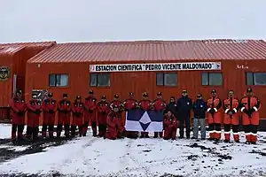
Maldonado Base
Maldonado Base, also Pedro Vicente Maldonado Base, is the Ecuadorian Antarctic research base situated at Guayaquil Bay, Greenwich Island. It is located in the South Shetland Islands, Antarctica. It opened in 1990. The area was visited by early 19th century sealers operating from nearby Clothier Harbour.
Maldonado Station | |
|---|---|
| Pedro Vincente Maldonado | |
 | |
 Maldonado Station Location of Maldonado Station in Antarctica | |
| Coordinates: 62°26′57″S 59°44′29″W | |
| Country | |
| Location in Antarctica | Greenwich Island South Shetland Islands Antarctica |
| Administered by | Instituto Antártico Ecuatoriano INAE |
| Established | 2 March 1990 |
| Elevation | 10 m (30 ft) |
| Population (2017)[1] | |
| • Summer | 32 |
| • Winter | 0 |
| Type | Seasonal |
| Period | Summer |
| Status | Operational |
| Activities | List
|
| Website | Instituto Antartico Ecuatoriano |
| Maldonado Range Front | |
| Markings | white (tower), black (stripe), yellow (daymark) |
| Power source | solar power |
| Focal height | 9 m (30 ft) |
| Range | 6 nmi (11 km; 6.9 mi) |
| Characteristic | Fl W 4s |
The base is named after the Spanish-American astronomer, topographer, and geographer Pedro Vicente Maldonado (1704–1748) born in Riobamba, present Ecuador.
There is a lighthouse near the base.[2]
Location
The base is located at 62°26′57″S 59°44′29″W which is 560 m south-southwest of Orión Point, 990 m southwest of Spark Point, 1.16 km north-northwest of Serrano Point and 2.56 km east-southeast of Agüedo Point (detailed Ecuadorian mapping in 2007, Bulgarian mapping in 2005 and 2009).
Maps
- L.L. Ivanov et al. Antarctica: Livingston Island and Greenwich Island, South Shetland Islands. Scale 1:100000 topographic map. Sofia: Antarctic Place-names Commission of Bulgaria, 2005.
- L.L. Ivanov. Antarctica: Livingston Island and Greenwich, Robert, Snow and Smith Islands. Scale 1:120000 topographic map. Troyan: Manfred Wörner Foundation, 2010. ISBN 978-954-92032-9-5 (First edition 2009. ISBN 978-954-92032-6-4)
See also
References
- Antarctic Station Catalogue (PDF) (catalogue). Council of Managers of National Antarctic Programs. August 2017. p. 69. ISBN 978-0-473-40409-3. Archived (PDF) from the original on 22 October 2022. Retrieved 16 January 2023.
- List of Lights, Pub. 111: The West Coasts of North and South America (Excluding Continental U.S.A. and Hawaii), Australia, Tasmania, New Zealand, and the Islands of the North and South Pacific Oceans (PDF). List of Lights. United States National Geospatial-Intelligence Agency. 2017.
- SCAR Composite Antarctic Gazetteer.
- Essy Santana and Jean Dumont. Granulometry of pebble beach ridges in Fort Williams Point, Greenwich Island, Antarctic Peninsula; a possible result from Holocene climate fluctuations. U.S. Geological Survey and The National Academies; USGS OF-2007-1047, Short Research Paper 027, 2007.
External links
- Instituto Antartico Ecuatoriano Archived 2020-01-26 at the Wayback Machine


.svg.png.webp)