Perito Moreno National Park
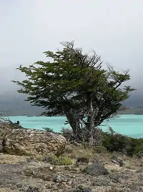
Perito Moreno National Park (Spanish: Parque Nacional Perito Moreno) is a national park in Argentina. It is located in the western region of Santa Cruz Province on the border with Chile. It has an area of 126,830 hectares of mountains and valleys at a height of 900 metres above sea level.
| Perito Moreno National Park | |
|---|---|
| Parque Nacional Perito Moreno | |
 Hypochaeris incana on the park's Belgrano peninsula | |
 | |
| Location | Santa Cruz Province, Argentina |
| Coordinates | 47°48′41″S 72°15′02″W |
| Area | 126.830 hectares |
| Established | 1937 |
History
The park is one of the oldest in Argentina having been established in 1937. It is named in honour of the explorer Francisco Moreno.
It was expanded in 2013 with a donation from Tompkins Conservation. The co-founder of Tompkins Conservation, Doug Tompkins first became intrigued by Perito Moreno National Park in 1968 as he passed by the area on a climbing expedition and saw Cerro San Lorenzo, Patagonia's second highest peak. He visited the park in 1991 with friends Yvon Chouinard and Rick Ridgeway and the following year negotiated the purchase of roughly 37,000-acres of private land within the park, which his organization managed as wildlife habitat and allowed to rewild. That tract was donated to the national parks administration in 2013.[1][2]
Geography
Climate
The park has a cold climate ranging from a wet climate in the west to a dry one in the east.[3] The park experiences strong and persistent westerly winds throughout the year.[3] Mean annual rainfall ranges from 3,000 mm (120 in) in the west to 400 mm (16 in) in the east.[3] Temperatures can fall below −25 °C (−13.0 °F) in winter.[3] During summer, the mean temperature is around 15 °C (59.0 °F).[3] Snowfalls can occur in every month.[3]
| Climate data for Paso del Águila (1937–1944) | |||||||||||||
|---|---|---|---|---|---|---|---|---|---|---|---|---|---|
| Month | Jan | Feb | Mar | Apr | May | Jun | Jul | Aug | Sep | Oct | Nov | Dec | Year |
| Record high °C (°F) | 28.3 (82.9) |
26.5 (79.7) |
23.8 (74.8) |
18.4 (65.1) |
16.4 (61.5) |
11.3 (52.3) |
10.5 (50.9) |
13.4 (56.1) |
16.0 (60.8) |
18.5 (65.3) |
21.8 (71.2) |
25.0 (77.0) |
28.3 (82.9) |
| Average high °C (°F) | 18.0 (64.4) |
16.6 (61.9) |
14.0 (57.2) |
10.3 (50.5) |
5.2 (41.4) |
1.3 (34.3) |
1.4 (34.5) |
2.2 (36.0) |
6.0 (42.8) |
10.2 (50.4) |
13.6 (56.5) |
15.8 (60.4) |
9.6 (49.3) |
| Daily mean °C (°F) | 11.3 (52.3) |
10.3 (50.5) |
8.6 (47.5) |
4.5 (40.1) |
0.8 (33.4) |
−3.0 (26.6) |
−2.9 (26.8) |
−2.4 (27.7) |
1.5 (34.7) |
4.9 (40.8) |
7.7 (45.9) |
9.7 (49.5) |
4.3 (39.7) |
| Average low °C (°F) | 4.8 (40.6) |
4.1 (39.4) |
2.3 (36.1) |
−0.2 (31.6) |
−3.6 (25.5) |
−7.2 (19.0) |
−7.1 (19.2) |
−6.4 (20.5) |
−2.9 (26.8) |
0.2 (32.4) |
1.9 (35.4) |
3.9 (39.0) |
−0.9 (30.4) |
| Record low °C (°F) | −7.0 (19.4) |
−6.4 (20.5) |
−8.0 (17.6) |
−9.0 (15.8) |
−12.0 (10.4) |
−19.0 (−2.2) |
−17.5 (0.5) |
−17.5 (0.5) |
−11.6 (11.1) |
−8.5 (16.7) |
−8.0 (17.6) |
−6.0 (21.2) |
−19.0 (−2.2) |
| Average precipitation mm (inches) | 13 (0.5) |
24 (0.9) |
27 (1.1) |
37 (1.5) |
53 (2.1) |
40 (1.6) |
13 (0.5) |
12 (0.5) |
10 (0.4) |
31 (1.2) |
20 (0.8) |
24 (0.9) |
304 (12.0) |
| Source: Secretaría de Aeronáutica (Servicio Meteorológico Nacional)[4] | |||||||||||||
Terrain

The park is located at around 900 metres above sea level, which is the height at which the valleys are inhabited. A series of mountain chains traverse the park from east to west and from north to south, resembling an imposing amphitheater. Inside the protected area the highest peak is cerro Heros (Heros hill) at 2,770 m. Nearby, but outside the boundary of the park lies the imposing cerro San Lorenzo (Monte San Lorenzo) which reaches 3,707 m in height,[5] which is generally covered by clouds. To the north of the lake Belgrano the cerro Leon (Lion hill) reaches 1,380 m and to the east of the same lake, the Gorra de Vasco (Basque peak) reaches 1,140 m. Inside the Park the Sierra Colorada (Red plain) is distinguished, of some 1,200 m, whose western slope is very abrupt, and whose coloring gives its name.
Hydrography
Two main basins are distinguished, one on the Pacific side and the other on the Atlantic. They comprise eight lakes including Belgrano Lake along with numerous rivers and streams.
The Pacific basin feeds into the lago Mogote (lake Mogote), which then flows into lago Volcán (lake Volcano).
The Atlantic basin features lago Burmeister (lake Burmeister) at 932 m. The many rivers in the basin traverse the Santa Cruz province and eventually reach the Atlantic to the east.
Flora and fauna
Of the 24 species of mammal that can be found in the park the most exotic and endangered species is the small wildcat gato pajero (Lynchailurus pajeros). Another small wildcat found within the park is the gato huiña (Oncifelis guigna) which is also endangered.
Other species include guanaco, puma (cougar), Patagonian fox, dwarf armadillo, ferret, skunk, tuco-tuco and south Andean deer.
A hundred and fifteen species of bird have been recorded in the park, including peregrine falcon, hooded grebe, flamingo, andean goose, Podiceps, and several species of ducks, falcons and eagles.
References
- "We believe the world can be more wild, beautiful, and equitable". Tompkins Conservation (in Spanish). Retrieved 2022-05-11.
- "37,500-acre El Rincon donated to expand Perito Moreno National Park | Patagonia´s Magazine: Patagon Journal". www.patagonjournal.com. Retrieved 2022-05-11.
- "Parque Nacional Perito Moreno" (in Spanish). Administración de Parques Nacionales. Retrieved November 7, 2015.
- "Anales Climatológicos" (PDF) (in Spanish). Servicio Meteorológico Nacional, Ministerio de Asuntos Técnicos (under NOAA Library).
- World Wildlife Fund; C. Michael Hogan. 2010. Magellanic subpolar forests. Encyclopedia of Earth, National Council for Science and the Environment. Washington DC
Further reading
- "Perito Moreno National Park" Photography by Antonio Vizcaíno. Contributors include Douglas Tompkins, Adolfo Fabricio Del Castillo, Eduardo Ramilo, Alejandro Serret, Rafael Smart, Emily Wakild, and Claudio Bertonatti. The Conservation Land Trust, 2014. ISBN 978-1939621184