Pesisir Selatan Regency
Pesisir Selatan Regency (Indonesian: Kabupaten Pesisir Selatan, Minangkabau: Kabupaten Pasisia Salatan, literally South Coast Regency) is a regency (kabupaten) of West Sumatra, Indonesia. It has an area of 6,049.33 km² and a population of 429,246 at the 2010 Census[2] and 504,418 at the 2020 Census;[3] the official estimate as at mid 2022 was 516,518.[1] The regency seat is at the town of Painan, in IV Jurai District.
Pesisir Selatan Regency
Kabupaten Pesisir Selatan | |
|---|---|
 Coat of arms | |
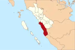 Location within West Sumatra | |
| Coordinates: 1.35°S 100.567°E | |
| Country | Indonesia |
| Province | West Sumatra |
| Regency seat | Painan |
| Government | |
| • Regent | Hendrajoni |
| • Vice Regent | Rusma Yul Anwar |
| Area | |
| • Total | 6,049.33 km2 (2,335.66 sq mi) |
| Population (mid 2022 estimate)[1] | |
| • Total | 516,518 |
| • Density | 85/km2 (220/sq mi) |
| Time zone | UTC+7 (IWST) |
| Area code | (+62) 751/756/757 |
| Website | pesisirselatankab.go.id |

Pesisir Selatan is located on the coast of West Sumatra and is bordered on the north by the city of Padang, in the east by the regencies of Solok Regency, South Solok Regency and by Kerinci Regency (in the province of Jambi) and in the south by Mukomuko Regency (Bengkulu province).
Pesisir Selatan is known for its traditional music, the Rabab Pesisir. The music includes the playing of a rebab (a stringed instrument), accompanied by one or more musicians singing.
Administrative districts
As at 2010 South Pesisir Regency consisted of twelve districts (kecamatan), but subsequently three additional districts have been created in the south by the splitting of each of the three existing districts in that sector. All these are tabulated below (listed from south to north, and grouped for convenience into three non-administrative sectors) with their areas and populations at the 2010 Census,[2] and the 2020 Census,[3] together with the official estimates as at mid 2022.[1] The table also includes the locations of the district administrative centres, the number of administrative villages (rural desa and urban kelurahan) in each district, and its postal codes.
| Name of District (kecamatan) | Area in km2 | Pop'n Census 2010 | Pop'n Census 2020 | Pop'n Estimate mid 2022 | Admin centre | No. of villages | Post codes |
|---|---|---|---|---|---|---|---|
| Silaut (a) | 466.45 | 12,109 | 15,592 | 16,152 | Silaut | 10 | 25675 |
| Lunang (a) | 456.73 | 18,341 | 22,423 | 23,228 | Lunang | 10 | 25674 |
| Basa Ampek Balai Tapan | 187.46 | (b) | 15,487 | 15,930 | Tapan | 10 | 25672 |
| Ranah Ampek Hulu Tapan | 281.96 | (b) | 15,499 | 15,943 | Pasar Beriang | 10 | 25670 |
| Pancung Soal | 547.41 | (c) | 26,570 | 27,355 | Inderapura | 10 | 25671 |
| Airpura | 380.10 | (c) | 18,180 | 18,718 | Tamuan | 10 | 25673 |
| Totals for southern sector | 2,320.11 | 93,194 | 113,751 | 117,326 | 60 | ||
| Linggo Sari Baganti (d) | 557.66 | 42,319 | 49,169 | 50,231 | Air Haji | 16 | 25668 |
| Ranah Pesisir | 562.44 | 30,089 | 33,760 | 34,257 | Balai Selasa | 10 | 25666 |
| Lengayang | 632.96 | 51,623 | 60,994 | 62,515 | Kambang | 9 | 25663 |
| Sutera (e) | 569.81 | 46,019 | 56,091 | 57,836 | Surantih | 12 | 25662 |
| Batang Kapas (f) | 277.54 | 30,829 | 36,422 | 37,329 | Pasar Kuok | 9 | 25661 |
| Totals for central sector | 2,600.41 | 200,879 | 236,436 | 242,168 | 56 | ||
| IV Jurai (g) | 368.19 | 43,302 | 50,894 | 52,110 | Salido | 20 | 25651 |
| Bayang (h) | 80.92 | 36,697 | 42,181 | 43,003 | Pasar Baru | 17 | 25652 |
| IV Nagari Bayang Utara | 242.33 | 7,276 | 8,286 | 8,432 | Asam Kumbang | 6 | 25653 |
| Koto XI Tarusan (j) | 437.37 | 47,898 | 52,870 | 53,479 | Nanggalo | 23 | 25654 |
| Totals for northern sector | 1,128.81 | 135,173 | 154,231 | 157,024 | 66 | ||
| Totals Regency | 6,049.33 | 429,246 | 504,418 | 516,518 | Painan | 182 |
Notes: (a) The former Lunang Silaut district had a population of 30,450 at the 2010 Census prior to its division into separate Lunang and Silaut districts.
(b) The Basa Ampek Balai Tapan district had a population of 25,742 at the 2010 Census prior to the splitting off of a separate Ranah Ampek Hulu Tapan district.
(c) The Pancung Soal district had a population of 37,002 at the 2010 Census prior to the splitting off of a separate Aipura district.
(d) including two small offshore islands. (e) including five small offshore islands. (f) including one small offshore island. (g) including nine small offshore islands, the largest being Pulau Aua Gadang (69 ha). (h) including seven small offshore islands, the largest being Pulau Babi (96 ha). (j) including 23 small offshore islands, the largest being Pulau Cubadak (705 ha) and Pulau Marak (256 ha).
Siamang rehabilitation
Marak Island is 7.37 kilometres from Nagari Sungai Pinang land which 500 hectares area has used as Siamang (Symphalangus syndactylus) and Owa ungko (Hylobates agilis) rehabilitation center complete with quarantine, medical, social and rehabilitation cages since 2003. The plan is to release some Siamang which have could use upper room with sufficient activities, not depend on human anymore and match with his/her spouse to Bukit Tiga Puluh National Park. The island is now home for 30 butterfly species and 50 kinds of birds, and is suitable for a conservation area.[4]
See also
References
- Badan Pusat Statistik, Jakarta, 2023, Kabupaten Pesisir Selatan Dalam Angka 2023 (Katalog-BPS 1102001.1301)
- Biro Pusat Statistik, Jakarta, 2011.
- Badan Pusat Statistik, Jakarta, 2021.
- "Owa dan Siamang Dilepasliarkan di Pulau Marak". Retrieved November 1, 2013.
