Pindamonhangaba
Pindamonhangaba is a municipality in the state of São Paulo, Brazil, located in the Paraíba Valley, between the two most active production and consumption regions in the country, São Paulo and Rio de Janeiro. It is accessible by the Via Dutra (BR-116 – SP-60 highway) at the 99th kilometer. This place name comes from the Old Tupi language meaning "where hooks are made" or, according to a different interpretation, "where the river bends".
Pindamonhangaba | |
|---|---|
| Município de Pindamonhangaba Municipality of Pindamonhangaba | |
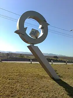
 Symbol of aluminum recycling in Pindamonhangaba, which is the largest center for recycling aluminum cans in Latin America.[2] | |
 Flag  Coat of arms | |
| Nickname: Princesa do Norte (Princess of North) | |
| Motto(s): | |
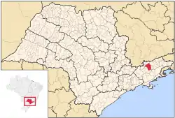
 Location in the state of São Paulo | |
 Pindamonhangaba Location in Brazil | |
| Coordinates: 22°55′26″S 45°27′42″W | |
| Country | |
| Region | Southeast |
| State | |
| Metropolitan Region | Vale do Paraíba e Litoral Norte |
| Founded | July 10, 1705 |
| Government | |
| • Mayor | Isael Domingues [3] (PR) (2017–2020) |
| Area | |
| • Total | 729.9 km2 (281.8 sq mi) |
| Elevation | 540 m (1,770 ft) |
| Population (2020 [4]) | |
| • Total | 170,132 |
| • Rank | 49st in state |
| • Density | 230/km2 (600/sq mi) |
| Demonym | Pindamonhangabense |
| Time zone | UTC−3 (BRT) |
| Postal Code (CEP) | 12400-000 |
| Area code | (+55) 12 |
| Website | Pindamonhangaba, SP |
Geography
- Estimated population (2020): 170,132 inhabitants
- Total area: 730.2 km2 (281.93 sq mi)
- Density (estimated 2020): 232.99 hab/km2 (608/sq mi)
- Population (Census 2010): 146,995 inhabitants
- Density (Census 2010): 201.39/km2 (531/sq mi)
- Altitude: 540 meters
- Tropical climate (Köppen CWA)
- Average annual temperature: 22.4 °C (72.3 °F)
History
The region then occupied by the Portuguese was Pindamonhangaba at least since July 22, 1643, registering more remote occupation by a certain Captain João Prado Martins. Six years later, on May 17, 1649, the area was formalized as a land grant and donated to the captain. It seems there is no information about what occurred between that date and August 12, 1672, so 13 years later, a chapel was built in honor of São José by brothers Antônio Bicudo Leme and Braz Esteves Leme. These brothers have acquired of the Countess of Vimieiro (Condesa de Vimieiro), the lands north of the town of Taubaté. There is no news of how the allotment had passed from the hands of Captain Prado Martins to the Countess. Given the uncertainties, two recent mayors of the city solved the problem by fiat: Caio Gomes Mayor officiated at the date of August 12, 1672 (Leme brothers) as the founding date of the city and later, Mayor João Bosco Nogueira decreed magna that date the county was founded was the date of emancipation, July 10, 1705.
Territorial evolution
On April 16, 1858, it lost part of the territory that was located in the Serra da Mantiqueira, turning into a new municipality São Bento do Sapucaí. Later it was fragmented into two new municipalities, Campos do Jordão and Santo Antônio do Pinhal. On November 30, 1944, it lost part of the territory to Aparecida, on its border, for the creation of the Roseira district, which two decades later became a city.
Notable people
- Luiz Gustavo, football player for Al Nassr.
- Éverson, football player for Atlético Mineiro.
- Matheus Salustiano, football player for Rio Claro Futebol Clube.
- Hilton Moreira, football player for Persipura Jayapura
- João Carlos de Oliveira, athlete, gold medal of triple jump in 1975 Pan American Games.
- Geraldo Alckmin, politician, governor of São Paulo from 2001 to 2006, and then again from 2011 to 2018.
- Ciro Gomes, politician, governor of Ceará from 1991 to 1994.
- Antônio Moreira César, Brazilian army officer.
References
- Brazil, the global leader in can recycling
- Brazil, the global leader in can recycling
- "Eleições 2016" (in Portuguese). eleicoes2016.com.br. Retrieved September 4, 2017.
- IBGE 2020