Pitakotte East Grama Niladhari Division
Pitakotte East Grama Niladhari Division is a Grama Niladhari Division of the Sri Jayawardanapura Kotte Divisional Secretariat of Colombo District of Western Province, Sri Lanka. It has Grama Niladhari Division Code 522A.
Pitakotte East | |
|---|---|
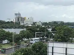
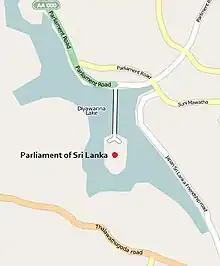
 Diyawanna Lake is located within, nearby or associated with the Pitakotte East Grama Niladhari Division | |
| Coordinates: 6.886763°N 79.912956°E | |
| Country | Sri Lanka |
| Province | Western Province |
| District | Colombo District |
| Divisional Secretariat | Sri Jayawardanapura Kotte Divisional Secretariat |
| Electoral District | Colombo Electoral District |
| Polling Division | Kotte Polling Division |
| Area | |
| • Total | 1.62 km2 (0.63 sq mi) |
| Elevation | 48 m (157 ft) |
| Population (2012)[2] | |
| • Total | 3,984 |
| • Density | 2,459/km2 (6,370/sq mi) |
| ISO 3166 code | LK-1124050 |
1987 grenade attack in the Sri Lankan Parliament, Diyasaru Park, Sri Lankan Parliament Building, Parliament of Sri Lanka and Diyawanna Lake are located within, nearby or associated with Pitakotte East.
Pitakotte East is a surrounded by the Battaramulla South, Pahalawela, Madiwela, Mirihana North, Pitakotte and Ethulkotte Grama Niladhari Divisions.
Demographics
Ethnicity
The Pitakotte East Grama Niladhari Division has a Sinhalese majority (91.2%). In comparison, the Sri Jayawardanapura Kotte Divisional Secretariat (which contains the Pitakotte East Grama Niladhari Division) has a Sinhalese majority (84.8%)[2]
Ethnicity in Pitakotte East[2]
Gallery
References
- "USGS EarthExplorer". earthexplorer.usgs.gov. U.S. Geological Survey. 2020.
- "Census of Population and Housing 2012" (PDF). statistics.gov.lk. Department of Census and Statistics, Sri Lanka. 2012.


