Platte Colony, South Dakota
Platte Colony is a Hutterite colony[4] and census-designated place (CDP) in Charles Mix County, South Dakota, United States. It was first listed as a CDP prior to the 2020 census.[2] The population of the CDP was 299 at the 2020 census.[5]
Platte Colony, South Dakota | |
|---|---|
 Platte Colony  Platte Colony | |
| Coordinates: 43°28′04″N 99°07′34″W | |
| Country | United States |
| State | South Dakota |
| County | Charles Mix |
| Area | |
| • Total | 0.31 sq mi (0.80 km2) |
| • Land | 0.31 sq mi (0.80 km2) |
| • Water | 0.00 sq mi (0.00 km2) |
| Elevation | 1,706 ft (520 m) |
| Population | |
| • Total | 299 |
| • Density | 970.78/sq mi (374.64/km2) |
| Time zone | UTC-6 (Central (CST)) |
| • Summer (DST) | UTC-5 (CDT) |
| ZIP Code | 57369 (Platte) |
| Area code | 605 |
| FIPS code | 46-50310 |
| GNIS feature ID | 2813004[2] |
It is in the northwest corner of the county, 20 miles (32 km) northwest of Platte, the nearest incorporated place. It is 2 miles (3 km) northeast of Lake Francis Case, a reservoir on the Missouri River.
References
- "ArcGIS REST Services Directory". United States Census Bureau. Retrieved October 15, 2022.
- U.S. Geological Survey Geographic Names Information System: Platte Colony, South Dakota
- "Census Population API". United States Census Bureau. Retrieved October 15, 2022.
- Friesen, Bert (May 2021). "Platte Hutterite Colony (Platte, South Dakota, USA)". Global Anabaptist Mennonite Encyclopedia Online. Retrieved September 10, 2021.
- "U.S. Census Bureau: Platte Colony CDP, South Dakota". www.census.gov. United States Census Bureau. Retrieved February 5, 2022.
- "Census of Population and Housing". Census.gov. Retrieved June 4, 2016.
Municipalities and communities of Charles Mix County, South Dakota, United States | ||
|---|---|---|
| Cities | 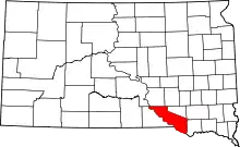 | |
| Towns | ||
| CDPs | ||
| Other communities | ||
| Indian reservation | ||
This article is issued from Wikipedia. The text is licensed under Creative Commons - Attribution - Sharealike. Additional terms may apply for the media files.