Podbukovje, Trebnje
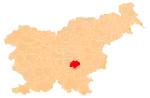
Podbukovje (pronounced [pɔdˈbuːkɔu̯jɛ], German: Podbukuje[2][3]) is a former village in eastern Slovenia in the Municipality of Trebnje. It is now part of the village of Arčelca.[4] It is part of the traditional region of Lower Carniola and is now included in the Southeast Slovenia Statistical Region.
Podbukovje | |
|---|---|
 Podbukovje Location in Slovenia | |
| Coordinates: 45°52′52″N 14°54′10″E | |
| Country | |
| Traditional region | Lower Carniola |
| Statistical region | Southeast Slovenia |
| Municipality | Trebnje |
| Elevation | 407 m (1,335 ft) |
Geography
Podbukovje is located northwest of the village center of Arčelca. It is connected by a side road to Orlaka to the west. Birch Peak (Slovene: Brezov vrh, elevation: 537 meters or 1,762 feet) rises above the settlement to the southwest.[1]
History
Podbukovje was annexed by Arčelca in 1953, ending its existence as a separate settlement.[5]
References
- Krajevni leksikon Dravske Banovine. 1937. Ljubljana: Zveza za tujski promet za Slovenijo, p. 483.
- "Uebersicht der in Folge a. h. Entschließung vom 26. Juli 1849 genehmigten provisorischen Gerichtseintheilung des Kronlandes Krain". Intelligenzblatt zur Laibacher Zeitung. No. 141. November 24, 1849. p. 46.
- Special-Orts-Repertorium von Krain. Vienna: Alfred Hölder. 1884. p. 121.
- Savnik, Roman (1971). Krajevni leksikon Slovenije, vol. 2. Ljubljana: Državna založba Slovenije. p. 592.
- Marinković, Dragan (1991). Abecedni spisak naselja u SFRJ. Promene u sastavu i nazivima naselja za period 1948–1990. Belgrade: Savezni zavod za statistiku. pp. 1, 77.
External links
This article is issued from Wikipedia. The text is licensed under Creative Commons - Attribution - Sharealike. Additional terms may apply for the media files.