Potomac Park, Maryland
Potomac Park (ⓘ) is an unincorporated subdivision and census-designated place (CDP) located on the North Branch Potomac River in Allegany County, Maryland, United States. As of the 2010 census, it had a population of 2,530.[3] Potomac Park lies along U.S. Route 220 (McMullen Highway) between Cresaptown and Cumberland. The CDP of Bowling Green is immediately to the north on Route 220.
Potomac Park, Maryland | |
|---|---|
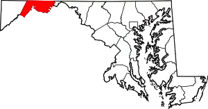
 Location within the State of Maryland  Potomac Park, Maryland (the United States) | |
| Coordinates: 39°36′42″N 78°48′21″W | |
| Country | |
| State | |
| County | |
| Area | |
| • Total | 0.39 sq mi (1.00 km2) |
| • Land | 0.39 sq mi (1.00 km2) |
| • Water | 0.00 sq mi (0.00 km2) |
| Elevation | 720 ft (220 m) |
| Population (2020) | |
| • Total | 821 |
| • Density | 2,126.94/sq mi (821.91/km2) |
| Time zone | UTC−5 (Eastern (EST)) |
| • Summer (DST) | UTC−4 (EDT) |
| ZIP code | 21502[2] |
| Area code(s) | 240 and 301 |
| FIPS code | 24-63425 |
| GNIS feature ID | 2583675 |
Within the boundaries of the community are the Allegany County Fairgrounds and the Western Correctional Institution.
References
- "2020 U.S. Gazetteer Files". United States Census Bureau. Retrieved April 26, 2022.
- "Potomac Park MD ZIP Code". zipdatamaps.com. 2023. Retrieved April 18, 2023.
- "Geographic Identifiers: 2010 Demographic Profile Data (G001): Potomac Park CDP, Maryland". U.S. Census Bureau, American Factfinder. Archived from the original on February 12, 2020. Retrieved May 23, 2013.
- "Census of Population and Housing". Census.gov. Retrieved June 4, 2016.
Wikimedia Commons has media related to Potomac Park, Maryland.
This article is issued from Wikipedia. The text is licensed under Creative Commons - Attribution - Sharealike. Additional terms may apply for the media files.