Řeporyje
Řeporyje is a cadastral area of Prague. Most of it belongs to the municipal district of the same name, the rest belonging to Prague 13. Řeporyje became part of Prague in 1974, before which it was recorded as a městys.
Řeporyje | |
|---|---|
Municipal District of Prague Cadastral Area of Prague | |
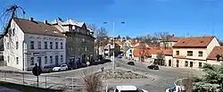 Řeporyje town square | |
 Flag  Coat of arms | |
 Řeporyje 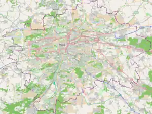 Řeporyje | |
| Coordinates: 50°1′59″N 14°18′42″E | |
| Country | Czech Republic |
| Region | The Capital City of Prague |
| Government | |
| • Mayor | Pavel Novotný (ODS) |
| Area | |
| • Total | 9.87 km2 (3.81 sq mi) |
| Population (2021) | |
| • Total | 4,729[1] |
| Time zone | UTC+1 (CET) |
| • Summer (DST) | UTC+2 (CEST) |
| Postal code | 155 00 |
| Website | http://www.prahareporyje.cz |
The district is situated on Dalejský potok and borders Prokopské údolí to the east. The western part of Řeporyje is an industrial area, marked by the visually prominent silo belonging to Soufflet Agro a.s. The district is served by Praha-Řeporyje railway station, a passing point on the Praha – Rudná – Beroun railway line.
Global stratigraphic boundary
Řeporyje is home of a global stratigraphic boundary for the Silurian. The base boundary for the Přídolí epoch and stage is located in a quarry southwest of Řeporyje (50.0277°N 14.3249°E).
Gallery
 Viaduct over Dalejský potok
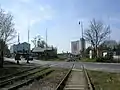 The passing loop before Praha-Řeporyje station
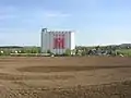 Soufflet Agro silo
Demographics
| Year | Pop. | ±% |
|---|---|---|
| 1869 | 525 | — |
| 1880 | 682 | +29.9% |
| 1890 | 899 | +31.8% |
| 1900 | 1,411 | +57.0% |
| 1910 | 1,823 | +29.2% |
| 1921 | 1,880 | +3.1% |
| 1930 | 2,816 | +49.8% |
| 1950 | 2,949 | +4.7% |
| 1961 | 2,942 | −0.2% |
| 1970 | 2,399 | −18.5% |
| 1980 | 2,559 | +6.7% |
| 1991 | 2,122 | −17.1% |
| 2001 | 2,174 | +2.5% |
| 2011 | 3,727 | +71.4% |
| 2021 | 4,729 | +26.9% |
| Source: Censuses[3] | ||
References
- https://www.czso.cz/csu/czso/vysledky-scitani-2021-otevrena-data
- "Гостомель та район чеської Праги – Ржепоріє стали містами-побратимами". Децентралізація (in Ukrainian). 2023-03-02. Retrieved 2023-06-24.
- "Historický lexikon obcí České republiky 1869–2011 – Praha" (in Czech). Czech Statistical Office. 2015-12-21. pp. 7–8.
External links
This article is issued from Wikipedia. The text is licensed under Creative Commons - Attribution - Sharealike. Additional terms may apply for the media files.