Promontorium Taenarium
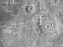
Promonontorium Taenarium is on the mid-lower left of the LRO image
Promontorium Taenarium is a headland on the near side of the Moon. It is located in the eastern end of Mare Nubium. Its length is about 70 km. Its coordinates are 18°39′0″S 7°28′24″W.[1]
The name Promontorium Taenarium was first used by Johannes Hevelius in his 1647 map of the Moon, but this refers to a bright point at crater Guericke B.[2] Taenarium refers to Cape Tainaron (known as Cape Matapan), the southernmost point of the Peloponnese peninsula of Greece.[1]
References
- "Promontorium Taenarium". Gazetteer of Planetary Nomenclature. USGS Astrogeology Research Program.
- Ewen A. Whitaker, Mapping and Naming the Moon (Cambridge University Press, 1999), p. 208.
External links
Wikimedia Commons has media related to Promontorium Taenarium.
- Promontorium Taenarium at Moon Wiki
- Wood, Chuck (July 27, 2004). "Obliquely Viewed Fault". Lunar Photo of the Day. - features the promontory

This article is issued from Wikipedia. The text is licensed under Creative Commons - Attribution - Sharealike. Additional terms may apply for the media files.