Purau
Purau is a small town in Canterbury, New Zealand, facing Lyttelton Harbour.
Purau | |
|---|---|
 Purau | |
| Coordinates: 43°38′30.44″S 172°45′8.23″E | |
| Country | New Zealand |
| Region | Canterbury Region |
| District | Christchurch City |
| Ward | Banks Peninsula |
| Community | Te Pātaka o Rākaihautū Banks Peninsula |
| Electorates |
|
| Government | |
| • Territorial Authority | Christchurch City Council |
| • Regional council | Environment Canterbury |
| • Mayor of Christchurch | Phil Mauger |
| • Banks Peninsula MP | Vanessa Weenink |
| • Te Tai Tonga MP | Tākuta Ferris |
| Area | |
| • Total | 0.21 km2 (0.08 sq mi) |
Geography
Purau is located on Banks Peninsula, one of the southern bays forming Lyttelton Harbour.
History
Purau has a long history of Māori settlement. Ngāti Māmoe lived here prior to Ngāi Tahu settling the bay. There are many Māori burial sites in the area.[2]
European occupation started in 1843, when the Greenwood brothers started a farm here. They sold to the Rhodes brothers in 1847 (William Barnard and George, with the latter taking over management of the station).[3][4] When Robert Heaton Rhodes, another of the Rhodes brothers, came to New Zealand in 1850, he took over Purau.[5]
Demographics
Purau is described by Statistics New Zealand as a rural settlement, and covers 0.21 km2 (0.081 sq mi).[1] It had an estimated population of as of June 2023,[6] with a population density of Formatting error: invalid input when rounding people per km2. It is part of the Eastern Bays-Banks Peninsula SA2 statistical area.[7]
| Year | Pop. | ±% p.a. |
|---|---|---|
| 2006 | 63 | — |
| 2013 | 51 | −2.97% |
| 2018 | 69 | +6.23% |
| Source: [8] | ||
Purau had a population of 69 at the 2018 New Zealand census, an increase of 18 people (35.3%) since the 2013 census, and an increase of 6 people (9.5%) since the 2006 census. There were 33 households, comprising 33 males and 33 females, giving a sex ratio of 1.0 males per female. The median age was 52.5 years (compared with 37.4 years nationally), with 9 people (13.0%) aged under 15 years, 6 (8.7%) aged 15 to 29, 39 (56.5%) aged 30 to 64, and 15 (21.7%) aged 65 or older.
Ethnicities were 95.7% European/Pākehā, 13.0% Māori, and 4.3% Pasifika. People may identify with more than one ethnicity.
Although some people chose not to answer the census's question about religious affiliation, 47.8% had no religion, 26.1% were Christian and 4.3% had other religions.
Of those at least 15 years old, 18 (30.0%) people had a bachelor's or higher degree, and 6 (10.0%) people had no formal qualifications. The median income was $32,500, compared with $31,800 nationally. 9 people (15.0%) earned over $70,000 compared to 17.2% nationally. The employment status of those at least 15 was that 27 (45.0%) people were employed full-time, 12 (20.0%) were part-time, and 3 (5.0%) were unemployed.[8]
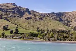
Gallery
 Panorama of Purau Bay
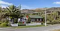 A house in Purau
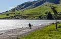 Beach
Beach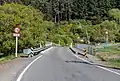 Bridge across Purau Stream
References
- "ArcGIS Web Application". statsnz.maps.arcgis.com. Retrieved 14 October 2021.
- "Purau". Christchurch City Libraries. Retrieved 24 June 2012.
- McLintock, A. H. (1966). "Rhodes Brothers". An Encyclopaedia of New Zealand. Retrieved 24 June 2012.
- Leopold George Dyke Acland (1946). "Land Tax And Advances To Settlers' Department". The Early Canterbury Runs: Containing the First, Second and Third (new) Series. Christchurch: Whitcombe and Tombs Limited. Retrieved 22 June 2012.
- Pinney, Robert. "George Rhodes". Dictionary of New Zealand Biography. Ministry for Culture and Heritage. Retrieved 23 April 2017.
- "Subnational population estimates (RC, SA2), by age and sex, at 30 June 1996-2023 (2023 boundaries)". Statistics New Zealand. Retrieved 25 October 2023. (regional councils); "Subnational population estimates (TA, SA2), by age and sex, at 30 June 1996-2023 (2023 boundaries)". Statistics New Zealand. Retrieved 25 October 2023. (territorial authorities); "Subnational population estimates (urban rural), by age and sex, at 30 June 1996-2023 (2023 boundaries)". Statistics New Zealand. Retrieved 25 October 2023. (urban areas)
- 2018 Census place summary: Eastern Bays-Banks Peninsula
- "Statistical area 1 dataset for 2018 Census". Statistics New Zealand. March 2020. 7026638.