Jacabamba
Jacabamba[2][1] (possibly from Quechua qaqa rock, pampa a large plain,[3] "rock plain") is a 5,566-metre-high (18,261 ft) mountain in the Cordillera Blanca in the Andes of Peru.[4] It is situated in the Ancash Region, Asunción Province, Chacas District, in the Carhuaz Province, Marcará District, and in the Huari Province, Huari District. Jacabamba lies between mount Copap to the north and Chinchey to the south.[4] Lake Rurichinchay lies at its feet.[2][4]
| Jacabamba | |
|---|---|
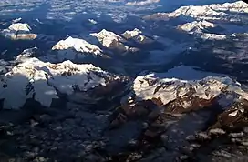
 Aerial view of the Cordillera Blanca as seen from the east with Jacabamba in the center (the one with three spots of snow on its eastern slope) | |
| Highest point | |
| Elevation | 5,566 m (18,261 ft)[1] |
| Coordinates | 9°19′19″S 77°19′15″W |
| Geography | |
 Jacabamba Peru | |
| Location | Peru, Ancash Region |
| Parent range | Andes, Cordillera Blanca |
The rivers Jacabamba and Rurichinchay originate on the east side of the mountain and flow to the south-west.[2][4] They belong to the watershed of the Marañón River.[1]
References
- escale.minedu.gob.pe - UGEL map of the Asunción Province (Ancash Region)
- Peru 1:100 000, Huari (19-i). IGN (Instituto Geográfico Nacional - Perú).
- Teofilo Laime Ajacopa (2007). Diccionario Bilingüe: Iskay simipi yuyayk’anch: Quechua – Castellano / Castellano – Quechua (PDF). La Paz, Bolivia.
{{cite book}}: CS1 maint: location missing publisher (link) - Alpenvereinskarte 0/3b. Cordillera Blanca Süd (Peru). 1:100 000. Oesterreichischer Alpenverein. 2005. ISBN 3-937530-05-3.
This article is issued from Wikipedia. The text is licensed under Creative Commons - Attribution - Sharealike. Additional terms may apply for the media files.