Carhuaz Province
The Carhuaz Province is one of twenty provinces of the Ancash Region of Peru.
Carhuaz[1] | |
|---|---|
 | |
 Flag  Coat of arms | |
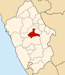
 Location of Carhuaz in the Ancash Region | |
| Country | Peru |
| Region | Ancash |
| Capital | Carhuaz |
| Government | |
| • Mayor | Pablo Pedro Julca Chávez (2019-2022) |
| Area | |
| • Total | 804 km2 (310 sq mi) |
| Population | |
| • Total | 45,184 |
| • Density | 56/km2 (150/sq mi) |
| Website | www |
Geography
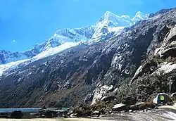
The Cordillera Blanca traverses the province. Waskaran, its highest elevation, lies on the border to the Yungay Province. Pallqarahu, Pukaranra, Qupa, Tuqllarahu, Wallqan and Yanarahu belong to the highest peaks of the province. Other mountains are listed below:[4]
- Chiqllarahu
- Hatun Qiqa
- Hatun Qutu
- Kuntur Wayin
- Llika Mach'ay
- Minuyu
- Paqtsarahu
- Paqtsaruri
- Perlilla
- Pumapampa
- Qaqapampa
- Q'awa Qutu
- Rurichinchay
- Saywan Punta
- T'uruq Punta
- Uchpay
- Wamanripa
- Wantu Hirka
- Warmi Qucha
- Wathiya Qutu
- Wiñaq
- Yana Qucha
- Yana Qutu
- Yanarahu
Political division
Carhuaz is divided into eleven districts, which are:
Ethnic groups
The people in the province are mainly indigenous citizens of Quechua descent. Quechua is the language which the majority of the population (73.27%) learnt to speak in childhood, 26.47% of the residents started speaking using the Spanish language (2007 Peru Census).[5]
References
- (in Spanish) http://www.municarhuaz.gob.pe/
- (in Spanish) http://www.municarhuaz.gob.pe/
- (in Spanish) http://www.municarhuaz.gob.pe/
- escale.minedu.gob.pe - UGEL map of the Carhuaz Province (Ancash Region)
- inei.gob.pe Archived January 27, 2013, at the Wayback Machine INEI, Peru, Censos Nacionales 2007
External links
- (in Spanish) Official website of the Carhuaz Province
- (in Spanish) Official website of the San Miguel de Aco District
This article is issued from Wikipedia. The text is licensed under Creative Commons - Attribution - Sharealike. Additional terms may apply for the media files.