Quakertown, Pennsylvania
Quakertown is a borough in Bucks County, Pennsylvania, United States. As of 2020, it had a population of 9,359.[3] The borough is 15 miles (24 km) south of Allentown and Bethlehem and 40 miles (64 km) north of Philadelphia, making Quakertown a border town of both the Delaware Valley and Lehigh Valley metropolitan areas.
Quakertown, Pennsylvania | |
|---|---|
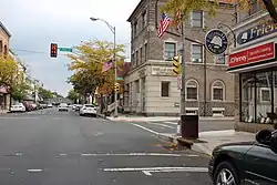 Broad Street in Quakertown, September 2012 | |
 Seal | |
| Etymology: the "Quakers" | |
| Motto: "The Heart of Upper Bucks County!" | |
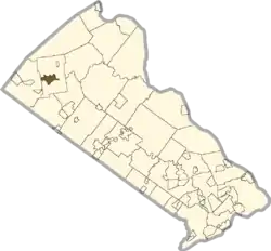 Location of Quakertown in Bucks County, Pennsylvania. | |
 Quakertown Location of Quakertown in Pennsylvania  Quakertown Quakertown (the United States) | |
| Coordinates: 40°26′26″N 75°20′26″W | |
| Country | United States |
| State | Pennsylvania |
| County | Bucks |
| Government | |
| • Type | Council-manager |
| • Council President | Donald E. Rosenberger (R) |
| Area | |
| • Total | 2.04 sq mi (5.27 km2) |
| • Land | 2.04 sq mi (5.27 km2) |
| • Water | 0.00 sq mi (0.00 km2) |
| Elevation | 505 ft (154 m) |
| Population | |
| • Total | 9,359 |
| • Density | 4,599.02/sq mi (1,775.87/km2) |
| Time zone | UTC−5 (EST) |
| • Summer (DST) | UTC−4 (EDT) |
| ZIP Code | 18951 |
| Area codes | 215, 267, 445 |
| Website | quakertown.org |
Quakertown is considered part of the United States Census Bureau's Philadelphia−Camden−Wilmington (PA−NJ−DE-MD) MSA and the Delaware Valley. Richland Township sorrounds Quakertown
Quakertown is located 15.7 miles (25.3 km) south of Allentown and 47.4 miles (76.3 km) northwest of Philadelphia.
History
Quaker settlement
Quakertown was originally settled by members of the Religious Society of Friends, or Quakers. The settlement was not officially known as Quakertown until its first post office opened in 1803.[4]
Liberty Bell moved
On September 18, 1777, during the American Revolutionary War, a convoy of wagons carrying the Liberty Bell from Philadelphia to Allentown, under the command of Col. Thomas Polk of Charlotte, North Carolina, stopped in Quakertown. The Liberty Bell was stored overnight behind the home of Evan Foulke (1237 West Broad Street), and the entourage stayed at the Red Lion Inn. The John Fries' Rebellion was also started in the Red Lion Inn in 1799.
1800s growth
In 1854, Quakertown elected its first Burgess. The North Pennsylvania Railroad facilitated access to the area, which brought about a great increase in population, and by 1880, the population of Quakertown had almost reached 1,800.[4]
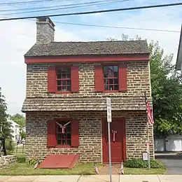
Liberty Hall, Quakertown Historic District, Quakertown Passenger and Freight Station, and Enoch Roberts House are listed on the National Register of Historic Places.[5]
Industry and population
The Civil War, along with national economic expansion, changed Quakertown from a tiny village to a commercial manufacturing center. In the nineteenth century, local industrial establishments included cigar and cigar box factories, silk mills, harness factories, and stove foundries. Until 1969, Quakertown generated its own electrical power. As of 2022, Quakertown has extensive mall development along Pennsylvania Route 309 that includes many restaurants, businesses, and retail outlets. The population of Quakertown in 1900 was 3,014; it rose to 3,801 in 1910. By 1940, the population had reached 5,150 people. At the 2010 census, the borough's population was 8,979.
Interurban to Allentown and Philadelphia
From 1901 to 1951, Quakertown was an hourly stop on the Lehigh Valley Transit Company's electric interurban trolley line from Allentown and Coopersburg through Quakertown then south through Perkasie, Sellersville, Souderton, Lansdale, and Norristown to Philadelphia. With car use limited during World War II due to gasoline rationing, the trolley line moved a very large number of passengers. After the war, as was the case with many other railways, its business collapsed, and it ceased operation in 1951. The LVT station at the northwestern corner of Main and Broad streets, across from the Red Lion Inn, still stands and is marked on one wall for that history. It ran in the center of Main Street as it progressed southbound to Perkasie.[6]
Geography
According to the U.S. Census Bureau, the borough has a total area of 2.0 square miles (5.2 km2), all land. Licking Run begins in passes through Quakertown from the west to the east and drains into the Tohickon Creek. Tohickon Creek, which drains into the Delaware River, flows past the northeastern edge of the borough.
Climate
According to the Köppen climate classification system, Quakertown has a Hot-summer, Humid continental climate (Dfa). Dfa climates are characterized by at least one month having an average mean temperature ≤ 32.0 °F (0.0 °C), at least four months with an average mean temperature ≥ 50.0 °F (10.0 °C), at least one month with an average mean temperature ≥ 71.6 °F (22.0 °C) and no significant precipitation difference between seasons. Although most summer days are slightly humid in Quakertown, episodes of heat and high humidity can occur with heat index values > 104 °F (40 °C). Since 1981, the highest air temperature was 101.9 °F (38.8 °C) on July 22, 2011, and the highest daily average mean dew point was 74.4 °F (23.6 °C) on August 1, 2006. The average wettest month is July which corresponds with the annual peak in thunderstorm activity. Since 1981, the wettest calendar day was 6.50 inches (165 mm) on September 30, 2010. During the winter months, the average annual extreme minimum air temperature is −1.9 °F (−18.8 °C).[7] Since 1981, the coldest air temperature was −13.7 °F (−25.4 °C) on January 22, 1984. Episodes of extreme cold and wind can occur with wind chill values < −13 °F (−25 °C). The average annual snowfall (Nov-Apr) is between 30 inches (76 cm) and 36 inches (91 cm). Ice storms and large snowstorms depositing ≥ 12 inches (30 cm) of snow occur once every few years, particularly during nor’easters from December through February.
| Climate data for Quakertown, Elevation 502 ft (153 m), 1991-2020 normals, extremes 1981-2018 | |||||||||||||
|---|---|---|---|---|---|---|---|---|---|---|---|---|---|
| Month | Jan | Feb | Mar | Apr | May | Jun | Jul | Aug | Sep | Oct | Nov | Dec | Year |
| Record high °F (°C) | 69.8 (21.0) |
77.6 (25.3) |
86.3 (30.2) |
92.5 (33.6) |
93.9 (34.4) |
94.9 (34.9) |
101.9 (38.8) |
98.6 (37.0) |
96.2 (35.7) |
88.9 (31.6) |
79.4 (26.3) |
73.9 (23.3) |
101.9 (38.8) |
| Average high °F (°C) | 37.8 (3.2) |
41.0 (5.0) |
49.6 (9.8) |
61.7 (16.5) |
71.8 (22.1) |
80.3 (26.8) |
84.2 (29.0) |
82.6 (28.1) |
75.9 (24.4) |
64.3 (17.9) |
53.1 (11.7) |
41.6 (5.3) |
62.1 (16.7) |
| Daily mean °F (°C) | 29.1 (−1.6) |
31.5 (−0.3) |
39.3 (4.1) |
50.2 (10.1) |
60.0 (15.6) |
69.0 (20.6) |
73.4 (23.0) |
71.8 (22.1) |
64.4 (18.0) |
53.0 (11.7) |
43.1 (6.2) |
33.2 (0.7) |
51.6 (10.9) |
| Average low °F (°C) | 20.4 (−6.4) |
22.1 (−5.5) |
29.0 (−1.7) |
38.7 (3.7) |
48.2 (9.0) |
57.7 (14.3) |
62.6 (17.0) |
61.0 (16.1) |
53.0 (11.7) |
41.6 (5.3) |
33.1 (0.6) |
24.8 (−4.0) |
41.1 (5.1) |
| Record low °F (°C) | −13.7 (−25.4) |
−6.5 (−21.4) |
1.8 (−16.8) |
16.0 (−8.9) |
31.0 (−0.6) |
39.4 (4.1) |
45.9 (7.7) |
40.8 (4.9) |
33.4 (0.8) |
22.6 (−5.2) |
10.0 (−12.2) |
−3.0 (−19.4) |
−13.7 (−25.4) |
| Average precipitation inches (mm) | 3.50 (89) |
2.83 (72) |
3.71 (94) |
4.08 (104) |
4.33 (110) |
4.35 (110) |
4.80 (122) |
3.87 (98) |
4.58 (116) |
4.35 (110) |
3.77 (96) |
4.07 (103) |
48.24 (1,225) |
| Average relative humidity (%) | 68.7 | 66.4 | 61.3 | 59.9 | 63.8 | 70.0 | 69.9 | 72.8 | 73.6 | 71.4 | 71.2 | 71.5 | 68.4 |
| Average dew point °F (°C) | 19.9 (−6.7) |
21.6 (−5.8) |
27.1 (−2.7) |
36.8 (2.7) |
47.7 (8.7) |
58.8 (14.9) |
63.0 (17.2) |
62.6 (17.0) |
55.8 (13.2) |
44.0 (6.7) |
34.4 (1.3) |
25.0 (−3.9) |
41.5 (5.3) |
| Source: PRISM[8] | |||||||||||||
Ecology
According to the A. W. Kuchler U.S. potential natural vegetation types, Quakertown has a dominant vegetation type of Appalachian Oak (104) with a dominant vegetation form of Eastern Hardwood Forest (25).[9] The plant hardiness zone is 6b with an average annual extreme minimum air temperature of −1.9 °F (−18.8 °C).[7] The spring bloom typically begins by April 12 and fall color usually peaks by October 28.
Demographics
| Census | Pop. | Note | %± |
|---|---|---|---|
| 1850 | 242 | — | |
| 1860 | 528 | 118.2% | |
| 1870 | 863 | 63.4% | |
| 1880 | 1,769 | 105.0% | |
| 1890 | 2,169 | 22.6% | |
| 1900 | 3,014 | 39.0% | |
| 1910 | 3,801 | 26.1% | |
| 1920 | 4,391 | 15.5% | |
| 1930 | 4,883 | 11.2% | |
| 1940 | 5,150 | 5.5% | |
| 1950 | 5,673 | 10.2% | |
| 1960 | 6,305 | 11.1% | |
| 1970 | 7,276 | 15.4% | |
| 1980 | 8,867 | 21.9% | |
| 1990 | 8,982 | 1.3% | |
| 2000 | 8,931 | −0.6% | |
| 2010 | 8,979 | 0.5% | |
| 2020 | 9,359 | 4.2% | |
| Sources:[10][11][12][13] | |||
As of the census of 2020,[14] there were 9,359 people living in the borough. The racial makeup of the borough was 88.3% White, 5.3% African American, 2.0% Asian, 2.7% from other races, 0% pacific islander, 0% American Indian or Alaska Native, and 2.9% from two or more races. Hispanic or Latino of any race were 5.4% of the population.
As of the census[11] of 2000, there were 8,931 people, 3,421 households, and 2,251 families living in the borough. The population density was 4,424.7 inhabitants per square mile (1,708.4/km2). There were 3,631 housing units at an average density of 1,798.9 per square mile (694.6/km2). The racial makeup of the borough was 94.46% White, 1.20% African American, 0.13% Native American, 1.51% Asian, 0.06% Pacific Islander, 1.58% from other races, and 1.06% from two or more races. Hispanic or Latino of any race were 2.88% of the population.
There were 3,421 households, out of which 32.9% had children under the age of 18 living with them, 50.7% were married couples living together, 10.5% had a female householder with no husband present, and 34.2% were non-families. 28.3% of all households were made up of individuals, and 11.9% had someone living alone who was 65 years of age or older. The average household size was 2.52 and the average family size was 3.11.
In the borough, the population was spread out, with 25.5% under the age of 18, 7.9% from 18 to 24, 32.2% from 25 to 44, 19.1% from 45 to 64, and 15.3% who were 65 years of age or older. The median age was 36 years. For every 100 females there were 95.9 males. For every 100 females age 18 and over, there were 92.1 males.
The median income for a household in the borough was $41,942, and the median income for a family was $51,194. Males had a median income of $33,697 versus $26,988 for females. The per capita income for the borough was $20,562. About 3.7% of families and 5.9% of the population were below the poverty line, including 7.0% of those under age 18 and 6.7% of those age 65 or over.
Government
Quakertown has a council-manager system of government. The borough has a seven-member Borough Council elected at-large to four-year terms. The council appoints a Borough Manager who manages the daily operations of the borough.[15] As of 2017, the members of Borough Council are President James Shapley, Vice President Donald E. Rosenberger, Jon Roth, Michael Johnson, Douglas Propst, Lisa J. Gaier, Esq., and Jann Paulovitz.[16]
Legislators
- State Representative: Craig Staats, Republican, Pennsylvania House of Representatives, District 145
- State Senator: Jarrett Coleman, Republican, Pennsylvania Senate, District 16
- US Representative: Brian Fitzpatrick, Republican, Pennsylvania's 1st congressional district
Infrastructure
Transportation
_just_north_of_Mill_Road_in_Quakertown%252C_Bucks_County%252C_Pennsylvania.jpg.webp)
As of 2018 there were 27.13 miles (43.66 km) of public roads in Quakertown, of which 5.69 miles (9.16 km) were maintained by the Pennsylvania Department of Transportation (PennDOT) and 21.44 miles (34.50 km) were maintained by the borough.[17]
Quakertown is directly served by four state highways. PA 309 passes through the western part of Quakertown as West End Boulevard and runs north to Allentown and south to Montgomeryville and Philadelphia. PA 313 begins at PA 309 in Quakertown and passes through the town on Broad Street, heading southeast to Doylestown. PA 663 heads west from Quakertown at the PA 309/PA 313 intersection and interchanges with I-476 (Pennsylvania Turnpike Northeast Extension) at the Quakertown interchange in Milford Township before heading southwest to Pottstown. PA 212 heads northeast from PA 313 in Quakertown and provides access to Riegelsville.[18]
Quakertown has intercity bus service provided by multiple carriers. Trans-Bridge Lines provides service from a stop on Broad Street in downtown to Doylestown and the Port Authority Bus Terminal in New York City.[19][20] Fullington Trailways provides service from a park and ride lot on PA 663 in Milford Township to Philadelphia, Hazleton, Williamsport, and several other places in northern Pennsylvania.[21][22] Martz Trailways provides service from the park and ride lot on PA 663 to Scranton, Wilkes-Barre, White Haven, Allentown, and Philadelphia.[23] This is an Amtrak Thruway route, connecting to Amtrak trains at 30th Street Station in Philadelphia.
Quakertown had passenger rail service from the Quakertown station along the Bethlehem Line to Bethlehem and Philadelphia until July 27, 1981, when SEPTA ended service on all its intercity diesel-powered lines.[24] Due to the numerous industrial complexes in Quakertown, the borough currently has freight rail service provided by a branch of the East Penn Railroad along the former SEPTA tracks.[25]
Quakertown has a public general aviation airport, simply named Quakertown Airport. The airport is not located in the Quakertown borough itself, but in neighboring Milford Township.[26]
Utilities
Quakertown provides various utility services to businesses and residents. The Borough of Quakertown Electric Department provides electricity to the borough. The borough has operated its own electric department since the early 1890s and generated its own electricity until 1969, with electricity now purchased wholesale.[27] The Borough of Quakertown Water Department provides water to the borough, operating ten wells and three storage facilities.[28] The Borough of Quakertown Sewer Department provides sewer service to the borough, operating a wastewater treatment plant.[29] Natural gas service in Quakertown is provided by UGI Utilities.[30][31] The Borough of Quakertown Sanitation Department provides trash and recycling collection.
Health care
St. Luke's University Health Network operates St. Luke's Upper Bucks Campus hospital outside the borough in Milford Township, serving the northern portion of Bucks County.[32] The hospital was opened as Quakertown Community Hospital, located within the borough of Quakertown, on June 5, 1930, and was acquired by St. Luke's University Health Network in August 1995.[33] St. Luke's Quakertown Campus was replaced by St. Luke's Upper Bucks Campus on December 14, 2019.[34] St. Luke's Upper Bucks Campus offers an emergency room and various inpatient and outpatient services including women's health services, surgical services, heart and vascular services, radiology services, and wound care.[35] Grand View Health and Lehigh Valley Health Network jointly operate the Health Center at Quakertown, which offers various outpatient services such as laboratory services, X-rays, and cardiac testing along with physician offices focusing on cardiology, orthopedics, primary care, specialty care, and pediatrics.[36][37]
Police and fire
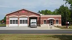
Police services in the borough are provided 24 hours a day, 7 days a week by the Quakertown Borough Police Department, which consists of a Chief, Detective Lieutenant, Administrative Sergeant, two Patrol Sergeants, two Detectives, twelve Patrol Officers, and three support staff.[38] Fire protection in Quakertown and surrounding areas is provided by the Quakertown Fire Department, a volunteer fire department which operates the Quakertown Fire Company #1-Station 17 on West Broad Street and the West End Fire Company-Station 18 on Park Avenue.[39]
Education
Quakertown Community School District serves public school students in the borough.[40] Quakertown Elementary School, a historic school, and Neidig Elementary School, both located within borough limits, serve students in grades K-5 based on where they live. The Sixth Grade Center serves borough students in sixth grade, Strayer Middle School serves grades 7-8, and Quakertown Community High School serves grades 9-12.
The Archdiocese of Philadelphia operates St. Isidore school, located within borough limits, for many parochial school students. The borough is also home to the United Friends School.
Notable people
- Megan Angelo, journalist and author
- Karen Bliss, former American cyclist
- Tom Bossert, an American lawyer and former Homeland Security Advisor to U.S. President Donald Trump
- Diane Bracalente, U.S. 1988 Summer Olympic field hockey player
- Sabrina Carpenter, singer and actress
- Katlyn Chookagian, UFC Fighter
- Reuben Swinburne Clymer, an American occultist and modern Rosicrucian Supreme Grand Master of the FRC (Fraternitas Rosae Crucis)
- Jill Davis (tennis), an American former professional tennis player
- Charles Fechter, an Anglo-French actor
- Oliver W. Frey, a Democratic member of the U.S. House of Representatives from Pennsylvania
- Ray Hartranft, a professional baseball player, Philadelphia Phillies
- John Robert Kline, an American mathematician and educator
- Tim Lewis, former professional football player for the Green Bay Packers
- Will Lewis (American football), an American football executive and former professional player, including the Seattle Seahawks and Kansas City Chiefs
- Bill Mensch, microcomputer pioneer
- George Papashvily, writer and sculptor
- Frances Quinlan, an American singer-songwriter, guitarist and visual artist best known for fronting Philadelphia indie rock band Hop Along
- Rebecca Quinn (cyclist), an American professional racing cyclist
- Louis Riddick, former professional football player for the San Francisco 49ers and Monday Night Football analyst
- Robb Riddick, a former professional football player for the Buffalo Bills
- Jeff Rodenberger, a former professional football player for the Philadelphia/Baltimore Stars and New Orleans Saints
- Priscilla Kepner Sage, an American textile and fiber artist
- Ken Schroy, former professional football player for the New York Jets
- Jan Shepard, film and television actress
- Clyde Smoll, a professional baseball player, Philadelphia Phillies
- Meredith Stern, an artist, musician and disc jockey
- Hampton S. Thomas, Medal of Honor recipient in the American Civil War.[41]
- Neil Vipond, Canadian-American actor
References
- "ArcGIS REST Services Directory". United States Census Bureau. Retrieved October 16, 2022.
- "Census Population API". United States Census Bureau. Retrieved October 12, 2022.
- "Race, Hispanic or Latino, Age, and Housing Occupancy: 2010 Census Redistricting Data (Public Law 94-171) Summary File (QT-PL), Quakertown borough, Pennsylvania". United States Census Bureau. Retrieved August 11, 2011.
- "History". Borough of Quakertown. Retrieved November 2, 2012.
- "National Register Information System". National Register of Historic Places. National Park Service. July 9, 2010.
- Lehigh Valley Transit Company's Liberty Bell Route : A Photographic History with Chronology, Historical Recollections and Bibliography: William J McKelvey Jr
- "USDA Interactive Plant Hardiness Map". United States Department of Agriculture. Retrieved October 16, 2019.
- "PRISM Climate Group, Oregon State University". Retrieved October 16, 2019.
- "U.S. Potential Natural Vegetation, Original Kuchler Types, v2.0 (Spatially Adjusted to Correct Geometric Distortions)". Retrieved October 16, 2019.
- "Census of Population and Housing". U.S. Census Bureau. Retrieved December 11, 2013.
- "U.S. Census website". United States Census Bureau. Retrieved January 31, 2008.
- "Incorporated Places and Minor Civil Divisions Datasets: Subcounty Resident Population Estimates: April 1, 2010 to July 1, 2012". Population Estimates. U.S. Census Bureau. Archived from the original on June 11, 2013. Retrieved December 11, 2013.
- "Census 2020".
- "U.S. Census Bureau QuickFacts: Quakertown borough, Pennsylvania". www.census.gov. Retrieved October 8, 2021.
- "Borough Council". Borough of Quakertown. Retrieved June 29, 2017.
- "Council Members". Borough of Quakertown. Retrieved June 29, 2017.
- "Quakertown Borough map" (PDF). PennDOT. Retrieved March 11, 2023.
- Google (November 21, 2013). "overview of Quakertown, Pennsylvania" (Map). Google Maps. Google. Retrieved November 21, 2013.
- "Doylestown / Flemington / New York Route - Eastbound to New York City" (PDF). Trans-Bridge Lines. Retrieved March 15, 2023.
- "Doylestown / Flemington / New York Route - Westbound from New York City" (PDF). Trans-Bridge Lines. Retrieved March 15, 2023.
- "FAB 20 - Williamsport - Hazleton - Philadelphia". Fullington Tours. Retrieved October 21, 2017.
- "FAB 21 - Philadelphia - Hazleton - Williamsport". Fullington Tours. Retrieved October 21, 2017.
- "Bus Schedules To/From Philadelphia and Casinos". Martz Trailways. Retrieved August 21, 2019.
- Williams, Gerry (1998). Trains, Trolleys & Transit: A Guide to Philadelphia Area Rail Transit. Piscataway, New Jersey: Railpace Company. p. 83. ISBN 978-0-9621541-7-1.
- East Penn Railroad Map (PDF) (Map). DeskMap Systems. 2011. Retrieved December 12, 2011.
- "Quakertown Airport | Bucks County Airport Authority". Archived from the original on October 6, 2008. Retrieved September 7, 2008.
- "Electric Department". Borough of Quakertown. Retrieved June 29, 2017.
- "Water Department". Borough of Quakertown. Retrieved June 29, 2017.
- "Sewer Department". Borough of Quakertown. Retrieved June 29, 2017.
- "Geographic Footprint". UGI. Retrieved October 4, 2017.
- "Gas Tariff" (PDF). UGI Utilities. July 7, 2017. pp. 5–6. Retrieved October 10, 2017.
- "St. Luke's Upper Bucks Campus". St. Luke's University Health Network. Retrieved December 15, 2019.
- "St. Luke's Quakertown Campus - History". St. Luke's University Health Network. Retrieved October 18, 2017.
- "New St. Luke's Hospital open in Quakertown". Allentown, PA: WFMZ-TV. December 15, 2019. Retrieved December 15, 2019.
- "St. Luke's Quakertown Campus - Our Services". St. Luke's University Health Network. Retrieved October 18, 2017.
- "Health Center at Quakertown". Grand View Health. Retrieved October 18, 2017.
- "Health Center at Quakertown". Lehigh Valley Health Network. Retrieved October 18, 2017.
- "Police". Borough of Quakertown. Retrieved June 29, 2017.
- "Quakertown Fire Department". Borough of Quakertown. Retrieved June 29, 2017.
- "Schools, Youth Sports, Community Groups". Borough of Quakertown. Retrieved June 24, 2021.
- "Hampton S. Thomas". Archived from the original on July 14, 2014. Retrieved July 4, 2014.
External links
Places adjacent to Quakertown, Pennsylvania | ||||||||||||||||
|---|---|---|---|---|---|---|---|---|---|---|---|---|---|---|---|---|
| ||||||||||||||||
