Quebec Route 111
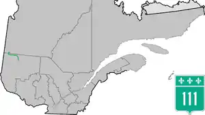
Route 111 is a north/south highway on the north shore of the Saint-Lawrence River in the Abitibi-Témiscamingue region of Quebec, Canada. Its northern terminus is in the municipality of Baie-James at the junction of Route 393, and its southern terminus is in Val-d'Or at the junction of Route 117.
Route 111 | ||||
|---|---|---|---|---|
 | ||||
| Route information | ||||
| Maintained by Transports Québec | ||||
| Length | 204.4 km[1] (127.0 mi) | |||
| Major junctions | ||||
| South end | ||||
| North end | ||||
| Location | ||||
| Country | Canada | |||
| Province | Quebec | |||
| Highway system | ||||
| ||||

Municipalities along Route 111
.jpg.webp)
Quebec Route 111 in Authier
Major intersections
| RCM or ET | Municipality | Km | Junction | Notes |
|---|---|---|---|---|
Southern terminus of Route 111 | ||||
| La Vallée-de-l'Or | Val-d'Or | 0.0 | 117 NORTH: to Rouyn-Noranda 117 SOUTH: to Mont-Laurier | |
| Abitibi | Saint-Marc-de-Figuery | 58.1 | 386 EAST: to Senneterre | |
| Amos | 63.8 | 395 NORTH: to La Morandière-Rochebaucourt | ||
| 65.6 | 109 SOUTH: to Rivière-Héva | |||
| 395 SOUTH: to Preissac | ||||
| 66.9 | 109 NORTH: to Matagami | |||
| Trécesson | 76.6 | 399 NORTH: to Berry | ||
| Launay | 100.5 | Chemin des 6e et 10e rang | NORTH: to Lac-Chicobi | |
| Abitibi-Ouest | Taschereau | 112.5 | 390 WEST: to Poularies | |
| Authier | 132.9 | Chemin Principale | NORTH: to Authier-Nord | |
| Macamic | 143.4 | 101 SOUTH: to Rouyn-Noranda | ||
| La Sarre | 159.2 | 393 SOUTH: to Sainte-Hélène-de-Mancebourg | ||
| 161.1 | 393 NORTH: to Clermont | |||
| Dupuy | 179.4 | Chemin-du-1e-et-10e-rang | WEST: to La Reine | |
| Jamésie | Baie-James (Beaucanton) |
204.4 | WEST: to | |
Northern terminus of Route 111 | ||||
See also
References
- Ministère des transports, "Distances routières", page 57, Les Publications du Québec, 2005
External links
- Official Transport Quebec Road Map (Courtesy of the Quebec Ministry of Transportation) (in French)
- Route 111 on Google Maps
This article is issued from Wikipedia. The text is licensed under Creative Commons - Attribution - Sharealike. Additional terms may apply for the media files.