Phillipston, Massachusetts
Phillipston is a town in Worcester County, Massachusetts, United States. The population was 1,724 at the 2020 census.[1]
Phillipston, Massachusetts | |
|---|---|
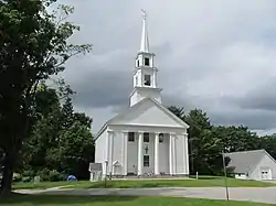
 Congregational Church | |
 Seal | |
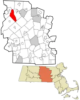
 Location in Worcester County and the state of Massachusetts. | |
| Coordinates: 42°32′55″N 72°08′00″W | |
| Country | United States |
| State | Massachusetts |
| County | Worcester |
| Settled | 1751 |
| Incorporated | 1786 |
| Government | |
| • Type | Open town meeting |
| • Administrative Assistant | Susan Varney |
| Area | |
| • Total | 24.6 sq mi (63.8 km2) |
| • Land | 24.3 sq mi (62.8 km2) |
| • Water | 0.4 sq mi (1.0 km2) |
| Elevation | 1,166 ft (355 m) |
| Population (2020) | |
| • Total | 1,724 |
| • Density | 70/sq mi (27/km2) |
| Time zone | UTC-5 (Eastern) |
| • Summer (DST) | UTC-4 (Eastern) |
| ZIP code | 01331 |
| Area code | 351 / 978 |
| FIPS code | 25-53225 |
| GNIS feature ID | 0619487 |
| Website | http://www.phillipston-ma.gov |
History
Phillipston was first settled in 1751, and incorporated as the town of Gerry, after the politician Elbridge Gerry, on October 20, 1786, after separating from Templeton.[2] The name was changed to Phillipston on February 5, 1814, after William Phillips, Jr., the tenth Lieutenant Governor of Massachusetts[3]
In 1941, Elliott Laurel was gifted to The Trustees of Reservations.
The Phillipston Center Historic District and the Searles Hill Cemetery were designated on the National Register of Historic Places, in 1999 and 2011 respectively.
Geography
According to the United States Census Bureau, the town has a total area of 24.6 square miles (64 km2), of which 24.3 square miles (63 km2) is land and 0.4 square miles (1.0 km2), or 1.54%, is water.
Phillipston is bordered by Petersham to the southwest, Athol to the northwest, Royalston to the north, Templeton to the east, Hubbardston to the southeast, and a small portion of Barre to the south.
Demographics
| Year | Pop. | ±% |
|---|---|---|
| 1850 | 809 | — |
| 1860 | 764 | −5.6% |
| 1870 | 693 | −9.3% |
| 1880 | 621 | −10.4% |
| 1890 | 502 | −19.2% |
| 1900 | 441 | −12.2% |
| 1910 | 426 | −3.4% |
| 1920 | 354 | −16.9% |
| 1930 | 357 | +0.8% |
| 1940 | 481 | +34.7% |
| 1950 | 638 | +32.6% |
| 1960 | 695 | +8.9% |
| 1970 | 872 | +25.5% |
| 1980 | 953 | +9.3% |
| 1990 | 1,485 | +55.8% |
| 2000 | 1,621 | +9.2% |
| 2010 | 1,682 | +3.8% |
| 2020 | 1,724 | +2.5% |
| * = population estimate. Source: United States census records and Population Estimates Program data.[4][5][6][7][8][9][10][11][12][13] | ||
As of the census[14] of 2000, there were 1,621 people, 580 households, and 443 families residing in the town. The population density was 66.8 inhabitants per square mile (25.8/km2). There were 739 housing units at an average density of 30.5 per square mile (11.8/km2). The racial makeup of the town was 97.72% White, 0.37% African American, 0.12% Native American, 0.37% Asian, and 1.42% from two or more races. Hispanic or Latino of any race were 0.43% of the population.
There were 580 households, of which 39.5% had children under the age of 18 living with them, 63.8% were married couples living together, 8.1% had a female householder with no husband present, and 23.6% were non-families. 17.6% of all households were made up of individuals, and 5.0% had someone living alone who was 65 years of age or older. The average household size was 2.79 and the average family size was 3.19.
In the town, the population was spread out, with 29.2% under the age of 18, 5.2% from 18 to 24, 33.3% from 25 to 44, 24.7% from 45 to 64, and 7.5% who were 65 years of age or older. The median age was 37 years. For every 100 females, there were 101.1 males. For every 100 females age 18 and over, there were 106.7 males.
The median income for a household in the town was $46,845, and the median income for a family was $52,011. Males had a median income of $39,231 versus $25,625 for females. The per capita income for the town was $18,706. About 3.8% of families and 5.8% of the population were below the poverty line, including 8.5% of those under age 18 and 4.0% of those age 65 or over.
Government
| County-level state agency heads | |
|---|---|
| Clerk of Courts: | Dennis P. McManus (D) |
| District Attorney: | Joe Early Jr. (D) |
| Register of Deeds: | Katie Toomey (D) |
| Register of Probate: | Stephanie Fattman (R) |
| County Sheriff: | Lew Evangelidis (R) |
| State government | |
| State Representative(s): | Susannah Whipps Lee (R) |
| State Senator(s): | Anne Gobi (D) |
| Governor's Councilor(s): | Jen Caissie (R) |
| Federal government | |
| U.S. Representative(s): | James P. McGovern (D-2nd District), |
| U.S. Senators: | Elizabeth Warren (D), Ed Markey (D) |
Education
Phillipston is part of the Narragansett Regional School District, along with Templeton. Previously, the town served one public elementary school, the Phillipston Memorial School, but was closed recently, so elementary school students attend Templeton Memorial School in Templeton. Middle School students attend Narragansett Regional Middle School, and high school students attend Narragansett Regional High School. In 1948, the architect G. Adolph Johnson designed the Phillipston Memorial School. Additionally, Mount Wachusett Community College serves the area.
Library
"The Phillips Free Public Library of Phillipston was founded in 1860."[15][16] In fiscal year 2008, the town of Phillipston spent 1.08% ($31,203) of its budget on its public library—approximately $17 per person, per year ($20.82 adjusted for inflation to 2021).[17]
Notable people
- Charlotte Barnum, mathematician
- Thomas H. White, industrialist
References
- "Census - Geography Profile: Phillipston town, Worcester County, Massachusetts". United States Census Bureau. Retrieved November 12, 2021.
- "MHC Reconnaissance Survey Town Report: Phillipston" (PDF). Massachusetts Historical Commission. 1984. Retrieved January 8, 2015.
- "Profile for Phillipston, Massachusetts". ePodunk. Archived from the original on June 9, 2011. Retrieved May 7, 2010.
- "Total Population (P1), 2010 Census Summary File 1". American FactFinder, All County Subdivisions within Massachusetts. United States Census Bureau. 2010.
- "Massachusetts by Place and County Subdivision - GCT-T1. Population Estimates". United States Census Bureau. Retrieved July 12, 2011.
- "1990 Census of Population, General Population Characteristics: Massachusetts" (PDF). US Census Bureau. December 1990. Table 76: General Characteristics of Persons, Households, and Families: 1990. 1990 CP-1-23. Retrieved July 12, 2011.
- "1980 Census of the Population, Number of Inhabitants: Massachusetts" (PDF). US Census Bureau. December 1981. Table 4. Populations of County Subdivisions: 1960 to 1980. PC80-1-A23. Retrieved July 12, 2011.
- "1950 Census of Population" (PDF). Bureau of the Census. 1952. Section 6, Pages 21-10 and 21-11, Massachusetts Table 6. Population of Counties by Minor Civil Divisions: 1930 to 1950. Retrieved July 12, 2011.
- "1920 Census of Population" (PDF). Bureau of the Census. Number of Inhabitants, by Counties and Minor Civil Divisions. Pages 21-5 through 21-7. Massachusetts Table 2. Population of Counties by Minor Civil Divisions: 1920, 1910, and 1920. Retrieved July 12, 2011.
- "1890 Census of the Population" (PDF). Department of the Interior, Census Office. Pages 179 through 182. Massachusetts Table 5. Population of States and Territories by Minor Civil Divisions: 1880 and 1890. Retrieved July 12, 2011.
- "1870 Census of the Population" (PDF). Department of the Interior, Census Office. 1872. Pages 217 through 220. Table IX. Population of Minor Civil Divisions, &c. Massachusetts. Retrieved July 12, 2011.
- "1860 Census" (PDF). Department of the Interior, Census Office. 1864. Pages 220 through 226. State of Massachusetts Table No. 3. Populations of Cities, Towns, &c. Retrieved July 12, 2011.
- "1850 Census" (PDF). Department of the Interior, Census Office. 1854. Pages 338 through 393. Populations of Cities, Towns, &c. Retrieved July 12, 2011.
- "U.S. Census website". United States Census Bureau. Retrieved January 31, 2008.
- Massachusetts Board of Library Commissioners (1891). Report of the Free Public Library Commission of Massachusetts. Boston: Wright & Potter. pp. 187–188.
- http://phillipstonlibrary.org%7C accessdate=2015-01-07
- "The FY2008 Municipal Pie: What's Your Share?". Boston: Commonwealth of Massachusetts, Board of Library Commissioners. December 2009: 3. Archived from the original on January 23, 2012. Retrieved January 8, 2015.
Fiscal year: July 1, 2007 through June 30, 2008
{{cite journal}}: Cite journal requires|journal=(help)
