Radvanice (Přerov District)
Radvanice is a municipality and village in Přerov District in the Olomouc Region of the Czech Republic. It has about 300 inhabitants.
Radvanice | |
|---|---|
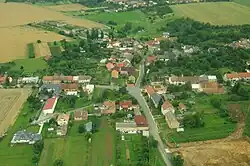 Aerial view | |
 Flag 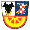 Coat of arms | |
 Radvanice Location in the Czech Republic | |
| Coordinates: 49°30′35″N 17°28′38″E | |
| Country | |
| Region | Olomouc |
| District | Přerov |
| First mentioned | 1374 |
| Area | |
| • Total | 2.92 km2 (1.13 sq mi) |
| Elevation | 268 m (879 ft) |
| Population (2023-01-01)[1] | |
| • Total | 274 |
| • Density | 94/km2 (240/sq mi) |
| Time zone | UTC+1 (CET) |
| • Summer (DST) | UTC+2 (CEST) |
| Postal code | 751 21 |
| Website | www |
Radvanice lies approximately 8 kilometres (5 mi) north of Přerov, 20 km (12 mi) south-east of Olomouc, and 230 km (140 mi) east of Prague.
This article is issued from Wikipedia. The text is licensed under Creative Commons - Attribution - Sharealike. Additional terms may apply for the media files.