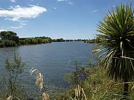
Rangitaiki River
The Rangitaiki River is the longest river in the Bay of Plenty region in New Zealand's North Island. It is 155 kilometres (96 mi) long, and rises inland from northern Hawkes Bay to the east of the Kaingaroa Forest. The Rangitaiki catchment covers an area of 3005 km2.[2] It flows in a generally northeastward direction, passing through the town of Murupara and skirting close to the western edge of Te Urewera National Park before turning northwards, flowing past Edgecumbe and into the Bay of Plenty close to Thornton.
| Rangitaiki River | |
|---|---|
 Rangitaiki River | |
 The Rangitaiki River system | |
| Native name | Rangitaiki (Māori) |
| Location | |
| Country | New Zealand |
| Region | Bay of Plenty |
| District | Taupo, Whakatāne |
| Towns | Murupara, Edgecumbe |
| Physical characteristics | |
| Source | |
| • coordinates | 39°0′7″S 176°26′53″E |
| Mouth | |
• location | Bay of Plenty |
• coordinates | 37°54′32″S 176°52′55″E |
• elevation | Sea level |
| Length | 155 kilometres (96 mi) |
| Basin size | 3,005 square kilometres (1,160 sq mi) |
| Discharge | |
| • average | 74 m3/s (2,600 cu ft/s)[1] |
| Basin features | |
| Tributaries | |
| • right | Otamatea River, Wheao River, Whirinaki River, Horomanga River |
| Waterbodies | Lake Āniwaniwa, Lake Matahina |
| Waterfalls | Āniwaniwa Falls |
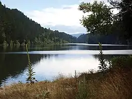
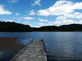
There are two man-made lakes on the Rangitaiki formed by hydro-electric dams, Lake Āniwaniwa (formerly Lake Aniwhenua).[3] and Lake Matahina.
History
In April 2017, remnants of Cyclone Debbie caused heavy rainfall in the region. At 8:30 am on April 6, water from the Rangitaiki River breached the College Road floodwall at Edgecumbe, causing widespread flooding across the township.[4] A state of emergency was declared for the Whakatane District, and around 2,000 people were evacuated to Kawerau and Whakatane.[4][5] More than 300 homes were damaged, with some becoming uninhabitable.[6] A review of the flood was undertaken by a panel consisting of Sir Michael Cullen (chair), Kyle Christensen, and Charlie Price.[7]
Course
The river is 155 kilometres (96 mi) long, rising at an elevation of 740 metres (2,430 ft) [7] above mean sea level, 32 kilometres (20 mi) east of Lake Taupo and 130 kilometres (81 mi) south of the Bay of Plenty coast. From its source in the Ahimanawa Ranges[2] it flows for 64 kilometres (40 mi) across the Kaingaroa Plains towards Murupara.[8] Near the northern edge of the plains the river has been dammed by the Rangitāiki Dam, approximately 18 kilometres (11 mi) downstream of its confluence with the Wheao River. The dam diverts all but at least 0.5 cumecs into the Wheao and Flaxy power scheme, which discharges into Wheao River which joins the Rangitaiki upstream of Murupara.
By the time it reaches the settlement at Murupara the river has a catchment of over 720 km2.[8]
Within 20 kilometres (12 mi) downstream of Murupara, two major tributaries, the Whirinaki River and the Horomanga River enter the river on the eastern side. The river then continues north over the Galatea Plains before it enters the man-made Lake Āniwaniwa, the waters of which power the Aniwhenua Power Station.
Below the power station the river passes over the Aniwhenua falls and then squeezes through a narrow chasm. Downstream of the dam, the main channel passes through a gorge and then out onto the Waiohau Plains and past the settlement of Waihau. Several small tributaries arising in the Ikawhenua Ranges cross the Waiohau Plains to join the Rangitaiki.
The river travels for 13 kilometres (8.1 mi) across the Waiohau Plains before it enters a gorge housing the man-made Lake Matahina the waters of which power the Matahina Power Station. No major tributaries enter the river downstream of the Lake Matahina. Below Matahina the Rangitaiki passes the village of Te Mahoe and through a well-defined valley before crossing the 29,000 ha Rangitaiki Plains and passing the settlements of Te Teko, Edgecumbe and Thornton. At Edgecumbe a large dairy factory owned by Fonterra discharges waste products into the river.
The river finally enters the sea at Thornton through a man made 1,500 metres (4,900 ft) long channel.[8]
Watershed
Prior to the completion of the Matahina Dam annual discharge figures for suspended and bed load sediment near the river mouth were about 201,000 and 188,000 tonne respectively, Since then the Matahina dam has acted as an effective barrier to the seaward movement of sediment by the Rangitaiki River, with equivalent post-dam values have dropped to 65,000 and 10,000 tonne.[9] This trapping of sediment has halted or substantially reduced the downstream historical rising river bed and coastal progradation of the Rangitaiki plains. [10]
Since the completion of the upstream Aniwhenua dam in 1982, it had become the principal sediment capture point though an increasing amount of sediment is being deposited in the deep portion of Lake Matahina. The river's condition is monitored at Murupara, Aniwhenua and Te Teko.[2]
River modifications
The arrival of Europeans in the area lead to draining of wetland and low-lying areas along the river to create usable agricultural and horticultural lands. To support these activities the Rangitaiki Land Drainage Act was passed in 1910. One the Rangitaiki plains approximately 40,000 hectares of wetland was drained and converted to farmland.[7] At the same time the existing dual discharges of the river towards the Whakatane River to the east and the Tarawera River estuary to the west were replaced by the cutting of a channel near Thornton to provide a new direct outlet for the Rangitaiki to the sea.[8] Within a day of the new outlet being opened in May 1914 the level of the Rangitaiki in the lower sections of the Rangitaiki Plains area dropped by approximately1.5 metres (4.9 ft). This fall of the river level encouraged further agricultural and horticultural development in this area following the end of World War I.
The hydro-electric potential of the river has been utilized by the construction of the following generation stations:
- Matahina Power Station: Commissioned in 1967 the associated 86 m high Matahina Dam has impounds the river to create Lake Matahina. Due to the lake's limited storage capacity the power station operates as a run of the river scheme. The power station can generate up to 80 MW.
- Aniwhenua Power Station: Commissioned in 1981, above the Āniwaniwa Falls its associated 10 high dam impounds the Rangitaiki River and Pokairoa Stream at their confluence at Black Road, Galatea, approximately 65 kilometres (40 mi) upstream from the river mouth to create Lake Āniwaniwa (unofficially known as Lake Aniwhenua). The lake supports a regionally significant trout fishery, as well as duck shooting and other recreation activities. Due to the lake's limited storage capacity the power station operates as a run of the river scheme. The power station can generate up to 25 MW.
- Wheao and Flaxy Power Scheme: Located in the Kaingaroa forest this scheme was commissioned in 1980 and diverts water from the Flaxy Creek, Rangitaiki and Wheao rivers to power the 24 MW Wheao and the 2.1 MW Flaxy Power Stations. Due to the scheme's limited storage capacity it operates as a run of the river scheme.
Stopbanks
The development of flood control, mitigation schemes and drainage schemes was undertaken u to the requirements of the Land Drainage Act 1908, Soil Conservation and Rivers Control Act 1941, and specificity for the Rangitaiki catchment Rangitaiki Land Drainage Act 1910 and the Rangitāiki Land Drainage Act 1956.[7] To assist in controlling floods settlements and productive land downstream of Te Teko is protected by a system of stopbanks (also known as floodbanks). These are designed to provide protection from a 1% Annual Exceedance Probability (AEP) flood (also known as the “100 year” flood).[8]
Tributaries
Heading downstream from its source the river has the following tributaries:
- Otamatea River.
- Otangimoana Stream. Also known as Dry Fly Creek
- Wheao River. This joins the Rangitaiki upstream of Murupara.
- Horomanga River. This river which joins the Rangitaiki 12 kilometres (7.5 mi) north of Murupara has a catchment of 218 km2. Like the Whirinaki this rises in the Ikawhenua Ranges and also contributes relatively large flood flows (and quantities of shingle) to the Rangitaiki.
- Haumea Stream.
- Whirinaki River. This rivers which joins the Rangitaiki 3 kilometres (1.9 mi) north of Murupara has a catchment of 527 km2. This river rises in the steep bush–covered Ikawhenua Ranges. Being composed of greywacke rock, with little absorption ability there is a resulting high runoff and so it consequently contributes relatively large flood flows (and quantities of shingle) to the Rangitaiki.
- Mangamako Stream,
- Waihua Stream
- Waikakopu Stream.
- Pokairoa Stream.
Gallery
 Lake Matahina
 River fishing at Thornton
 Lake Āniwaniwa
 Recreational jet boating on the Rangitaiki River, 1971
References
- "NIWA Water & soil miscellaneous publication no. 48 (1983)" (PDF). Archived (PDF) from the original on 13 April 2021. Retrieved 13 April 2021.
- "Rangitāiki". Land, Air, Water Aotearoa (LAWA). Retrieved 12 October 2021.
- Deed of Settlement between the Crown and Te Rūnanga o Ngāti Manawa (PDF) (Report). New Zealand Government. 2009. Retrieved 13 May 2020.
Lake Aniwhenua will be changed to Lake Āniwaniwa and Aniwhenua Falls will be changed to Āniwaniwa Falls.
- "Edgecumbe evacuates as water swamps the town - National - NZ Herald News". NZ Herald. 6 April 2017. Retrieved 8 April 2017.
- "State of emergency declared". SunLive. 6 April 2017. Retrieved 5 July 2018.
- "Edgecumbe flood anniversary: A year of highs and lows". Nzherald.co.nz. 31 March 2018. Retrieved 5 July 2018.
- Rangitāiki River Scheme Review – April 2017 Flood Event (PDF) (Report). Rangitāiki River Scheme Review Panel. 18 September 2017. pp. 11, 14, 15, 24.
- Wallace, Philip (1998). Rangitaiki - Tarawera Rivers Scheme Asset Management Plan (PDF) (Report). Whakatane: Environment Bay of Plenty. p. 9.
- Phillips, Christopher John; Nelson, Campbell S. (December 1981). "Sedimentation in an Artificial Lake - Lake Matahina, Bay of Plenty". New Zealand Journal of Marine and Freshwater Research. Wellington: Royal Society Te Apārangi. 15 (4): 459–473.
- Millais, Peter (13 May 2009). Matahina Hydroelectric Power Scheme Reconsenting Project: River Hydrology, Hydraulics and Bank Erosion (PDF) (Report). Beca Infrastructure Ltd. p. 16. Retrieved 20 September 2021.
Further reading
- Boubée, Jacques; Hudson, Neale (May 2009). Assessment of the State of the Rangitaiki River within the Ngati Manawa Rohe (PDF) (Report). Hamilton: National Institute & Atmospheric Research Ltd.
- Titchrnarsh, Ross (1996). Rangitaiki Tarawera River Scheme Maintenance Review (PDF) (Report). Whakatane: Environment Bay of Plenty.
- Wilding, Thomas K. (2004). Minimum Flows for the Whirinaki River and Upper- Rangitaiki River (PDF) (Report). Hamilton: National Institute & Atmospheric Research Ltd.
External links
- Hydro-Electric Schemes Compliance Report June 2010 – June 2013.
- Te Ika Whenua Rivers Report. This report issued by the Waitangi Tribunal in 1998 discusses the claims of the Te Ika Whenua hapu over the Rangitaiki, Wheao, and Whirinaki Rivers and their tributaries.
- Rangitaiki River. Describes the fishing options on the river.
- Rangitaiki River System, Horomanga and Whirinaki. Brochure produced by Fish and Game describing fishing options and access points on the river.