Raumati South
Raumati South is a coastal community on the Kāpiti Coast of New Zealand's North Island. It is 50km north-west of Wellington, and immediately south of Raumati Beach and south-west of Paraparaumu. The Maungakotukutuku area is located inland.[3]
Raumati South | |
|---|---|
Town | |
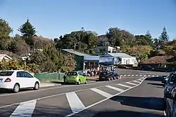 Raumati South village | |
| Coordinates: 40.936271°S 174.977409°E | |
| Country | New Zealand |
| Region | Wellington Region |
| Territorial authority | Kāpiti Coast District |
| Ward | Paekākāriki-Raumati Ward |
| Community | Raumati Community |
| Electorates | |
| Government | |
| • Territorial Authority | Kāpiti Coast District Council |
| • Regional council | Greater Wellington Regional Council |
| • Kāpiti Coast Mayor | Janet Holborow |
| • Mana MP | Barbara Edmonds |
| • Te Tai Hauāuru MP | Debbie Ngarewa-Packer |
| Area | |
| • Total | 5.65 km2 (2.18 sq mi) |
| Population (June 2023)[2] | |
| • Total | 4,080 |
| • Density | 720/km2 (1,900/sq mi) |
| Postcode(s) | 5032 |
| Area code | 04 |
"Raumati" is the Māori language word for "summer".
In 1912, Herbert and William Eatwell had named the place Kawatiri, but the name was changed to the current one in 1934 because of another place with the same name in the Tasman Region.[4]
To the south of the town, between it and the town of Paekākāriki, is the Queen Elizabeth Park, a 638 hectare regional park used during the filming of The Lord of the Rings: The Return of the King, where it represented Pelennor Fields. Raumati South is known for the large number of its residents pursuing alternative lifestyles and artistic endeavors. The main primary education provider is Raumati South Primary School. There is also a Steiner school called 'Te Ra' located on Poplar Avenue.
Demographics
Raumati South statistical area covers 5.65 km2 (2.18 sq mi).[1] It had an estimated population of 4,080 as of June 2023, with a population density of 722.12 people per km2.
| Year | Pop. | ±% p.a. |
|---|---|---|
| 2006 | 3,546 | — |
| 2013 | 3,594 | +0.19% |
| 2018 | 3,753 | +0.87% |
| Source: [5] | ||
Raumati South had a population of 3,753 at the 2018 New Zealand census, an increase of 159 people (4.4%) since the 2013 census, and an increase of 207 people (5.8%) since the 2006 census. There were 1,416 households, comprising 1,827 males and 1,923 females, giving a sex ratio of 0.95 males per female. The median age was 42.8 years (compared with 37.4 years nationally), with 828 people (22.1%) aged under 15 years, 504 (13.4%) aged 15 to 29, 1,914 (51.0%) aged 30 to 64, and 504 (13.4%) aged 65 or older.
Ethnicities were 91.4% European/Pākehā, 11.7% Māori, 3.7% Pasifika, 3.4% Asian, and 2.3% other ethnicities. People may identify with more than one ethnicity.
The percentage of people born overseas was 24.3, compared with 27.1% nationally.
Although some people chose not to answer the census's question about religious affiliation, 61.5% had no religion, 26.2% were Christian, 0.2% had Māori religious beliefs, 0.6% were Hindu, 0.2% were Muslim, 0.7% were Buddhist and 2.6% had other religions.
Of those at least 15 years old, 903 (30.9%) people had a bachelor's or higher degree, and 297 (10.2%) people had no formal qualifications. The median income was $36,900, compared with $31,800 nationally. 723 people (24.7%) earned over $70,000 compared to 17.2% nationally. The employment status of those at least 15 was that 1,482 (50.7%) people were employed full-time, 474 (16.2%) were part-time, and 108 (3.7%) were unemployed.[5]
Sports and parks
Tennis courts were built by Bert Eatwell in Raumati South (then Kawatiri) in about 1930. The first tennis club in Raumati South was established in the mid-1940s. A bowling club was established in Raumati South in 1945 but is no longer operating. A surf club was established in Raumati South in 1955.[4]
Education
Raumati South School is a co-educational state primary school for Year 1 to 8 students,[6][7] with a roll of 362 as of April 2023.[8]
Te Ra School is a co-educational state-integrated primary school for Year 1 to 8 students,[9][10] with a roll of 146.[11]
References
- "ArcGIS Web Application". statsnz.maps.arcgis.com. Retrieved 21 May 2021.
- "Population estimate tables - NZ.Stat". Statistics New Zealand. Retrieved 25 October 2023.
- Raumati South, heart and soul : our community's story of our history by Jacqueline Elliot, published by Otaki, 2008, ISBN 978-0-473-13741-0
- Perry, Maurice (2008). "Raumati South – Kawatiri – Some Early Memories" (pdf). Maurice Perry and Raumati South. Retrieved 1 November 2010.
- "Statistical area 1 dataset for 2018 Census". Statistics New Zealand. March 2020. Raumati South (238500). 2018 Census place summary: Raumati South
- "Raumati South School Official School Website". raumatisouth.school.nz.
- "Raumati South School Ministry of Education School Profile". educationcounts.govt.nz. Ministry of Education.
- "Raumati South School Education Review Office Report". ero.govt.nz. Education Review Office.
- "Te Ra School Official School Website". tera.school.nz.
- "Te Ra School Ministry of Education School Profile". educationcounts.govt.nz. Ministry of Education.
- "Te Ra School Education Review Office Report". ero.govt.nz. Education Review Office.