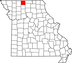
Ravanna, Missouri
Ravanna is a census-designated place in Mercer County, Missouri, United States.[3] It is located approximately seven miles northeast of Princeton on U.S. Route 136. The population was 60 at the 2020 census.[4]
Ravanna, Missouri | |
|---|---|
 Ravanna, Missouri Location within Missouri | |
| Coordinates: 40°27′22″N 93°27′43″W | |
| Country | United States |
| State | Missouri |
| County | Mercer County |
| Area | |
| • Total | 3.97 sq mi (10.28 km2) |
| • Land | 3.96 sq mi (10.24 km2) |
| • Water | 0.01 sq mi (0.03 km2) |
| Elevation | 1,073 ft (327 m) |
| Population (2020) | |
| • Total | 60 |
| • Density | 15.17/sq mi (5.86/km2) |
| FIPS code | 29-60644 |
| GNIS feature ID | 2587109[2] |
Ravanna was platted in 1857.[5] A variant name was "Sonoma".[6] A post office called Sonoma was established in 1855, the name was changed to Ravanna in 1858, and the post office closed in 1975.[7] The present name most likely is a transfer from Ravenna, Ohio.[8]
Education
The northern half is in the North Mercer School District, including the main townsite, while other parts are in the Princeton R-5 School District.[9] The community was previously part of the Ravanna R-IV School District until the school closed in 1977 due to financial problems. Ravanna's mascot was the Ranger.
References
- "ArcGIS REST Services Directory". United States Census Bureau. Retrieved September 5, 2022.
- U.S. Geological Survey Geographic Names Information System: Ravanna, Missouri
- U.S. Geological Survey Geographic Names Information System: Ravanna Census Designated Place
- "Explore Census Data". data.census.gov. Retrieved December 16, 2021.
- Ramsay, Robert L. (1952). Our Storehouse of Missouri Place Names. University of Missouri Press. p. 25. ISBN 9780826205865.
- U.S. Geological Survey Geographic Names Information System: 735816
- "Post Offices". Jim Forte Postal History. Retrieved November 5, 2016.
- "Mercer County Place Names, 1928–1945". The State Historical Society of Missouri. Archived from the original on June 24, 2016. Retrieved November 5, 2016.
- "2020 CENSUS - SCHOOL DISTRICT REFERENCE MAP: Mercer County, MO" (PDF). U.S. Census Bureau. Retrieved February 24, 2022.
- "Census of Population and Housing". Census.gov. Retrieved June 4, 2016.
