Ravensbourne, Queensland
Ravensbourne is a rural locality in the Toowoomba Region, Queensland, Australia.[2] In the 2016 census, Ravensbourne had a population of 248 people.[1]
| Ravensbourne Queensland | |||||||||||||||
|---|---|---|---|---|---|---|---|---|---|---|---|---|---|---|---|
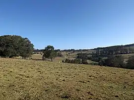
 The rolling hills of Ravensbourne, 2014 | |||||||||||||||
 Ravensbourne | |||||||||||||||
| Coordinates | 27.3358°S 152.1586°E | ||||||||||||||
| Population | 248 (2016 census)[1] | ||||||||||||||
| • Density | 3.028/km2 (7.843/sq mi) | ||||||||||||||
| Postcode(s) | 4352 | ||||||||||||||
| Area | 81.9 km2 (31.6 sq mi) | ||||||||||||||
| Time zone | AEST (UTC+10:00) | ||||||||||||||
| LGA(s) | Toowoomba Region | ||||||||||||||
| State electorate(s) | Condamine | ||||||||||||||
| Federal division(s) | Maranoa | ||||||||||||||
| |||||||||||||||
Geography
The locality is on the Darling Downs in southern Queensland.[3]
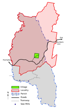
The locality is crossed from east to west by the Esk–Hampton Road.[3]
In the far north is reservoir created behind the Cressbrook Dam. Most of the area is within the catchment of the dammed Cressbrook Creek, a tributary of the Brisbane River. However a small section in the southeast lies within the Lockyer Creek catchment. In this part lies the Ravensbourne National Park. In the west Perseverance Creek marks the boundary.[3]
History
The locality takes its name from the parish, which in turn was named after the pastoral run belonging to a Mr Raven which was near a creek (called a bourne in many parts of England).[2]
A reserve for camping was established in 1880 and cancelled in 1885.[6][7]
A Village Settlement was established in the late 1880s including a post office and a half acre allotment for houses.[8][9]
Ravensbourne Provisional School opened on 22 June 1891. On 1 January 1909, it became Ravensbourne State School. It closed on 31 December 1969.[10] It was at the end of Ravensourne School Road off Post Office Road (27.3595°S 152.1609°E).[11][3]
The school acted as a community meeting hall including for the Farmers' Association.[12] Other additions included a general store and saw mill. The school, post office and general store are no longer in operation.[9]
Few buildings remain in the original village. The site of the school is currently owned by the University of Southern Queensland and is marked as a scientific reserve.[13] In 2003 Reushle Cottage was moved from Post Office Road (in Ravensbourne) to Hampton to act as the visitor information centre.[14]
In the 2016 census, Ravensbourne had a population of 248 people.[1]
Agriculture & Lumber
Evidence of an Aboriginal yam dig site can be found in Ravensbourne national park.[15]
Logging began in the 1860s and 1870s.[15] By 1891 two mills serviced the area, one situated along Perseverance creek and another established circa 1891 closer to the Ravensbourne village settlement.[9]
In 1889 when the Ravensbourne region was opened for selection, large areas were cleared for farming of maize, potatoes and dairy cows.[15]
The rich soil has been used for a range of farming activities including vegetable and flower farming. Present day farming activities include cattle, avocados, limes and a range of other vegetables and meat products.[16]
Mining
Gold prospecting was conducted at Bunkers Hill (located in the Ravensbourne region) in the 1870s and by 1932 the site had grown to 25 men.[17] In 1933 deposits of gold, silver, copper and lead were discovered 22 feet (approximately 7 meters) underground. As with much of the gold mining in the Esk and Brisbane Valley regions, gold mining has remained a sideline compared to farming and grazing activities.[18]
Transport
Early goods were transported by cart from the farms in Ravensbourne to Hampton and then by train from Hampton to Toowoomba for sale. In the 1920s trucks replaced carts for haulage to Hampton or directly to Toowoomba.[20] Sometime after 1932 the Esk–Hampton Road became trafficable allowing access to the Brisbane Valley railway line.
Between 1907 and 1909 the Munro Tramway construction reached Ravensbourne, terminating at Bunkers Hill. The private tramway operated until 1936 haling timber and other freight between the loading stations, saw mills and rail connection at Hampton. Very little evidence remains of the tramway as most of the tramway steel was salvaged shortly after it ceased operation.A partially restored Shay locomotive recovered from Bunkers Hill is on display near the Ravensbourne National Park. [21]
Attractions
There are several short walks along the Munro Tramway and a partially restored Shay locomotive is visible from Esk–Hampton Road near Ravensbourne National park.
Picnic areas and several short walks can be found at Ravensbourne National Park and the Gus Beutel Lookout.
Camping, kangaroos and water activities can be found at Cressbrook Dam and Perseverance Dam.
References
- Australian Bureau of Statistics (27 June 2017). "Ravensbourne (SSC)". 2016 Census QuickStats. Retrieved 20 October 2018.
- "Ravensbourne – locality in Toowoomba Region (entry 48050)". Queensland Place Names. Queensland Government. Retrieved 14 December 2020.
- "Queensland Globe". State of Queensland. Retrieved 5 April 2022.
- "Queensland Globe". Queensland Government. Archived from the original on 19 December 2017. Retrieved 27 December 2020.
- Munro Tramway Historical Group Inc. "Trail Signs". Archived from the original on 5 April 2022. Retrieved 29 December 2020.
- "OFFICIAL NOTIFICATIONS". The Brisbane Courier. Vol. XL, no. 8, 616. Queensland, Australia. 22 August 1885. p. 3. Archived from the original on 5 April 2022. Retrieved 27 December 2020 – via National Library of Australia.
- "OFFICIAL NOTIFICATIONS". The Week. Vol. IX, no. 218. Queensland, Australia. 28 February 1880. p. 8. Archived from the original on 5 April 2022. Retrieved 27 December 2020 – via National Library of Australia.
- "Crows Nest Queensland -- Ravensbourne". Archived from the original on 5 April 2022. Retrieved 27 December 2020.
- "RAVENSBOURNE VILLAGE SETTLEMENT". The Brisbane Courier. Vol. XLVII, no. 10, 304. Queensland, Australia. 23 January 1891. p. 4. Archived from the original on 5 April 2022. Retrieved 27 December 2020 – via National Library of Australia.
- Queensland Family History Society (2010), Queensland schools past and present (Version 1.01 ed.), Queensland Family History Society, ISBN 978-1-921171-26-0
- "Queensland Two Mile series sheet 2m43" (Map). Queensland Government. 1937. Archived from the original on 5 April 2022. Retrieved 5 April 2022.
- "Ravensbourne". Darling Downs Gazette. Vol. XXXVI, no. 8, 019. Queensland, Australia. 28 March 1894. p. 3. Archived from the original on 5 April 2022. Retrieved 27 December 2020 – via National Library of Australia.
- Google (27 December 2020). "Ravensbourne, Queensland" (Map). Google Maps. Google. Retrieved 27 December 2020.
- "Reushle Cottage". Retrieved 30 December 2020.
- "Ravensbourne National Park -- Nature, culture and history". Department of Environment and Science -- Parks and Forests. Queensland Government. Archived from the original on 25 January 2021. Retrieved 27 December 2020.
- "Ravensbourne Escape -- News". Archived from the original on 28 November 2020. Retrieved 27 December 2020.
- "Gold Discovery at Bunkers Hill". 27 December 1932. Archived from the original on 5 April 2022. Retrieved 27 December 2020.
- Ruth Kerr (1988). Confidence and Tradittion. ISBN 0731615689. Archived from the original on 5 April 2022. Retrieved 27 December 2020.
- Queensland Resources Council and the Department of Natural Resources and Mines (2005). Exploring Mining in Queensland: Past, Present and Future (PDF). ISBN 0957870124.
- Crows Nest Information. "Friedrich Reushle". Archived from the original on 5 April 2022. Retrieved 29 December 2020.
- Munro Tramway Historical Group Inc. "Tramway route and features". Archived from the original on 5 April 2022. Retrieved 29 December 2020.
External links
![]() Media related to Ravensbourne, Queensland at Wikimedia Commons
Media related to Ravensbourne, Queensland at Wikimedia Commons
