Raynesford, Montana
Raynesford is an unincorporated community in Judith Basin County, Montana, United States. Its elevation is 4,042 feet (1,232 m), and it is located at 47°16′12″N 110°43′48″W (47.2699643, -110.7299417).[3] The community includes a community center, a catholic church, a fire department,[4] and a post office.[5] The post office was established under the name of "Spion Kop" on March 31, 1906; its name was changed to Raynesford exactly three years later.[5]
Raynesford, Montana | |
|---|---|
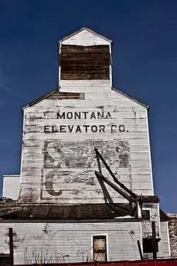 The Historic Montana Elevator Co. elevator next to the tracks. | |
| Country | United States |
| State | Montana |
| County | Judith Basin |
| Area | |
| • Total | 0.10 sq mi (0.26 km2) |
| • Land | 0.10 sq mi (0.26 km2) |
| • Water | 0.00 sq mi (0.00 km2) |
| Population (2020) | |
| • Total | 31 |
| • Density | 310.00/sq mi (119.91/km2) |
| FIPS code | 30-61300 |
| GNIS feature ID | 789423[2] |
U.S. Route 87 runs along the southern side of town. Montana Highway 217's southern terminus intersects Stanford. Big Otter Creek flows through town.
Nearby Sluice Boxes State Park provides rugged recreation. It is a former mining area located along the Belt Creek Canyon.[6]
Climate
According to the Köppen Climate Classification system, Raynesford has a semi-arid climate, abbreviated "BSk" on climate maps.[8]
Media
The Judith Basin Press is the local newspaper.[9] It is published weekly.
References
- "ArcGIS REST Services Directory". United States Census Bureau. Retrieved September 18, 2022.
- U.S. Geological Survey Geographic Names Information System: Raynesford, Montana
- U.S. Geological Survey Geographic Names Information System: Raynesford, Montana
- U.S. Geological Survey Geographic Names Information System: Judith Basin Rural Fire District Raynesford
- U.S. Geological Survey Geographic Names Information System: Raynesford Post Office
- "Sluice Boxes State Park". Fish, Wildlife, and Parks. Retrieved September 4, 2023.
- "Census of Population and Housing". Census.gov. Retrieved June 4, 2016.
- Climate Summary for Raynesford, Montana
- "News". Judith Basin Press. Retrieved September 4, 2023.
Municipalities and communities of Judith Basin County, Montana, United States | ||
|---|---|---|
| City | 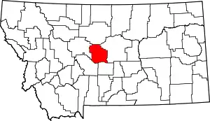 Judith Basin County map | |
| Town | ||
| CDPs | ||
| Other community | ||
| Ghost town | ||