Red Beach, New Zealand
Red Beach is a suburb surrounding the beach of the same name on the Hibiscus Coast, Auckland, New Zealand, at the base of the Whangaparaoa Peninsula. The suburb of Silverdale is to the south-west, and Orewa to the north.
Red Beach | |
|---|---|
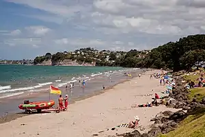 Red Beach in 2010 | |
| Coordinates: 36.606°S 174.698°E | |
| Country | New Zealand |
| City | Auckland |
| Local authority | Auckland Council |
| Electoral ward | Albany ward |
| Local board | Hibiscus and Bays |
| Area | |
| • Land | 430 ha (1,060 acres) |
| Population (June 2023)[2] | |
| • Total | 9,640 |
| Postcode(s) | 0932 |
| (Orewa River) | Orewa | |
| Millwater |
|
(Whangaparaoa Bay) |
| Silverdale | (Weiti River) | Stanmore Bay |
The beach is on the Hauraki Gulf and the suburb is bounded by two estuaries, that of the Weiti River to the south and the Orewa River to the north. The beach is named for its reddish colour.[3] The sand is light brownish-grey in colour and its "red" colour is due to fragments of dark orange-brown, iron-stained, fossil shell. The majority of the iron-stained shells consists of highly fragmented bivalve shells, which are less than 2 cm (0.79 in) across.[3][4]
The Hibiscus Coast Highway runs through the suburb. This was previously State Highway 1[5] and then State Highway 17. The majority of highway traffic now travels along the Northern Motorway inland instead, as the motorway was redesignated as State Highway 1 when an extension was completed in 2009. All road access to the rest of Whangaparaoa Peninsula currently runs through the suburb.
The 44 hectare Peninsula Golf Course, established in 1956, was rezoned for residential development in 2013, despite local opposition[6] and Fletcher Living gained resource consent to build 520 houses on the site in December 2014.[7]
Demographics
Red Beach covers 4.30 km2 (1.66 sq mi)[1] and had an estimated population of 9,640 as of June 2023,[2] with a population density of 2,242 people per km2.
| Year | Pop. | ±% p.a. |
|---|---|---|
| 2006 | 6,423 | — |
| 2013 | 7,551 | +2.34% |
| 2018 | 8,346 | +2.02% |
| Source: [8] | ||
Red Beach had a population of 8,346 at the 2018 New Zealand census, an increase of 795 people (10.5%) since the 2013 census, and an increase of 1,923 people (29.9%) since the 2006 census. There were 3,027 households, comprising 3,975 males and 4,374 females, giving a sex ratio of 0.91 males per female, with 1,548 people (18.5%) aged under 15 years, 1,368 (16.4%) aged 15 to 29, 3,531 (42.3%) aged 30 to 64, and 1,908 (22.9%) aged 65 or older.
Ethnicities were 88.9% European/Pākehā, 7.5% Māori, 2.5% Pacific peoples, 7.3% Asian, and 2.6% other ethnicities. People may identify with more than one ethnicity.
The percentage of people born overseas was 29.7, compared with 27.1% nationally.
Although some people chose not to answer the census's question about religious affiliation, 47.5% had no religion, 42.6% were Christian, 0.1% had Māori religious beliefs, 0.8% were Hindu, 0.3% were Muslim, 0.5% were Buddhist and 1.5% had other religions.
Of those at least 15 years old, 1,554 (22.9%) people had a bachelor's or higher degree, and 990 (14.6%) people had no formal qualifications. 1,488 people (21.9%) earned over $70,000 compared to 17.2% nationally. The employment status of those at least 15 was that 3,177 (46.7%) people were employed full-time, 1,095 (16.1%) were part-time, and 174 (2.6%) were unemployed.[8]
| Name | Area (km2) | Population | Density (per km2) | Households | Median age | Median income |
|---|---|---|---|---|---|---|
| Kingsway | 0.90 | 2,187 | 2,430 | 705 | 37.8 years | $40,100[9] |
| Red Beach West | 1.84 | 2,136 | 1,161 | 789 | 50.3 years | $25,100[10] |
| Red Beach East | 1.56 | 4,023 | 2,579 | 1,533 | 44.9 years | $36,300[11] |
| New Zealand | 37.4 years | $31,800 |
Landmarks and attractions
Popular attractions include:
- The Red Beach Surf Club
- Totara Views
- William Bayes play ground
- Red Beach Shops
Annual events
- Red Beach School Gala
- Streetlight Competition
Education
Red Beach School is a contributing primary (years 1–6) school with a roll of 476 students.[12] The school opened in 1989 covering years 1–8, but reduced its age range when Hibiscus Coast Intermediate opened in 1997 (the intermediate later became part of Whangaparaoa College).[13]
KingsWay School is a state integrated composite (years 1–13) school with a roll of 1695 students.[14][15] The school provides a non-denominational Christian-based education.[16]
Both schools are coeducational. Rolls are as of April 2023.[17]
Notes
- "ArcGIS Web Application". statsnz.maps.arcgis.com. Retrieved 1 June 2022.
- "Population estimate tables - NZ.Stat". Statistics New Zealand. Retrieved 25 October 2023.
- Hayward, B.W., 2020. Mountains, volcanoes, coasts and caves: origins of Aotearoa New Zealand’s natural wonders Auckland, New Zealand, Auckland University Press. 384 pp.
- Hayward, B.W., 2023. Red Beach - What's in a name? Geocene. 32, pp. 16-17.
- Peter Dowling, ed. (2004). Reed New Zealand Atlas. Reed Books. pp. map 11. ISBN 0-7900-0952-8.
- "500-house development at Red Beach tees off locals". The Aucklander. 3 February 2012.
- Trayes, Caralise (28 September 2015). "Red Beach residential development moving". Rodney Times.
- "Statistical area 1 dataset for 2018 Census". Statistics New Zealand. March 2020. Kingsway (113600), Red Beach West (113900) and Red Beach East (114000).
- 2018 Census place summary: Kingsway
- 2018 Census place summary: Red Beach West
- 2018 Census place summary: Red Beach East
- Education Counts: Red Beach School
- "About Our School – General Information". Red Beach School. Retrieved 26 August 2008.
- Education Counts: KingsWay School
- "Kingsway School - 08/11/2017". Education Review Office. Retrieved 19 July 2019.
- "Education Review Report – KingsWay School". Education Review Office. April 2006. Retrieved 26 August 2008.
- "New Zealand Schools Directory". New Zealand Ministry of Education. Retrieved 12 December 2022.
External links
- Red Beach School website
- KingsWay School website
- Photographs of Red Beach held in Auckland Libraries' heritage collections.