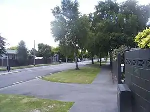
Redwood, Christchurch
Redwood is a suburb located in Christchurch, New Zealand which includes the sub-division of Redwood Springs. The suburb was first named Styx but renamed following a popular vote of local residents in the 1960s after a large Sequoia redwood tree still standing in Prestons Road. The original forest cover was Tōtara and Kahikatea. Redwood has its own community radio station called Good Music FM 107.5 (formerly known as Radio Redwood).
Redwood | |
|---|---|
 Redwood, Christchurch in early summer | |
| Coordinates: 43.47660°S 172.61696°E | |
| Country | New Zealand |
| City | Christchurch |
| Local authority | Christchurch City Council |
| Electoral ward | Papanui |
| Community board | Waipapa Papanui-Innes-Central |
| Area | |
| • Land | 318 ha (786 acres) |
| Population (June 2023)[2] | |
| • Total | 8,260 |
| Northwood | ||
| Casebrook |
|
Marshland |
| Papanui | Northcote | Mairehau |
Demographics
Redwood covers 3.18 km2 (1.23 sq mi).[1] It had an estimated population of 8,260 as of June 2023, with a population density of 2,597 people per km2.
| Year | Pop. | ±% p.a. |
|---|---|---|
| 2006 | 8,331 | — |
| 2013 | 8,112 | −0.38% |
| 2018 | 8,184 | +0.18% |
| Source: [3] | ||
Redwood had a population of 8,184 at the 2018 New Zealand census, an increase of 72 people (0.9%) since the 2013 census, and a decrease of 147 people (−1.8%) since the 2006 census. There were 3,051 households, comprising 3,990 males and 4,194 females, giving a sex ratio of 0.95 males per female, with 1,587 people (19.4%) aged under 15 years, 1,632 (19.9%) aged 15 to 29, 3,705 (45.3%) aged 30 to 64, and 1,260 (15.4%) aged 65 or older.
Ethnicities were 83.4% European/Pākehā, 11.9% Māori, 3.2% Pasifika, 9.2% Asian, and 2.4% other ethnicities. People may identify with more than one ethnicity.
The percentage of people born overseas was 18.2, compared with 27.1% nationally.
Although some people chose not to answer the census's question about religious affiliation, 51.5% had no religion, 37.1% were Christian, 0.4% had Māori religious beliefs, 1.0% were Hindu, 0.8% were Muslim, 0.7% were Buddhist and 1.9% had other religions.
Of those at least 15 years old, 1,047 (15.9%) people had a bachelor's or higher degree, and 1,437 (21.8%) people had no formal qualifications. 984 people (14.9%) earned over $70,000 compared to 17.2% nationally. The employment status of those at least 15 was that 3,354 (50.8%) people were employed full-time, 1,002 (15.2%) were part-time, and 255 (3.9%) were unemployed.[3]
| Name | Area (km2) | Population | Density (per km2) | Households | Median age | Median income |
|---|---|---|---|---|---|---|
| Redwood North | 1.09 | 2,781 | 2,551 | 990 | 39.8 years | $37,000[4] |
| Redwood West | 0.82 | 2,202 | 2,685 | 807 | 35.1 years | $27,400[5] |
| Redwood East | 1.27 | 3,201 | 2,520 | 1,254 | 38.8 years | $33,100[6] |
| New Zealand | 37.4 years | $31,800 |
Education
Redwood School and Northcote School are contributing primary schools catering for years 1 to 6.[7][8] They have rolls of 260 and 136, respectively. Redwood School opened in 1969,[9]: 156 and Northcote in 1960.[9]: 119
References
- "ArcGIS Web Application". statsnz.maps.arcgis.com. Retrieved 11 September 2021.
- "Population estimate tables - NZ.Stat". Statistics New Zealand. Retrieved 25 October 2023.
- "Statistical area 1 dataset for 2018 Census". Statistics New Zealand. March 2020. Redwood North (318600), Redwood West (318800) and Redwood East (319600).
- 2018 Census place summary: Redwood North
- 2018 Census place summary: Redwood West
- 2018 Census place summary: Redwood East
- Education Counts: Redwood School
- Education Counts: Northcote School
- "Miscellaneous Local Historical Information" (PDF). Christchurch City Libraries. Retrieved 11 September 2021.