Rethymno (regional unit)
Rethymno (Greek: Περιφερειακή ενότητα Ρεθύμνου) is one of the four regional units of Crete, Greece. Its capital is the city of Rethymno. Today its main income is tourism. The countryside is also based economically on agriculture and herding.
Rethymno
Περιφερειακή ενότητα Ρεθύμνου | |
|---|---|
 Municipalities of Rethymno regional unit | |
 Rethymno regional unit within Greece | |
| Coordinates: 35°15′N 24°35′E | |
| Country | Greece |
| Region | Crete |
| Capital | Rethymno |
| Area | |
| • Total | 1,496 km2 (578 sq mi) |
| Population (2011) | |
| • Total | 85,609 |
| • Density | 57/km2 (150/sq mi) |
| Time zone | UTC+2 |
| • Summer (DST) | UTC+3 (EEST) |
| Postal codes | 74x xx |
| Area codes | 283x0 |
| ISO 3166 code | GR-93 |
| Car plates | ΡΕ (Rho Epsilon) |
| Website | www |
Administration
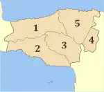
The regional unit Rethymno is subdivided into 5 municipalities. These are (number as in the map in the infobox):[1]
- Agios Vasileios (2)
- Amari (3)
- Anogeia (4)
- Mylopotamos (5)
- Rethymno (1)
Prefecture
The Rethymno prefecture (Greek: Νομός Ρεθύμνου or Ρεθύμνης) was created while Crete was still an autonomous state, and was preserved after the island joined Greece in 1913. As a part of the 2011 Kallikratis government reform, the Rethymno regional unit was created out of the former prefecture. The prefecture had the same territory as the present regional unit. At the same time, the municipalities were reorganised, according to the table below.[1]
| New municipality | Old municipalities | Seat |
|---|---|---|
| Agios Vasileios | Lampi | Spili |
| Foinikas | ||
| Amari | Kourites | Agia Foteini |
| Sivritos | ||
| Anogeia | Anogeia | Anogeia |
| Mylopotamos | Geropotamos | Perama |
| Kouloukonas | ||
| Zoniana | ||
| Rethymno | Rethymno | Rethymno |
| Arkadi | ||
| Lappa | ||
| Nikiforos Fokas |
Provinces
- Rethymno Province - Rethymno
- Agios Vasileios Province - Spili
- Amari Province - Amari
- Mylopotamos Province - Perama
Note: Provinces no longer hold any legal status in Greece.
Main towns
The main towns of the regional unit Rethymno are (ranked by 2011 census population):
- Rethymno 34,300
- Atsipopoulo 4,947
- Anogeia 2,379
