Aukra
Aukra is municipality in Møre og Romsdal county, Norway. It is part of the region of Romsdalen. The administrative centre is the village of Falkhytta, which is part of the Aukrasanden urban area.
Aukra kommune
Akerø herred (historic) | |
|---|---|
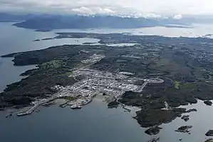 View of the Ormen Lange facilities in Nyhamna | |
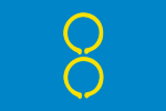 Flag  Møre og Romsdal within Norway | |
 Aukra within Møre og Romsdal | |
| Coordinates: 62°49′43″N 06°50′45″E | |
| Country | Norway |
| County | Møre og Romsdal |
| District | Romsdal |
| Established | 1 Jan 1838 |
| • Created as | Formannskapsdistrikt |
| Administrative centre | Falkhytta |
| Government | |
| • Mayor (2019) | Odd Jørgen Nilssen (H) |
| Area | |
| • Total | 60.65 km2 (23.42 sq mi) |
| • Land | 60.55 km2 (23.38 sq mi) |
| • Water | 0.10 km2 (0.04 sq mi) 0.2% |
| • Rank | #345 in Norway |
| Population (2022) | |
| • Total | 3,518 |
| • Rank | #215 in Norway |
| • Density | 58.1/km2 (150/sq mi) |
| • Change (10 years) | |
| Demonyms | Gossing Aukraværing[1] |
| Official language | |
| • Norwegian form | Nynorsk |
| Time zone | UTC+01:00 (CET) |
| • Summer (DST) | UTC+02:00 (CEST) |
| ISO 3166 code | NO-1547 |
| Website | Official website |
The municipality is made up of the island of Gossa as well as many small surrounding islands, plus a small area around the village of Hollingen across the Julsundet strait on the mainland Romsdal peninsula. Some of the main population centers include the villages of Hollingen, Aukrasanden, Varhaugvika, and Røssøyvågen. Nyhamna is a major industrial area in Aukra.
The 61-square-kilometre (24 sq mi) municipality is the 345th largest by area out of the 356 municipalities in Norway. Aukra is the 215th most populous municipality in Norway with a population of 3,518. The municipality's population density is 58.1 inhabitants per square kilometre (150/sq mi) and its population has increased by 7% over the previous 10-year period.[3][4]
General information
The municipality of Akerø was established on 1 January 1838 (see formannskapsdistrikt law). In 1840, most of Akerø on the Romsdal peninsula was separated to form the municipality of Frænen. On 1 January 1867, the islands that are located to the west of Gossa (population: 601) were separated to become the new Sandøy Municipality. On 1 January 1924, the southern part of the municipality (Otrøya and several other islands) were separated to form the new municipality of Sør-Aukra, and the remainder of the municipality was renamed Nord-Aukra.[5]
During the 1960s, there were many municipal mergers across Norway due to the work of the Schei Committee. On 1 January 1964, the Mordal area of Nord-Aukra (population: 77) was transferred to Molde Municipality. On 1 January 1965, Nord- was dropped from the name of the municipality, so it was then just called Aukra.[5]
On 1 January 2020, the uninhabited islands of Lyngværet and the island of Orta (population: 11) were transferred from Sandøy Municipality to Aukra.[6]
Name
The municipality (originally the parish) is named after the old Aukra farm (Old Norse: Aukrin) since the first Aukra Church was built there. The first element is akr which means "field" or "acre". The last element is vin which means "field" or "acre". Prior to 1918, the name was written Akerø or Agerø.[7]
Coat of arms
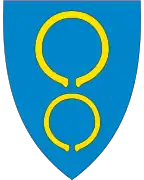
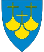
The coat of arms was granted on 22 May 1987. The official blazon is "Azure, two bracelets Or" (Norwegian: På blå grunn to gull ringar, 1-1). This means the arms have a blue field (background) and the charge is two Bronze Age bracelets. The charge has a tincture of Or which means it is commonly colored yellow, but if it is made out of metal, then gold is used. The bracelets are based on an archaeological finding of two bracelets in Aukra in 1936. The rings date back to the year 1000 BC, during the Bronze Age. There are no other such pairs found in Norway and only one somewhat similar in southern Sweden. The rings are 8 centimetres (3.1 in) in diameter and each one is made of 65 grams (2.3 oz) of gold. The rings thus symbolize the long tradition of habitation in the area. The fact that there are two, also symbolizes one for the island part of the municipality and the other for the mainland part. The blue and gold colors symbolize the sunset over the ocean. The arms were designed by Jarle Skuseth who based it off an idea by Knut Rød. The municipal flag has the same design as the coat of arms.[8][9][10]
Churches
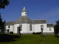
The Church of Norway has one parish (sokn) within the municipality of Aukra. It is part of the Molde domprosti (arch-deanery) in the Diocese of Møre.
| Parish (sokn) | Church name | Location of the church | Year built |
|---|---|---|---|
| Aukra | Aukra Church | Aukrasanden | 1835 |
History
Aukra is the site of a shipwreck and rescue operation, when the cargo ship Rokta on 4 April 1938. The monument of Rokta is situated on Rindarøy island with a view of Galleskjæra where the Rokta sank.
Government
All municipalities in Norway are responsible for primary education (through 10th grade), outpatient health services, senior citizen services, welfare and other social services, zoning, economic development, and municipal roads and utilities. The municipality is governed by a municipal council of directly elected representatives. The mayor is indirectly elected by a vote of the municipal council.[11] The municipality falls under the Møre og Romsdal District Court and the Frostating Court of Appeal.
Municipal council
The municipal council (Kommunestyre) of Aukra is made up of 21 representatives that are elected to four year terms. The party breakdown of the council is as follows:
| Party Name (in Nynorsk) | Number of representatives | |
|---|---|---|
| Labour Party (Arbeidarpartiet) | 5 | |
| Progress Party (Framstegspartiet) | 1 | |
| Conservative Party (Høgre) | 5 | |
| Christian Democratic Party (Kristeleg Folkeparti) | 4 | |
| Centre Party (Senterpartiet) | 4 | |
| Socialist Left Party (Sosialistisk Venstreparti) | 1 | |
| Liberal Party (Venstre) | 1 | |
| Total number of members: | 21 | |
| Party Name (in Nynorsk) | Number of representatives | |
|---|---|---|
| Labour Party (Arbeidarpartiet) | 7 | |
| Progress Party (Framstegspartiet) | 1 | |
| Conservative Party (Høgre) | 5 | |
| Christian Democratic Party (Kristeleg Folkeparti) | 3 | |
| Centre Party (Senterpartiet) | 2 | |
| Liberal Party (Venstre) | 2 | |
| Aukra List (Aukralista) | 1 | |
| Total number of members: | 21 | |
| Party Name (in Nynorsk) | Number of representatives | |
|---|---|---|
| Labour Party (Arbeidarpartiet) | 7 | |
| Progress Party (Framstegspartiet) | 2 | |
| Conservative Party (Høgre) | 3 | |
| Christian Democratic Party (Kristeleg Folkeparti) | 3 | |
| Centre Party (Senterpartiet) | 1 | |
| Socialist Left Party (Sosialistisk Venstreparti) | 1 | |
| Liberal Party (Venstre) | 1 | |
| Aukra List (Aukralista) | 3 | |
| Total number of members: | 21 | |
| Party Name (in Nynorsk) | Number of representatives | |
|---|---|---|
| Labour Party (Arbeidarpartiet) | 5 | |
| Progress Party (Framstegspartiet) | 4 | |
| Conservative Party (Høgre) | 3 | |
| Christian Democratic Party (Kristeleg Folkeparti) | 4 | |
| Centre Party (Senterpartiet) | 2 | |
| Socialist Left Party (Sosialistisk Venstreparti) | 1 | |
| Liberal Party (Venstre) | 2 | |
| Total number of members: | 21 | |
| Party Name (in Nynorsk) | Number of representatives | |
|---|---|---|
| Labour Party (Arbeidarpartiet) | 4 | |
| Progress Party (Framstegspartiet) | 2 | |
| Conservative Party (Høgre) | 3 | |
| Christian Democratic Party (Kristeleg Folkeparti) | 7 | |
| Centre Party (Senterpartiet) | 1 | |
| Socialist Left Party (Sosialistisk Venstreparti) | 2 | |
| Liberal Party (Venstre) | 2 | |
| Total number of members: | 21 | |
| Party Name (in Nynorsk) | Number of representatives | |
|---|---|---|
| Labour Party (Arbeidarpartiet) | 5 | |
| Conservative Party (Høgre) | 3 | |
| Christian Democratic Party (Kristeleg Folkeparti) | 6 | |
| Centre Party (Senterpartiet) | 4 | |
| Socialist Left Party (Sosialistisk Venstreparti) | 1 | |
| Liberal Party (Venstre) | 2 | |
| Total number of members: | 21 | |
| Party Name (in Nynorsk) | Number of representatives | |
|---|---|---|
| Labour Party (Arbeidarpartiet) | 5 | |
| Conservative Party (Høgre) | 2 | |
| Christian Democratic Party (Kristeleg Folkeparti) | 4 | |
| Centre Party (Senterpartiet) | 7 | |
| Socialist Left Party (Sosialistisk Venstreparti) | 1 | |
| Liberal Party (Venstre) | 2 | |
| Total number of members: | 21 | |
| Party Name (in Nynorsk) | Number of representatives | |
|---|---|---|
| Labour Party (Arbeidarpartiet) | 4 | |
| Conservative Party (Høgre) | 3 | |
| Christian Democratic Party (Kristeleg Folkeparti) | 4 | |
| Centre Party (Senterpartiet) | 6 | |
| Socialist Left Party (Sosialistisk Venstreparti) | 2 | |
| Liberal Party (Venstre) | 2 | |
| Total number of members: | 21 | |
| Party Name (in Nynorsk) | Number of representatives | |
|---|---|---|
| Labour Party (Arbeidarpartiet) | 7 | |
| Conservative Party (Høgre) | 5 | |
| Christian Democratic Party (Kristeleg Folkeparti) | 4 | |
| Centre Party (Senterpartiet) | 2 | |
| Liberal Party (Venstre) | 3 | |
| Total number of members: | 21 | |
| Party Name (in Nynorsk) | Number of representatives | |
|---|---|---|
| Labour Party (Arbeidarpartiet) | 7 | |
| Conservative Party (Høgre) | 3 | |
| Christian Democratic Party (Kristeleg Folkeparti) | 5 | |
| Centre Party (Senterpartiet) | 3 | |
| Liberal Party (Venstre) | 3 | |
| Total number of members: | 21 | |
| Party Name (in Nynorsk) | Number of representatives | |
|---|---|---|
| Labour Party (Arbeidarpartiet) | 4 | |
| Conservative Party (Høgre) | 4 | |
| Christian Democratic Party (Kristeleg Folkeparti) | 5 | |
| Centre Party (Senterpartiet) | 4 | |
| Liberal Party (Venstre) | 2 | |
| Total number of members: | 19 | |
| Party Name (in Nynorsk) | Number of representatives | |
|---|---|---|
| Labour Party (Arbeidarpartiet) | 3 | |
| Conservative Party (Høgre) | 1 | |
| Christian Democratic Party (Kristeleg Folkeparti) | 5 | |
| Centre Party (Senterpartiet) | 5 | |
| Liberal Party (Venstre) | 2 | |
| Non-party list (Upolitisk Liste) | 3 | |
| Total number of members: | 19 | |
| Party Name (in Nynorsk) | Number of representatives | |
|---|---|---|
| Labour Party (Arbeidarpartiet) | 4 | |
| Conservative Party (Høgre) | 1 | |
| Christian Democratic Party (Kristeleg Folkeparti) | 5 | |
| Centre Party (Senterpartiet) | 6 | |
| Liberal Party (Venstre) | 3 | |
| Total number of members: | 19 | |
| Party Name (in Nynorsk) | Number of representatives | |
|---|---|---|
| Labour Party (Arbeidarpartiet) | 5 | |
| Conservative Party (Høgre) | 1 | |
| Christian Democratic Party (Kristeleg Folkeparti) | 5 | |
| Centre Party (Senterpartiet) | 4 | |
| Liberal Party (Venstre) | 4 | |
| Total number of members: | 19 | |
| Party Name (in Nynorsk) | Number of representatives | |
|---|---|---|
| Labour Party (Arbeidarpartiet) | 4 | |
| Christian Democratic Party (Kristeleg Folkeparti) | 4 | |
| Centre Party (Senterpartiet) | 4 | |
| Local List(s) (Lokale lister) | 5 | |
| Total number of members: | 17 | |
| Party Name (in Nynorsk) | Number of representatives | |
|---|---|---|
| Labour Party (Arbeidarpartiet) | 3 | |
| Christian Democratic Party (Kristeleg Folkeparti) | 4 | |
| Local List(s) (Lokale lister) | 10 | |
| Total number of members: | 17 | |
| Party Name (in Nynorsk) | Number of representatives | |
|---|---|---|
| Labour Party (Arbeidarpartiet) | 3 | |
| Christian Democratic Party (Kristeleg Folkeparti) | 4 | |
| Local List(s) (Lokale lister) | 10 | |
| Total number of members: | 17 | |
| Party Name (in Nynorsk) | Number of representatives | |
|---|---|---|
| Labour Party (Arbeidarpartiet) | 3 | |
| Local List(s) (Lokale lister) | 13 | |
| Total number of members: | 16 | |
| Party Name (in Nynorsk) | Number of representatives | |
|---|---|---|
| Labour Party (Arbeidarpartiet) | 2 | |
| Local List(s) (Lokale lister) | 14 | |
| Total number of members: | 16 | |
| Party Name (in Nynorsk) | Number of representatives | |
|---|---|---|
| Labour Party (Arbeidarpartiet) | 4 | |
| Christian Democratic Party (Kristeleg Folkeparti) | 1 | |
| Local List(s) (Lokale lister) | 11 | |
| Total number of members: | 16 | |
| Party Name (in Nynorsk) | Number of representatives | |
|---|---|---|
| Labour Party (Arbeidarpartiet) | 2 | |
| Local List(s) (Lokale lister) | 14 | |
| Total number of members: | 16 | |
| Note: Due to the German occupation of Norway during World War II, no elections were held for new municipal councils until after the war ended in 1945. | ||
Mayors
The mayors of Aukra (incomplete list):
- 1945–1947: Ivar Kornelius Eikrem (Ap)
- 1992-1999: Andreas Horrem (Sp)
- 1999-2007: Aud Mork (KrF)
- 2007-2019: Bernhard Riksfjord (Ap)
- 2019–present: Odd Jørgen Nilssen (H)
Economy
The Nyhamna industrial area on the northeastern part of the island of Gossa in Aukra is the location from where the Langeled pipeline, transporting natural gas from the enormous Ormen Lange gas field to the United Kingdom, came onstream in 2007.
Aukra Auto runs the bus service on the island of Gossa.
Notable people
- Jonas Danilssønn Ramus (1649 in Aukra - 1718) a Norwegian priest, author and historian
- Anton Beinset (1894 in Aukra – 1963) a journalist, newspaper editor, short story writer, crime fiction writer and politician
- Iver Horrem (born 1977 in Aukra) a Norwegian professional beach volleyball player
- Emilie Nautnes (born 1999 in Aukra) footballer, plays for the Norway women's national football team
Gallery
 Aukra kirke
.jpg.webp) Roktabautaen
Roktabautaen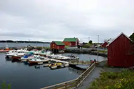 Røssøyvågen on Gossen island, Aukra
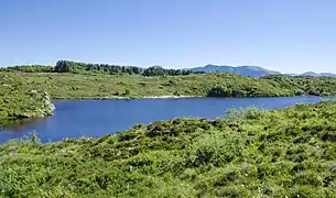 Smågevatnet Gossen
References
- "Navn på steder og personer: Innbyggjarnamn" (in Norwegian). Språkrådet.
- "Forskrift om målvedtak i kommunar og fylkeskommunar" (in Norwegian). Lovdata.no.
- Statistisk sentralbyrå. "Table: 06913: Population 1 January and population changes during the calendar year (M)" (in Norwegian).
- Statistisk sentralbyrå. "09280: Area of land and fresh water (km²) (M)" (in Norwegian).
- Jukvam, Dag (1999). Historisk oversikt over endringer i kommune- og fylkesinndelingen (PDF) (in Norwegian). Statistisk sentralbyrå. ISBN 9788253746845.
- "Vedtar grensejustering mellom Sandøy og Aukra kommuner" (in Norwegian). 2 July 2018. Retrieved 1 January 2020.
- Rygh, Oluf (1908). Norske gaardnavne: Romsdals amt (in Norwegian) (13 ed.). Kristiania, Norge: W. C. Fabritius & sønners bogtrikkeri. p. 300.
- "Civic heraldry of Norway - Norske Kommunevåpen". Heraldry of the World. Retrieved 13 April 2023.
- "Aukra, Møre og Romsdal (Norway)". Flags of the World. Retrieved 13 April 2023.
- "Godkjenning av våpen og flagg". Lovdata.no (in Norwegian). Norges kommunal- og arbeidsdepartementet. 22 May 1987. Retrieved 13 April 2023.
- Hansen, Tore; Vabo, Signy Irene, eds. (20 September 2022). "kommunestyre". Store norske leksikon (in Norwegian). Kunnskapsforlaget. Retrieved 14 October 2022.
- "Tall for hele Norge: Kommunestyrevalg 2019" (in Norwegian). Statistics Norway. Retrieved 5 October 2019.
- "Table: 04813: Members of the local councils, by party/electoral list at the Municipal Council election (M)" (in Norwegian). Statistics Norway.
- "Tall for Norge: Kommunestyrevalg 2011 - Møre og Romsdal" (in Norwegian). Statistics Norway. Retrieved 19 October 2019.
- "Kommunestyrevalget 1995" (PDF) (in Norwegian). Oslo-Kongsvinger: Statistisk sentralbyrå. 1996. Retrieved 26 April 2020.
- "Kommunestyrevalget 1991" (PDF) (in Norwegian). Oslo-Kongsvinger: Statistisk sentralbyrå. 1993. Retrieved 26 April 2020.
- "Kommunestyrevalget 1987" (PDF) (in Norwegian). Oslo-Kongsvinger: Statistisk sentralbyrå. 1988. Retrieved 26 April 2020.
- "Kommunestyrevalget 1983" (PDF) (in Norwegian). Oslo-Kongsvinger: Statistisk sentralbyrå. 1984. Retrieved 26 April 2020.
- "Kommunestyrevalget 1979" (PDF) (in Norwegian). Oslo: Statistisk sentralbyrå. 1979. Retrieved 26 April 2020.
- "Kommunevalgene 1975" (PDF) (in Norwegian). Oslo: Statistisk sentralbyrå. 1977. Retrieved 26 April 2020.
- "Kommunevalgene 1972" (PDF) (in Norwegian). Oslo: Statistisk sentralbyrå. 1973. Retrieved 26 April 2020.
- "Kommunevalgene 1967" (PDF) (in Norwegian). Oslo: Statistisk sentralbyrå. 1967. Retrieved 26 April 2020.
- "Kommunevalgene 1963" (PDF) (in Norwegian). Oslo: Statistisk sentralbyrå. 1964. Retrieved 26 April 2020.
- "Kommunevalgene og Ordførervalgene 1959" (PDF) (in Norwegian). Oslo: Statistisk sentralbyrå. 1960. Retrieved 26 April 2020.
- "Kommunevalgene og Ordførervalgene 1955" (PDF) (in Norwegian). Oslo: Statistisk sentralbyrå. 1957. Retrieved 26 April 2020.
- "Kommunevalgene og Ordførervalgene 1951" (PDF) (in Norwegian). Oslo: Statistisk sentralbyrå. 1952. Retrieved 26 April 2020.
- "Kommunevalgene og Ordførervalgene 1947" (PDF) (in Norwegian). Oslo: Statistisk sentralbyrå. 1948. Retrieved 26 April 2020.
- "Kommunevalgene og Ordførervalgene 1945" (PDF) (in Norwegian). Oslo: Statistisk sentralbyrå. 1947. Retrieved 26 April 2020.
- "Kommunevalgene og Ordførervalgene 1937" (PDF) (in Norwegian). Oslo: Statistisk sentralbyrå. 1938. Retrieved 26 April 2020.
External links
- Municipal fact sheet from Statistics Norway (in Norwegian)
 Møre og Romsdal travel guide from Wikivoyage
Places adjacent to Aukra | ||||||||||||||||
|---|---|---|---|---|---|---|---|---|---|---|---|---|---|---|---|---|
| ||||||||||||||||
Møre og Romsdal county, Norway | |||
|---|---|---|---|
| |||
 | Towns and cities |
|  |
| Municipalities | |||