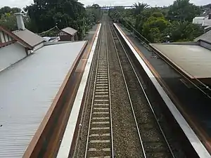
Ripponlea railway station
Ripponlea railway station is located on the Sandringham line in Victoria, Australia. It serves the south-eastern Melbourne suburb of Ripponlea, and opened on 1 May 1912.[4]
Ripponlea | ||||||||||||||||||||||||||||||||||||||||||||||||||||||||||||||||||||||
|---|---|---|---|---|---|---|---|---|---|---|---|---|---|---|---|---|---|---|---|---|---|---|---|---|---|---|---|---|---|---|---|---|---|---|---|---|---|---|---|---|---|---|---|---|---|---|---|---|---|---|---|---|---|---|---|---|---|---|---|---|---|---|---|---|---|---|---|---|---|---|
| PTV commuter rail station | ||||||||||||||||||||||||||||||||||||||||||||||||||||||||||||||||||||||
 Northbound view, November 2021 | ||||||||||||||||||||||||||||||||||||||||||||||||||||||||||||||||||||||
| General information | ||||||||||||||||||||||||||||||||||||||||||||||||||||||||||||||||||||||
| Location | Glen Eira Road, Ripponlea, Victoria 3185 City of Port Phillip Australia | |||||||||||||||||||||||||||||||||||||||||||||||||||||||||||||||||||||
| Coordinates | 37°52′33″S 144°59′42″E | |||||||||||||||||||||||||||||||||||||||||||||||||||||||||||||||||||||
| Owned by | VicTrack | |||||||||||||||||||||||||||||||||||||||||||||||||||||||||||||||||||||
| Operated by | Metro Trains | |||||||||||||||||||||||||||||||||||||||||||||||||||||||||||||||||||||
| Line(s) | Sandringham | |||||||||||||||||||||||||||||||||||||||||||||||||||||||||||||||||||||
| Distance | 9.83 kilometres from Southern Cross | |||||||||||||||||||||||||||||||||||||||||||||||||||||||||||||||||||||
| Platforms | 2 side | |||||||||||||||||||||||||||||||||||||||||||||||||||||||||||||||||||||
| Tracks | 2 | |||||||||||||||||||||||||||||||||||||||||||||||||||||||||||||||||||||
| Connections |
| |||||||||||||||||||||||||||||||||||||||||||||||||||||||||||||||||||||
| Construction | ||||||||||||||||||||||||||||||||||||||||||||||||||||||||||||||||||||||
| Structure type | Ground | |||||||||||||||||||||||||||||||||||||||||||||||||||||||||||||||||||||
| Bicycle facilities | Yes | |||||||||||||||||||||||||||||||||||||||||||||||||||||||||||||||||||||
| Accessible | Yes—step free access | |||||||||||||||||||||||||||||||||||||||||||||||||||||||||||||||||||||
| Other information | ||||||||||||||||||||||||||||||||||||||||||||||||||||||||||||||||||||||
| Status | Operational, host station | |||||||||||||||||||||||||||||||||||||||||||||||||||||||||||||||||||||
| Station code | RIP | |||||||||||||||||||||||||||||||||||||||||||||||||||||||||||||||||||||
| Fare zone | Myki Zone 1 | |||||||||||||||||||||||||||||||||||||||||||||||||||||||||||||||||||||
| Website | Public Transport Victoria | |||||||||||||||||||||||||||||||||||||||||||||||||||||||||||||||||||||
| History | ||||||||||||||||||||||||||||||||||||||||||||||||||||||||||||||||||||||
| Opened | 1 May 1912 | |||||||||||||||||||||||||||||||||||||||||||||||||||||||||||||||||||||
| Electrified | 1500 V DC overhead (May 1919) | |||||||||||||||||||||||||||||||||||||||||||||||||||||||||||||||||||||
| Passengers | ||||||||||||||||||||||||||||||||||||||||||||||||||||||||||||||||||||||
| 2005–2006 | 544,171[1] | |||||||||||||||||||||||||||||||||||||||||||||||||||||||||||||||||||||
| 2006–2007 | 582,849[1] | |||||||||||||||||||||||||||||||||||||||||||||||||||||||||||||||||||||
| 2007–2008 | 614,903[1] | |||||||||||||||||||||||||||||||||||||||||||||||||||||||||||||||||||||
| 2008–2009 | 675,480[2] | |||||||||||||||||||||||||||||||||||||||||||||||||||||||||||||||||||||
| 2009–2010 | 718,704[2] | |||||||||||||||||||||||||||||||||||||||||||||||||||||||||||||||||||||
| 2010–2011 | 708,724[2] | |||||||||||||||||||||||||||||||||||||||||||||||||||||||||||||||||||||
| 2011–2012 | 659,004[2] | |||||||||||||||||||||||||||||||||||||||||||||||||||||||||||||||||||||
| 2012–2013 | Not measured[2] | |||||||||||||||||||||||||||||||||||||||||||||||||||||||||||||||||||||
| 2013–2014 | 727,060[2] | |||||||||||||||||||||||||||||||||||||||||||||||||||||||||||||||||||||
| 2014–2015 | 714,429[1] | |||||||||||||||||||||||||||||||||||||||||||||||||||||||||||||||||||||
| 2015–2016 | 788,960[2] | |||||||||||||||||||||||||||||||||||||||||||||||||||||||||||||||||||||
| 2016–2017 | 748,125[2] | |||||||||||||||||||||||||||||||||||||||||||||||||||||||||||||||||||||
| 2017–2018 | 747,752[2] | |||||||||||||||||||||||||||||||||||||||||||||||||||||||||||||||||||||
| 2018–2019 | 656,564[2] | |||||||||||||||||||||||||||||||||||||||||||||||||||||||||||||||||||||
| 2019–2020 | 531,200[2] | |||||||||||||||||||||||||||||||||||||||||||||||||||||||||||||||||||||
| 2020–2021 | 244,200[2] | |||||||||||||||||||||||||||||||||||||||||||||||||||||||||||||||||||||
| 2021–2022 | 276,600[3] | |||||||||||||||||||||||||||||||||||||||||||||||||||||||||||||||||||||
| Services | ||||||||||||||||||||||||||||||||||||||||||||||||||||||||||||||||||||||
| ||||||||||||||||||||||||||||||||||||||||||||||||||||||||||||||||||||||
| ||||||||||||||||||||||||||||||||||||||||||||||||||||||||||||||||||||||
The station is located at the up (northern) end of the Glen Eira Road level crossing, with station access from Glen Eira Road, Oak Grove and Morres Street.
History
Opening on 1 May 1912, Ripponlea station, like the suburb itself, was named after the Rippon Lea Estate, which was formed by Frederick Thomas Sargood, businessman and a member of Parliament for the Victorian Legislative Council between 1874–1880 and 1882–1901, and a senator for Victoria between 1901 and 1903.[5][6]
In 1960, boom barriers replaced interlocked gates at the Glen Eira Road level crossing,[7] with the signal box protecting the level crossing also abolished during that time.[4]
Platforms and services
Ripponlea has two side platforms. Platform 1 has a large weatherboard building, with a smaller weatherboard building on Platform 2. There is a footbridge immediately south of the station buildings, which connects the two platforms, and allows pedestrians to cross the railway tracks.
It is served by Sandringham line trains.[8]
Platform 1:
- Sandringham line all stations services to Flinders Street
Platform 2:
- Sandringham line all stations services to Sandringham
Transport links
CDC Melbourne operates one bus route via Ripponlea station, under contract to Public Transport Victoria:
- 623 : Glen Waverley station – St Kilda[9]
Yarra Trams operates one route via Ripponlea station:
Gallery
 Northbound view from the Glen Eira Road level crossing, April 2005
 Station front and entrance to Platform 1, November 2021
References
- Estimated Annual Patronage by Network Segment Financial Year 2005-2006 to 2018-19 Department of Transport
- Railway station and tram stop patronage in Victoria for 2008-2021 Philip Mallis
- Annual metropolitan train station patronage (station entries) Data Vic
- "Ripponlea". vicsig.net. Retrieved 20 January 2023.
- "Ripponlea". Victorian Places. Retrieved 20 January 2023.
- First, Jamie (7 January 2014). "The A-Z story of Melbourne's suburbs". Herald Sun. Retrieved 20 January 2023.
- John Sinnatt (January 1990). "Level Crossing Protection". Somersault. Signalling Record Society Victoria. pp. 9–17.
- "Sandringham Line". Public Transport Victoria.
- "623 Glen Waverley - St Kilda via Mount Waverley & Chadstone & Carnegie". Public Transport Victoria.
- "67 Melbourne University - Carnegie". Public Transport Victoria.
External links
- Melway map at street-directory.com.au