Rivière-Pilote
Rivière-Pilote (French pronunciation: [ʁivjɛʁ pilɔt]; Martinican Creole: Lavièpilot or Wivièpilot) is a town and commune in the French overseas department of Martinique.
Rivière-Pilote | |
|---|---|
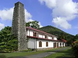 The Ecomuseum of Martinique in Rivière-Pilote | |
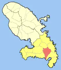 Location of the commune (in red) within Martinique | |
Location of Rivière-Pilote | |
| Coordinates: 14°29′N 60°54′W | |
| Country | France |
| Overseas region and department | Martinique |
| Arrondissement | Le Marin |
| Intercommunality | CA Espace Sud de la Martinique |
| Government | |
| • Mayor (2020–2026) | Jean-François Beaunol[1] |
| Area 1 | 35.78 km2 (13.81 sq mi) |
| Population | 11,675 |
| • Density | 330/km2 (850/sq mi) |
| Time zone | UTC−04:00 (AST) |
| INSEE/Postal code | 97220 /97211 |
| Elevation | 0–372 m (0–1,220 ft) |
| 1 French Land Register data, which excludes lakes, ponds, glaciers > 1 km2 (0.386 sq mi or 247 acres) and river estuaries. | |
The village is situated on the southern end of Martinique, between the village of Sainte-Luce and the town of Le Marin which is a popular haven for yachts. Rivière-Pilote lies inland on the River Grande Pilote which drains the southern slopes of the mountainous Parc Naturel Regional. The village is predominantly one- or two-storey houses with a few small shops and cafes or bars.
Population
| Year | Pop. | ±% p.a. |
|---|---|---|
| 1967 | 12,027 | — |
| 1974 | 11,064 | −1.19% |
| 1982 | 11,249 | +0.21% |
| 1990 | 12,617 | +1.44% |
| 1999 | 13,057 | +0.38% |
| 2007 | 13,621 | +0.53% |
| 2012 | 12,680 | −1.42% |
| 2017 | 11,935 | −1.20% |
| Source: INSEE[3] | ||
References
- "Répertoire national des élus: les maires". data.gouv.fr, Plateforme ouverte des données publiques françaises (in French). 2 December 2020.
- "Populations légales 2020". The National Institute of Statistics and Economic Studies. 29 December 2022.
- Population en historique depuis 1968, INSEE
Wikimedia Commons has media related to Rivière-Pilote.
This article is issued from Wikipedia. The text is licensed under Creative Commons - Attribution - Sharealike. Additional terms may apply for the media files.