Rochford, Victoria
Rochford is a locality in the Macedon Ranges Shire, in Victoria, Australia, on the Lancefield-Woodend Road (now signposted as the Rochford Road).
| Rochford Victoria | |||||||||||||||
|---|---|---|---|---|---|---|---|---|---|---|---|---|---|---|---|
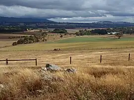 View over Rochford, looking west | |||||||||||||||
 Rochford | |||||||||||||||
| Coordinates | 37°19′S 144°41′E | ||||||||||||||
| Population | 71 (SAL 2016)[1][2] | ||||||||||||||
| Established | 1860 | ||||||||||||||
| Postcode(s) | 3442 | ||||||||||||||
| Elevation | 550 m (1,804 ft) | ||||||||||||||
| LGA(s) | Shire of Macedon Ranges | ||||||||||||||
| State electorate(s) | Macedon | ||||||||||||||
| Federal division(s) | McEwen | ||||||||||||||
| |||||||||||||||
The district once contained a number of public and religious buildings, all of which now appear to have been removed or demolished. These included a Public Hall, Anglican Church, Presbyterian Church, and tennis courts.[3]
Rochford Post Office opened on 10 March 1863 and closed in 1965.[4]
The 1857 red brick building & former 1870 principal's residence of the former Rochford North School (State School 540)[3] is still standing and is now a privately owned luxury holiday rental.[5]
References
- Australian Bureau of Statistics (27 June 2017). "Rochford (Suburb and Locality)". Australian Census 2016.
- Australian Bureau of Statistics (27 June 2017). "Rochford (Suburb and Locality)". Australian Census 2016 QuickStats. Retrieved 28 June 2022.
- Smith, Gavin (1994). All Wild and Lonely Bush. Romsey: Shire of Romsey Book Committee. ISBN 0-646-23834-5.
- Phoenix Auctions History. "Post Office List". Retrieved 19 January 2021.
- Rochford Schoolhouse
Localities in the Shire of Macedon Ranges | ||
|---|---|---|
| City | | |
| Town | ||
| Locality |
| |
^ - Territory divided with another LGA | ||
This article is issued from Wikipedia. The text is licensed under Creative Commons - Attribution - Sharealike. Additional terms may apply for the media files.