Rongchang District
Rongchang District (simplified Chinese: 荣昌区; traditional Chinese: 榮昌區; pinyin: Róngchāng Qū) is a district of Chongqing Municipality, China, bordering Sichuan province to the west.
Rongchang
荣昌区 | |
|---|---|
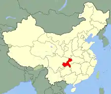
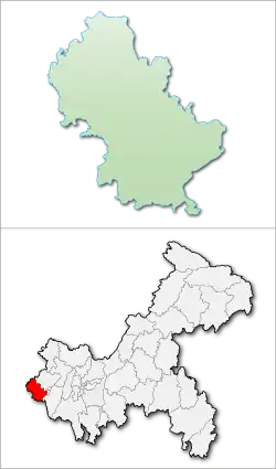 Location of Rongchang in Chongqing | |
| Coordinates: 29.4281°N 105.598°E | |
| Country | People's Republic of China |
| Municipality | Chongqing |
| Area | |
| • Total | 1,079 km2 (417 sq mi) |
| Population (2010) | |
| • Total | 661,300 |
| • Density | 610/km2 (1,600/sq mi) |
| Time zone | UTC+8 (China Standard) |
The district, with a population of 800,000, is located in the west of Chongqing.
Administration
| Name | Chinese (S) | Hanyu Pinyin | Population (2010)[1] | Area (km2) |
|---|---|---|---|---|
| Changyuan Subdistrict | 昌元街道 | Chāngyuán Jiēdào | 58,042 | 63 |
| Changzhou Subdistrict | 昌州街道 | Chāngzhōu Jiēdào | 33,584 | 68.56 |
| Guangshun Subdistrict | 广顺街道 | Guǎngshùn Jiēdào | 24,502 | 39.8 |
| Shuanghe Subdistrict | 双河街道 | Shuānghé Jiēdào | 25,070 | 88.5 |
| Anfu Subdistrict | 安富街道 | Ānfù Jiēdào | 19,126 | 61 |
| Fenggao Subdistrict | 峰高街道 | Fēnggāo Jiēdào | 15,962 | 62 |
| Zhisheng town | 直升镇 | Zhíshēng Zhèn | 6,485 | 34 |
| Lukong town | 路孔镇 | Lùkǒng Zhèn | 5,428 | 25 |
| Qingjiang town | 清江镇 | Qīngjiāng Zhèn | 4,917 | 21 |
| Renyi town | 仁义镇 | Rényì Zhèn | 19,327 | 79 |
| Hebao town | 河包镇 | Hébāo Zhèn | 14,077 | 69 |
| Guchang town | 古昌镇 | Gǔchāng Zhèn | 9,325 | 31 |
| Wujia town | 吴家镇 | Wújiā Zhèn | 17,329 | 48 |
| Guansheng town | 观胜镇 | Guānshèng Zhèn | 6,674 | 42.5 |
| Tonggu town | 铜鼓镇 | Tónggǔ Zhèn | 5,795 | 35 |
| Qingliu town | 清流镇 | Qīngliú Zhèn | 4,708 | 29 |
| Panlong town | 盘龙镇 | Pánlóng Zhèn | 25,796 | 126 |
| Yuanjue town | 远觉镇 | Yuǎnjué Zhèn | 4,922 | 27 |
| Qingsheng town | 清升镇 | Qīngshēng Zhèn | 6,723 | 32.14 |
| Ronglong town | 荣隆镇 | Rónglóng Zhèn | 16,474 | 68 |
| Longji town | 龙集镇 | Lóngjí Zhèn | 5,100 | 21 |
Climate
| Climate data for Rongchang (1991–2020 normals, extremes 1981–2010) | |||||||||||||
|---|---|---|---|---|---|---|---|---|---|---|---|---|---|
| Month | Jan | Feb | Mar | Apr | May | Jun | Jul | Aug | Sep | Oct | Nov | Dec | Year |
| Record high °C (°F) | 18.0 (64.4) |
24.2 (75.6) |
32.7 (90.9) |
34.8 (94.6) |
36.9 (98.4) |
36.5 (97.7) |
39.0 (102.2) |
42.0 (107.6) |
41.5 (106.7) |
35.0 (95.0) |
25.5 (77.9) |
19.6 (67.3) |
42.0 (107.6) |
| Average high °C (°F) | 10.0 (50.0) |
13.2 (55.8) |
18.1 (64.6) |
23.5 (74.3) |
26.9 (80.4) |
28.9 (84.0) |
32.3 (90.1) |
32.6 (90.7) |
27.5 (81.5) |
21.3 (70.3) |
16.8 (62.2) |
11.2 (52.2) |
21.9 (71.3) |
| Daily mean °C (°F) | 7.2 (45.0) |
9.6 (49.3) |
13.8 (56.8) |
18.7 (65.7) |
22.1 (71.8) |
24.6 (76.3) |
27.5 (81.5) |
27.4 (81.3) |
23.2 (73.8) |
18.1 (64.6) |
13.6 (56.5) |
8.6 (47.5) |
17.9 (64.2) |
| Average low °C (°F) | 5.2 (41.4) |
7.2 (45.0) |
10.8 (51.4) |
15.2 (59.4) |
18.6 (65.5) |
21.5 (70.7) |
24.0 (75.2) |
23.8 (74.8) |
20.4 (68.7) |
16.0 (60.8) |
11.5 (52.7) |
6.8 (44.2) |
15.1 (59.2) |
| Record low °C (°F) | −1.8 (28.8) |
−1.0 (30.2) |
−0.9 (30.4) |
6.9 (44.4) |
9.0 (48.2) |
15.3 (59.5) |
17.6 (63.7) |
17.8 (64.0) |
13.5 (56.3) |
6.1 (43.0) |
1.4 (34.5) |
−2.0 (28.4) |
−2.0 (28.4) |
| Average precipitation mm (inches) | 16.8 (0.66) |
19.3 (0.76) |
41.5 (1.63) |
77.1 (3.04) |
111.4 (4.39) |
184.1 (7.25) |
194.9 (7.67) |
150.6 (5.93) |
118.8 (4.68) |
81.1 (3.19) |
35.2 (1.39) |
19.6 (0.77) |
1,050.4 (41.36) |
| Average precipitation days (≥ 0.1 mm) | 10.7 | 9.5 | 11.7 | 13.5 | 14.9 | 17.0 | 13.1 | 11.7 | 14.2 | 17.5 | 11.4 | 10.7 | 155.9 |
| Average snowy days | 0.4 | 0.1 | 0 | 0 | 0 | 0 | 0 | 0 | 0 | 0 | 0 | 0.2 | 0.7 |
| Average relative humidity (%) | 85 | 81 | 78 | 77 | 77 | 83 | 80 | 78 | 83 | 87 | 86 | 86 | 82 |
| Mean monthly sunshine hours | 26.2 | 42.2 | 81.0 | 109.3 | 111.4 | 97.4 | 158.2 | 164.6 | 92.8 | 48.1 | 43.9 | 26.5 | 1,001.6 |
| Percent possible sunshine | 8 | 13 | 22 | 28 | 26 | 23 | 37 | 41 | 25 | 14 | 14 | 8 | 22 |
| Source: China Meteorological Administration[2][3] | |||||||||||||
Notable people
- Shu Hongbing Chinese cytologist and immunologist
References
- shi, Guo wu yuan ren kou pu cha ban gong; council, Guo jia tong ji ju ren kou he jiu ye tong ji si bian = Tabulation on the 2010 population census of the people's republic of China by township / compiled by Population census office under the state; population, Department of; statistics, employment statistics national bureau of (2012). Zhongguo 2010 nian ren kou pu cha fen xiang, zhen, jie dao zi liao (Di 1 ban. ed.). Beijing Shi: Zhongguo tong ji chu ban she. ISBN 978-7-5037-6660-2.
- 中国气象数据网 – WeatherBk Data (in Simplified Chinese). China Meteorological Administration. Retrieved 28 April 2023.
- 中国气象数据网 (in Simplified Chinese). China Meteorological Administration. Retrieved 28 April 2023.
External links

This article is issued from Wikipedia. The text is licensed under Creative Commons - Attribution - Sharealike. Additional terms may apply for the media files.