Rosedale, North Yorkshire
Rosedale is a valley located almost in the centre of the North York Moors national park in North Yorkshire, England. The nearest town is Kirkbymoorside, some 7 miles (11 km) to the south. Rosedale is surrounded by moorland. To the north-west sits Blakey Ridge at over 1,300 feet (400 m) above sea level. At Dale Head is the source of the River Seven,which flows down the valley to join the River Rye at Little Habton near Malton. At its southern end Rosedale is squeezed between Spaunton Moor and Hartoft Rigg, where the river flows out through Forestry Commission woodland before passing the village of Cropton to reach the plains of the Vale of Pickering.
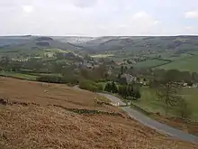
The modern village of Rosedale Abbey, built around the site of a former Cistercian Priory[1] is the main settlement in the valley. There is also a small hamlet at Thorgill.
Natural England maps
Maps for Rosedale showing Access, Designations and other criteria from Natural England:
Rosedale Head maps
Maps for Rosedale showing land above the Moorland Line:[lower-alpha 1][lower-alpha 2]
- MAGiC MaP : North York Moors – Rosedale Head.[3]
- MAGiC MaP : Rosedale Head – River Seven.[4]
- MAGiC MaP : River Seven – Reeking Gill – Seavey Hill.[5][lower-alpha 3]
- MAGiC MaP : Old Ralph cross – Young Ralph cross.[6][lower-alpha 4][lower-alpha 6]
Rosedale Abbey maps
- MAGiC MaP : Thorgill – Rosedale Abbey. [7] [8] [9]
- MAGiC MaP : Rosedale Abbey – Listed buildings. [12] [13]
- MAGiC MaP : Rosedale Abbey – PRIORY REMAINS. [14] [13] [lower-alpha 7] [lower-alpha 8]
Name
Name history
There was no mention of Rosedale in the Domesday Book of 1086 A.D. [lower-alpha 9]
However the name Rozebi [lower-alpha 12] [lower-alpha 14] is shown in the paragraph for Pickering. [lower-alpha 16]
Survey of English Place-Names : [22]
Name toponym
The toponym might be:
- Russi's valley [22]
- Valley beside high but relatively level moorland promontory [lower-alpha 17]
The name element dale is from Old Norse dalr or Middle English dale. [lower-alpha 18] [lower-alpha 19]
The name element rose is from Brittonic < rōs > and might be a reference to Blakey Ridge that defines the west side of the dale.
The name might have a Cornish influence since " Rose " place names are very common in Cornwall. [lower-alpha 20] The Cornish language was introduced into the area by the migration of tin miners from Cornwall. The majority of those came during the Cornish diaspora, [lower-alpha 21] [lower-alpha 22] however place name evidence suggests that Cornish miners might have arrived at an earlier date.[lower-alpha 23]
Examples of place names that might have a similar etymology:
- Raisdale, near Chop Gate in upper Bilsdale. [lower-alpha 25]
- Roseberry Topping, North Yorkshire.
- Roose, Cumbria.
- Melrose, Scottish Borders.
Rosedale Head
Heather moorland
Rosedale Head is at the top of the dale at the point where the River Seven rises from the ground.[4] The surrounding moorland is typical of the heather moorland of the North York Moors National Park.[26] In the 18th century the moorland belonged to the Helmsley Estate.[lower-alpha 26]
Rosedale Head separates Rosedale from its neighbouring dales to the north:
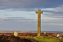
Old Ralph – Young Ralph
Old Ralph and Young Ralph are probably the best known of the many wayside crosses found in the North York Moors National Park. [lower-alpha 27]
The origin of the names Old Ralph and Young Ralph is not known, however the names might refer to members of the House of Neville:[lower-alpha 29]
| Name | Title | Life span | Notes |
|---|---|---|---|
| Ralph Neville | 1st Earl of Westmorland | c.1364 – 1425 | The title was created in 1397. |
| Ralph Neville | 2nd Earl of Westmorland | c.1406 – 1484 | |
| Ralph Neville[lower-alpha 30][lower-alpha 31] | 3rd Earl of Westmorland | c.1456 – 1499 | |
| Ralph Neville[lower-alpha 32][lower-alpha 33] | 4th Earl of Westmorland | c.1498 – 1549 | Rosedale priory closed in 1536.[lower-alpha 34] |
Old Ralph cross
Old Ralph cross is a monolithic wayside cross of hard gritstone that stands about 6 feet tall, possibly 11th century. The cross is a Grade II* listed building.[30] The cross is located on Ledging Hill the highest point on Blakey Ridge (OS ref: NZ 674 019).[6][lower-alpha 35]
Young Ralph cross
Young Ralph cross is a wayside cross of hard gritstone that stands about 10 feet tall, possibly 11th century. The cross is located on Ledging Hill (OS ref: NZ 677 021).[31] The distinctive profile of the cross is used as the emblem of the North York Moors National Park.
Examples of similar crosses across the North York Moors:
- Lilla Cross, Lilla's Howe, Fylingdales Moor.
- Mulgrave Castle – Mauley Cross erected by the Mauley family.
History

Mining
The extraction of ironstone probably began during the Roman period. [lower-alpha 36] [lower-alpha 37]
In the late 19th century the valley quickly became a major centre for iron-ore extraction. [lower-alpha 38] [lower-alpha 39] Mining took place from 1857[32] to 1928.[33] The ore was pre-processed by calcination, for which special kilns were built.[32]
The mines were served by the freight-only Rosedale Branch railway line that ran round the head of the valley, serving mine workings on either side, and across the moors to reach what is now the Esk Valley Line at Battersby Junction.[34][35] The railway line closed in 1929 after the last of the calcine dust extracted from the kiln waste had been sold.[33]
Rosedale Chimney Bank, one of the steepest roads in the United Kingdom,[36] provides a popular entrance point into the valley. A row of disused kilns and a former Royal Observer Corps Underground Monitoring Post[37] are both situated yards from its summit. In the adjacent Farndale Valley wild daffodils bloom around Easter time.[38]
Governance (19th century)
Historically the governance of Rosedale was split east–west by the River Seven.
In the 19th century Rosedale East Side was in the parish of Middleton and the wapentake of Pickering – Lythe ,[lower-alpha 40] while Rosedale West Side was in the parish of Lastingham and the wapentake of Ryedale. [lower-alpha 41]
| Name | Parish | Wapentake[lower-alpha 42] | Population[29] |
|---|---|---|---|
| Rosedale East Side | Middleton | Pickering – Lythe | 339 |
| Rosedale West Side | Lastingham | Ryedale | 179 |
Recent history
Few inhabitants of Rosedale work in farming. The majority of houses are bought as second homes and as such the permanent local population has been significantly reduced.
In mid-August Rosedale Show is held at Rosedale Abbey and attracts some 5,000 people from all parts of Britain. The show dates back to 1871 and is one of the oldest in North Yorkshire.[39][40]
The Frank Elgee memorial was erected in 1953 at Blakey Ridge on The North York Moors, overlooking Loose Howe at Rosedale Head.[41]
References
Notes
- MAGiC MaP: See Table of Contents:
- Designations > Moorland Line.[2]
- Designations > Scheduled Monument.
- Designations > Listed Building.
- See (Contents) > Rosedale Head.
- See River Seven > Name.
- Rosedale Head - Grade II* listed buildings:
- (West) – Old Ralph cross.
- (East) – Young Ralph cross.
- See Tumulus > United Kingdom.
- Rosedale Head - Scheduled Monuments:
- (North) – Western howes.[lower-alpha 5]
- (South) – Flat howe.
- PRIORY REMAINS (Historic England).[15]
. . .List Entry Summary:
- Heritage Category: Listed building
- Grade: II
- County: North Yorkshire
- District: Ryedale (District Authority)
- Parish: Rosedale East Side
- National Grid Reference: SE 72373 95927
- See Rosedale Abbey > Rosedale Priory.
- Parishes: Middleton ( William Page ).[18] . .No mention of ROSEDALE. . .is found in the Domesday Book. It must, however, have been in the king's hands together with Middleton [19] and Cropton, for these places afterwards formed part of the honour of Rosedale. The first lord of this fee was Turgis Brundos, lord of Liddell, who is styled Turgis de Rosedale in a charter of about 1125. He died before 1130–1 and was succeeded by William his son, founder of Rosedale Priory for nuns of the Cistercian order. . .[18]
- Note the different meanings:
- Chapter Seven THE SCANDINAVIAN ELEMENT (P H Reaney) [20] < -by > . . .The element '-by' is extremely common wherever the Scandinavian's settled in England, particularly in: . . .In England the usual meaning is " village "[20] [lower-alpha 10]
- The name element '-by' ( " village " ) suggests Old Norse influence. [lower-alpha 11]
- See Roose , Cumbria > . . .Roose was pronounced with a hard S, as in goose; now it is locally pronounced 'Rooze', due to the Cornish accent.
- Note the spelling with a 'Z', suggesting a Cornish or Brittonic influence. [lower-alpha 13]
- See Rosedale > History > Governance (19th century) > . . .Pickering – Lythe
- Historically Rosedale was in the parish of Middleton and the wapentake of Pickering – Lythe. [lower-alpha 15] The place name Rozebi is shown on line 10 of paragraph 4 on Page 3 Yorkshire in the Domesday Book. Middleton is shown on line 12 of the same paragraph.[21]
- Brittonic Language ( Alan James ) < rōs >.[23] .Proto-Semitic root *ra'š
- " headland, promontory "
- " something forth-standing "
- " something spread out "
- " something that can be proceeded across "
- " high but relatively level ground "
- " upland pasture, moorland "
- WiKtionary : Old Norse < dalr > " dale, valley ".
- WiKtionary : Middle English < dale > " dale, valley ".
- Chapter Five THE CELTIC ELEMENT (P H Reaney) Cornish < ros >.[24] .originally " projection, hill, hill spur ". . .later " hill covered with heath ". . .Among the numerous examples are:
- Roose, Rose, Rowse
- Rosecare
- Roskear, " hill-fort " < caer >
- Roseglos, " hill church " < eglos >
- Rosemullian
- Rosewarne, " hill with alder grove " < gwerne >
- Treskilling (Roskelin 1251), " holly hill " < celin >
- Tresmarrow (Rosmarc 1201), " horse hill " < margh >
- Penrose
- Trerose
- See Cornish diaspora > United Kingdom > . . .Ironstone mining in Cleveland. . .
- Note the Cornish place name Trennet ( " new home " ) at Raisdale near Chop Gate. See Rosedale > Name > Examples > Raisdale.
- See Ironstone mining in Cleveland and North Yorkshire > Early history > Killing Pits from Cornish kelin " holly ".
- Etymology for Trennet: See also:
- Note the Cornish name Trennet ( " new home " ) [lower-alpha 24]
- The Megalithic Portal Old Ralphs Cross - Ancient Cross . . . " On the north face at the centre of the cross piece are the initials CD with the date 1708. This stands for Charles Duncombe owner of what was in 1708 the 40,000 acre Helmsley Estate on which Old Ralph stood. . .[27]
- North York Moors National Park. . . " Young Ralph’s Cross, today the emblem of the National Park, can still be seen today located on the road between Castleton and The Lion Inn on Blakey Ridge. . .[28]
- ROSEDALE, EAST-SIDE (Thomas Langdale). . .The site was granted. . .to Ralph Nevile, Earl of Westmorland. . .About the time of the dissolution. . .[29]
- Rosedale priory closed in 1536, as a result of Henry VIII's dissolution of the monasteries. Following the closure the site was granted to Ralph Neville, 4th Earl of Westmorland.[lower-alpha 28]
- The 3rd Earl was the grandfather of the 4th Earl of Westmorland.
- "Old Ralph"...?
- The 4th Earl was the grandson of the 3rd Earl of Westmorland.
- "Young Ralph"...?
- Parishes: Middleton (William Page). . . " The nuns received confirmation of the lands of Rosedale by Robert de Stutevill. . .and continued in possession until the Dissolution, after which, in 1538, the reversion of the site of the priory, the manor and the advowson of Rosedale Church were granted to Ralph Earl of Westmorland. . . " [18]
- The Megalithic Portal Old Ralphs Cross - Ancient Cross. . . " It is located on Ledging Hill the highest point on Blakey Ridge. It originates from before 1200 and is probably 11th Century.. . .[27]
- See Ironstone mining in Cleveland and North Yorkshire > History > References > . . .Wilson, P R (2016)
- See also Mining in Roman Britain > Iron mining
- See Ironstone mining in Rosedale
- Parishes: Middleton ( William Page ).[18] . .there are ironstone mines on Rosedale Moor, a vein of great richness having been discovered some years ago, but being now nearly exhausted. Jet, alum shale, cement stones and excellent freestone are found in Rosedale, as well as coal, which, however, is no longer worked. . . .[18]
- ROSEDALE, EAST-SIDE ( Thomas Langdale ).[29] . .in the parish of Middleton , wapentake of Pickering-Lytbe - Pop. 339. . . .[29]
- ROSEDALE, WEST-SIDE ( Thomas Langdale ).[29] . .in the parish of Lastingham , wapentake of Rydale - Pop. 179 . . .[29]
- See List of wapentakes in Yorkshire
Citations
- "Rosedale History". Rosedale Abbey. Retrieved 3 January 2017.
-
- "Moorland Line Definition". Natural England, Magic in the Cloud. Retrieved 1 March 2023.
- "MAGiC MaP : North York Moors – Rosedale Head". Natural England, Magic in the Cloud.
- "MAGiC MaP : Rosedale Head – River Seven". Natural England, Magic in the Cloud.
- "MAGiC MaP : Reeking Gill – Seavey Hill". Natural England, Magic in the Cloud.
- "MAGiC MaP : Old Ralph cross – Young Ralph cross". Natural England, Magic in the Cloud.
- "MAGiC MaP : Thorgill". Natural England, Magic in the Cloud.
- Mapping criteria : See Table of Contents:
- Designations > Moorland Line
-
- "Moorland Line ( Definition )". Natural England, Magic in the Cloud. Retrieved 1 March 2023.
- "MAGiC MaP : Thorgill – Parish boundary". Natural England, Magic in the Cloud.
- Mapping criteria : See Table of Contents:
- Administrative Geographies > Parish boundary.
- Designations > Scheduled Monument.
- Designations > Listed Buildings.
- "MAGiC MaP : Rosedale Abbey – Listed buildings". Natural England, Magic in the Cloud.
- Mapping criteria : See Table of Contents:
- Designations > Listed Buildings.
- "MAGiC MaP : Rosedale Priory – Grid ref SE724959". Natural England, Magic in the Cloud.
-
- "PRIORY REMAINS". Historic England. Retrieved 1 March 2023.
- "MAGiC MaP : Ironstone mine – Rosedale East". Natural England, Magic in the Cloud.
- "MAGiC MaP : Ironstone mine – Rosedale West". Natural England, Magic in the Cloud.
- Page 1923, pp. 453–461.
-
- "MIDDLETON". Open Domesday. Retrieved 1 February 2023.
- Reaney 1969, p. 171-172.
-
- "PICKERING". Open Domesday. Retrieved 1 February 2023.
-
- "Survey of English Place-Names: Rosedale". University of Nottingham. Retrieved 1 February 2023.
- James 2019, p. 256.
- Reaney 1969, p. 95.
- Pawley White 1972, pp. 95–96.
-
- "All about heather". North York Moors National Park. Retrieved 3 August 2023.
-
- "Old Ralphs Cross - Ancient Cross in Yorkshire (North)". The Megalithic Portal. Retrieved 3 August 2023.
-
- "Land of myths & legends". North York Moors National Park. Retrieved 3 August 2023.
- Langdale 1822, p. 96.
- Historic England. "OLD RALPH CROSS (1179098)". National Heritage List for England. Retrieved 3 August 2023.
- Historic England. "YOUNG RALPH CROSS (1148563)". National Heritage List for England. Retrieved 3 August 2023.
- "Abandoned Communities. Rosedale. One". Retrieved 3 January 2017.
- "Abandoned Communities. Rosedale. Five". Retrieved 3 January 2017.
- Brown, Adrian (31 March 2008). "East Mines at Rosedale". BBC North Yorkshire. Retrieved 16 January 2014.
- "Rosedale Mines & Tramway Site records". Subterranea Britannica. Retrieved 16 January 2014.
- "Taking on the chimney climb". Darlington and Stockton Times. Retrieved 17 August 2020.
- "Rosedale ROC Post". Subterranea Britannica. Retrieved 17 August 2020.
- "Weekend Walk: Farndale Daffodils Walk". The Yorkshire Post. 16 April 2016. Retrieved 8 October 2018.
- "Our Rosedale Abbey". rosedalaeabbey.com. Retrieved 8 October 2018.
- Blackburne, Linda (15 August 2008). "Village searches its history for the 'women of steel'". The Yorkshire Post. Retrieved 8 October 2018.
- "Frank Elgee Memorial, Blakey Ridge". Hidden Teesside. Retrieved 13 April 2014.
Sources
- James, Alan G. (2019). The Brittonic Language in the Old North, A Guide to the Place-Name Evidence, Volume 2 (PDF). Scottish Place-Name Society. Retrieved 1 January 2023.
- Jennings, Bernard (1999). The Yorkshire Monasteries: Cloister, Land and People. Smith Settle. ISBN 9781858251059.
- Pawley White, Gunwyn (1972). A Handbook of Cornish Surnames. G. PAWLEY WHITE, Camborne.
- Reaney, P H (1969). The Origin of English Place Names. Routledge & Kegan Paul.
- Page, W. H., ed. (1923). 'Parishes: Middleton', A History of the County of York North Riding: Volume 2. Victoria County History. British History Online. pp. 453–461. Retrieved 1 February 2023.
- Langdale, Thomas (1822). A Topographical Dictionary of Yorkshire. LANGDALE.
External links
 Media related to Rosedale, North Yorkshire at Wikimedia Commons
- North York Moors, North York Moors National Park Authority
- The iron mining and railway community of Rosedale, Abandonedcommunities.co.uk (personal web site)
- A Walk in Beautiful Rosedale, Walkingenglishman.com