Ryōtsu, Niigata
Ryōtsu (両津市, Ryōtsu-shi) was a city located in Sado Island, Niigata Prefecture, Japan.
Ryōtsu
両津市 | |
|---|---|
Former municipality | |
 Ryotsu Port | |
.svg.png.webp) Flag .svg.png.webp) Seal | |
| Country | Japan |
| Region | Hokuriku |
| Prefecture | Niigata Prefecture |
| District | Sado District |
| Merged | March 1, 2004 (now part of Sado) |
| Area | |
| • Total | 233.37 km2 (90.10 sq mi) |
| Population (2003) | |
| • Total | 16,710 |
| Time zone | UTC+09:00 (JST) |
| Climate | Cfa |

10 subdivisions (former municipalities) in the Sado City. Ryotsu is located on the east of the island.
On March 1, 2004, Ryōtsu and the other 9 municipalities in the island were merged to create the city of Sado. Since then, Ryōtsu has been one of the 10 subdivisions of Sado City.
As of 2003, the city had an estimated population of 16,710 and a density of 71.60 persons per km2. The total area was 233.37 km2.
History
The city was founded on November 3, 1954.
On March 1, 2004, Ryōtsu, along with the rest of Sado Island (the towns of Aikawa, Kanai, Sawata, Hatano, Mano, Hamochi and Ogi, and the villages of Niibo and Akadomari (all from Sado District)), was merged to create the city of Sado.
Transportation
Bus
- Niigata Kotsu Sado
Highway
Sea
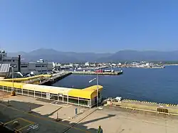
- Ryōtsu Port
- Sado Kisen Terminal
- Car ferry and Jetfoil services to/from Niigata Port
- Sado Kisen Terminal
Climate
| Climate data for Ryōtsu (1991−2020 normals, extremes 1978−present) | |||||||||||||
|---|---|---|---|---|---|---|---|---|---|---|---|---|---|
| Month | Jan | Feb | Mar | Apr | May | Jun | Jul | Aug | Sep | Oct | Nov | Dec | Year |
| Record high °C (°F) | 14.2 (57.6) |
19.9 (67.8) |
20.5 (68.9) |
26.9 (80.4) |
29.0 (84.2) |
30.7 (87.3) |
37.7 (99.9) |
38.8 (101.8) |
38.2 (100.8) |
29.5 (85.1) |
23.9 (75.0) |
19.0 (66.2) |
38.8 (101.8) |
| Average high °C (°F) | 5.8 (42.4) |
6.2 (43.2) |
9.5 (49.1) |
14.7 (58.5) |
19.7 (67.5) |
23.4 (74.1) |
27.4 (81.3) |
29.6 (85.3) |
26.2 (79.2) |
20.6 (69.1) |
14.6 (58.3) |
8.8 (47.8) |
17.2 (63.0) |
| Daily mean °C (°F) | 3.0 (37.4) |
3.1 (37.6) |
5.9 (42.6) |
10.8 (51.4) |
15.8 (60.4) |
20.0 (68.0) |
24.2 (75.6) |
26.1 (79.0) |
22.5 (72.5) |
16.8 (62.2) |
11.0 (51.8) |
5.7 (42.3) |
13.7 (56.7) |
| Average low °C (°F) | 0.2 (32.4) |
0.0 (32.0) |
2.2 (36.0) |
6.9 (44.4) |
12.2 (54.0) |
17.0 (62.6) |
21.5 (70.7) |
23.0 (73.4) |
19.2 (66.6) |
13.1 (55.6) |
7.3 (45.1) |
2.5 (36.5) |
10.4 (50.8) |
| Record low °C (°F) | −6.9 (19.6) |
−7.1 (19.2) |
−4.5 (23.9) |
−1.0 (30.2) |
3.6 (38.5) |
10.4 (50.7) |
13.8 (56.8) |
16.4 (61.5) |
10.8 (51.4) |
3.7 (38.7) |
−0.8 (30.6) |
−4.6 (23.7) |
−7.1 (19.2) |
| Average precipitation mm (inches) | 164.3 (6.47) |
118.7 (4.67) |
109.1 (4.30) |
104.6 (4.12) |
107.3 (4.22) |
138.9 (5.47) |
233.2 (9.18) |
142.7 (5.62) |
136.7 (5.38) |
139.2 (5.48) |
155.2 (6.11) |
210.0 (8.27) |
1,758.5 (69.23) |
| Average precipitation days (≥ 1.0 mm) | 23.0 | 18.1 | 15.7 | 11.7 | 9.7 | 9.3 | 11.4 | 9.1 | 11.4 | 12.9 | 16.9 | 22.7 | 171.9 |
| Mean monthly sunshine hours | 52.9 | 79.1 | 140.7 | 190.9 | 216.5 | 185.1 | 177.9 | 219.5 | 159.9 | 150.9 | 99.3 | 56.9 | 1,735.7 |
| Source: Japan Meteorological Agency[1][2] | |||||||||||||
See also
References
- 観測史上1~10位の値(年間を通じての値). JMA. Retrieved March 15, 2022.
- 気象庁 / 平年値(年・月ごとの値). JMA. Retrieved March 15, 2022.
External links
- Sado Tourism Association (in English)
- Sado Steam Ship (in English)
- Sado Geopark (in English)
Dissolved municipalities of | |||||||
|---|---|---|---|---|---|---|---|
| Niigata |
| ||||||
| Murakami |
| ||||||
| Tainai |
| ||||||
| Shibata |
| ||||||
| Agano |
| ||||||
| Gosen |
| ||||||
| Aga |
| ||||||
| Tsubame |
| ||||||
| Sanjō |
| ||||||
| Nagaoka |
| ||||||
| Kashiwazaki |
| ||||||
| Tōkamachi |
| ||||||
| Uonuma |
| ||||||
| Minamiuonuma |
| ||||||
| Jōetsu |
| ||||||
| Myōkō (Arai) |
| ||||||
| Itoigawa |
| ||||||
| Sado |
| ||||||
This article is issued from Wikipedia. The text is licensed under Creative Commons - Attribution - Sharealike. Additional terms may apply for the media files.