Saint-Cuthbert, Quebec
Saint-Cuthbert is a municipality in the Lanaudière region of Quebec, Canada, part of the D'Autray Regional County Municipality.
Saint-Cuthbert | |
|---|---|
 | |
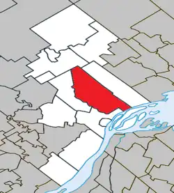 Location within D'Autray RCM | |
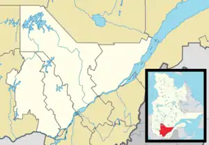 Saint-Cuthbert Location in central Quebec | |
| Coordinates: 46°09′N 73°14′W[1] | |
| Country | Canada |
| Province | Quebec |
| Region | Lanaudière |
| RCM | D'Autray |
| Settled | 1740 |
| Constituted | January 7, 1998 |
| Government | |
| • Mayor | Bruno Vadnais |
| • Federal riding | Berthier—Maskinongé |
| • Prov. riding | Berthier |
| Area | |
| • Total | 131.30 km2 (50.70 sq mi) |
| • Land | 132.46 km2 (51.14 sq mi) |
| There is an apparent contradiction between two authoritative sources | |
| Population (2011)[3] | |
| • Total | 1,839 |
| • Density | 13.9/km2 (36/sq mi) |
| • Pop 2006-2011 | |
| • Dwellings | 861 |
| Time zone | UTC−5 (EST) |
| • Summer (DST) | UTC−4 (EDT) |
| Postal code(s) | |
| Area code(s) | 450 and 579 |
| Highways | |
| Website | www |
Demographics
Population trend:[4]
- Population in 2011: 1839 (2006 to 2011 population change: -5.1%)
- Population in 2006: 1938
- Population in 2001: 1899
- Population in 1996: 1722 (or 1923 when adjusted for 2001 boundaries)
- Population in 1991: 1645
Private dwellings occupied by usual residents: 777 (total dwellings: 861)
Mother tongue:
- English as first language: 0.8%
- French as first language: 98.2%
- English and French as first language: 0%
- Other as first language: 1%
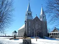
Church, St. Cuthbert, 2015
Education
Commission scolaire des Samares operates francophone public schools, including:
- École Sainte-Anne[5]
The Sir Wilfrid Laurier School Board operates anglophone public schools, including:
- Joliette Elementary School in Saint-Charles-Borromée[6]
- Joliette High School in Joliette[7]
See also
References
- "Reference number 341184 in Banque de noms de lieux du Québec". toponymie.gouv.qc.ca (in French). Commission de toponymie du Québec.
- "Geographic code 52062 in the official Répertoire des municipalités". www.mamh.gouv.qc.ca (in French). Ministère des Affaires municipales et de l'Habitation.
- Statistics Canada 2011 Census - Saint-Cuthbert census profile
- Statistics Canada: 1996, 2001, 2006, 2011 census
- "Sainte-Anne." Commission scolaire des Samares. Retrieved on September 23, 2017.
- "JOLIETTE ELEMENTARY ZONE." Sir Wilfrid Laurier School Board. Retrieved on September 17, 2017.
- "Joliette High School Zone Sec 1-5." Sir Wilfrid Laurier School Board. Retrieved on September 5, 2017.
External links
 Media related to Saint-Cuthbert, Quebec at Wikimedia Commons
- Saint-Cuthbert - MRC d'Autray
Adjacent Municipal Subdivisions | |
|---|---|
| Cities & Towns | |
|---|---|
| Municipalities | |
| Parishes | |
| |
This article is issued from Wikipedia. The text is licensed under Creative Commons - Attribution - Sharealike. Additional terms may apply for the media files.